Bryan Norcross: Atlantic alive with current, potential tropical systems while Idalia threatens Bermuda
A robust disturbance still over the African continent has a chance of developing around the middle of next week and will be in an environment conducive to development. On the current schedule, the system will move into the Atlantic tomorrow.

FOX Weather is your Hurricane HQ, streaming free 24/7.
(FOX Weather)
Updated at 9 a.m. ET on Friday, Sept. 1:
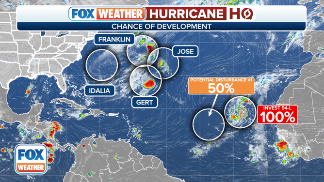
The tropical map is splattered with 6 weather systems that are, have been, or could develop into tropical storms or hurricanes. But one is of most interest. September is typically the busiest month in the tropics, and this year is living up to that reputation.
The area labeled Potential Tropical Disturbance #1 is where a robust disturbance still over the African continent has a chance of developing around the middle of next week. On the current schedule, the system will move into the Atlantic tomorrow. Computer forecast models show it fairly quickly developing into a tropical storm over the exceptionally warm Atlantic water and in conducive atmospheric conditions.
Areas to Watch in Atlantic on Sept. 1, 2023
(FOX Weather)
Long-range predictions show the disturbance tracking in the general direction of the Caribbean for several days but are not worth looking at until the system is over the ocean and develops a center of circulation. This system will likely have our attention through next week at least.
The National Hurricane Center is giving Disturbance #1 a medium chance of developing into a tropical depression or tropical storm over the next 7 days. If it does get named, it will be Tropical Storm Lee, assuming the system ahead of it becomes Katia soon.
Offshore of the U.S. East Coast, Idalia’s circulation merged with a cold front east of North Carolina, so it’s technically not a tropical system at the moment. Its official name is Post Tropical Cyclone Idalia.
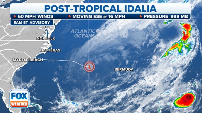
Here's the latest on Post-Tropical Cyclone Idalia.
(FOX Weather)
The front is a boundary between warm air to the south and cooler air to the north. Since the combo of Idalia and the front are over warm ocean water, eventually the air on the cool side of the front will heat up, so the front will fade away.
Over the next day or two, the system is expected to reconstitute itself into Tropical Storm Idalia. Over the weekend, the storm is forecast to be in the vicinity of Bermuda, though significant strengthening is not expected.
The long-range computer models are all over the place. The rule that forecasts for slow-moving systems without well-defined steering currents are prone to higher forecast errors applies in this case. The consensus of the computer forecasts is that Idalia will eventually get swept out to sea. A credible number turn it back toward New England or Atlantic Canada, however, bringing it uncomfortably close to the coast next week as a non-tropical storm. Stay informed in New England until its path is clear.
In the middle of the Atlantic, Hurricane Franklin, Tropical Storm Jose, and the nearby system, Tropical Depression Gert (a reconstituted version of the Gert from last week), are not a threat. They will die in the North Atlantic.
Closer to Africa, Invest 94L is on the cusp of turning into a tropical depression or Tropical Storm Katia. It will head north into the Atlantic and is not expected to be a threat once it is past the Cabo Verde Islands.
The peak of the season – the date when history has shown we are most likely to have a named storm active – is coming in 9 days. It’s time to stay aware and stay informed in the hurricane zone.