Back-to-back winter storms could bring snow, ice to Central US before moving east
Round two of snow and ice will move into the Central US later this week
Second winter storm this week will spread snow, ice across central and eastern US
A second winter storm this week will spread snow and ice across the West, Plains, Midwest and Northeast.
FOX Weather is closely watching the setup for the second powerful winter storm of the week that will likely bring snow and ice to the Central U.S. before it pushes into the Northeast later this week.
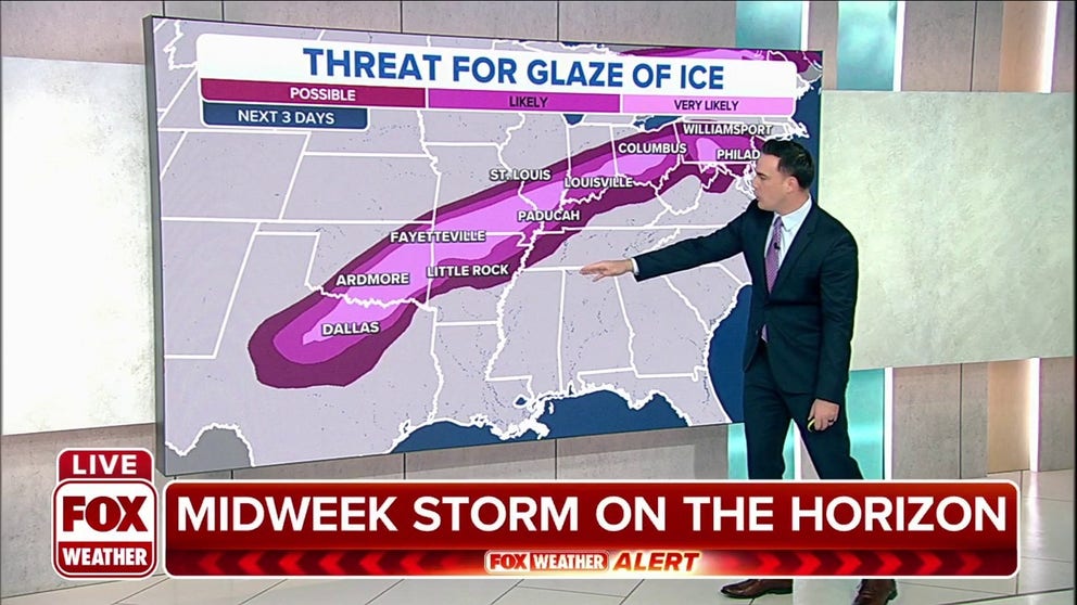
As if one winter storm wasn't enough, Winter Storm Warnings are currently issued for a stretch from central Montana, across the Dakotas, to central Minnesota and northern Wisconsin. Over a foot of snow is forecast in some parts of the Northern Plains through Tuesday.
![The jet stream will bring cold air and another winter storm to the northeast late this week.]() Image 1 of 3
Image 1 of 3The jet stream will bring cold air and another winter storm tnortheasttheast late this week. ( )
![]() Image 2 of 3
Image 2 of 3The jet stream will bring cold air and another winter storm tnortheasttheast late this week. ( )
![The jet stream will bring cold air and another winter storm to the northeast late this week.]() Image 3 of 3
Image 3 of 3The jet stream will bring cold air and another winter storm tnortheasttheast late this week. ( )


On Wednesday, the jet stream will dip into the Southern Plains, dropping temperatures before it slides to the east, bringing fresh, cold arctic air. In the Southeast, warm and humid air from the Gulf Stream will smack into the cold air bringing rain to the South and even parts of the mid-Atlantic by midweek.
WINTER STORM TO BLANKET THE N. PLAINS AND MIDWEST IN SNOW
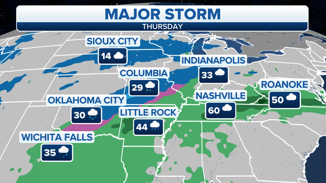
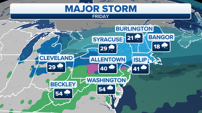
As the system moves over the U.S., heavy snow and ice will be a concern in the Central Plains on Wednesday before the wintry precipitation moves into the Ohio Valley by Thursday and then arrives in the mid-Atlantic and Northeast on Friday.
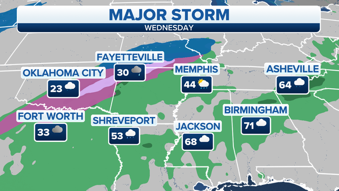
Cooler weather and rain will return to the South by mid-week.
(FOX Weather)
FOX Weather is watching the chance for snow and ice in major cities including Pittsburgh, Philadelphia, New York and Boston.
On Thursday, Ohio and Pennsylvania could see ice that may make traveling conditions hazardous.
After the threat of severe weather, including the potential for tornadoes, early in the week, the second weather system will bring more rain to parts of the Tennessee Valley which may receive another round of intense rain, resulting in flash flooding and prolonged river flooding on Thursday.
Cooler weather and rain will return to the South by mid-week as potential snow moved across the Central U.S.
(FOX Weather)
By Friday, the winter storm will move over the northeast, potentially bringing snow and ice to Massachusetts, Vermont and New York.
A second winter storm will move from Central U.S. intnortheasttheast by late week.
(FOX Weather)
FOX Weather will continue to update its forecasts as models continue to align.