Atmospheric river soaks Pacific Northwest again this weekend with heavy rain, mountain snow
Heavy rain returned to the region this weekend, adding more water to swollen rivers that have mostly returned to their banks after reaching moderate to even record flood levels last week but are still running high.
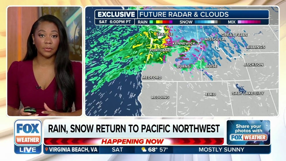
Rain, snow return to Pacific Northwest on Saturday
River levels are dropping in the Pacific Northwest, but there's more rain and snow rolling in Saturday. The next surge of Pacific moisture is streaming into the area now, and the region will be particularly sensitive to any additional rain after receiving significant rain earlier this week.
SEATTLE – An atmospheric river is dumping another round of heavy rain and mountain snow across the Pacific Northwest, which is still dealing with swollen rivers and saturated grounds from a deadly rainstorm last week.
WHAT IS A 'PINEAPPLE EXPRESS'?
The storm began drenching the region Saturday morning. It promised a solid 24-30 hours of steady rain that would continue into Sunday afternoon, adding more water to rivers that just returned to their banks after reaching moderate to even record flood levels last Tuesday and Wednesday and are still running high.
![Atmospheric River Conditions In Pacific Northwest Brings Heavy Rains And Flooding To Region]() Image 1 of 14
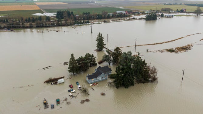
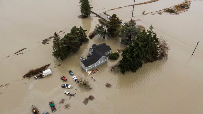
Image 1 of 14STANWOOD, WASHINGTON - DECEMBER 6: In an aerial view, floodwaters surround a home on December 6, 2023 in Stanwood, Washington. Atmospheric river conditions in the region brought heavy rains and flooding. (Photo by David Ryder/Getty Images) ( )
![Atmospheric River Conditions In Pacific Northwest Brings Heavy Rains And Flooding To Region]() Image 2 of 14
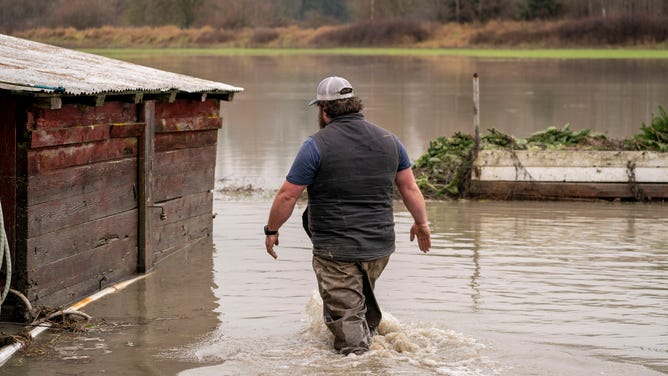
Image 2 of 14SILVANA, WASHINGTON - DECEMBER 6: Hunter Backlund wades through floodwaters at his family's property on December 6, 2023 near Silvana, Washington. Atmospheric river conditions in the region brought heavy rains and flooding. (Photo by David Ryder/Getty Images) ( )
![Flooding impacts the state of Washington.]() Image 3 of 14
Image 3 of 14Flooding impacts the state of Washington. ( Snohomish County DEM)
![Atmospheric River Conditions In Pacific Northwest Brings Heavy Rains And Flooding To Region]() Image 4 of 14
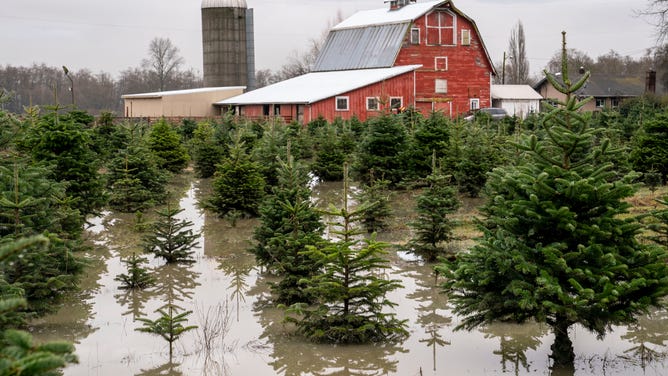
Image 4 of 14SILVANA, WASHINGTON - DECEMBER 6: Floodwaters enter a Christmas tree farm on December 6, 2023 near Silvana, Washington. Atmospheric river conditions in the region brought heavy rains and flooding. (Photo by David Ryder/Getty Images) ( )
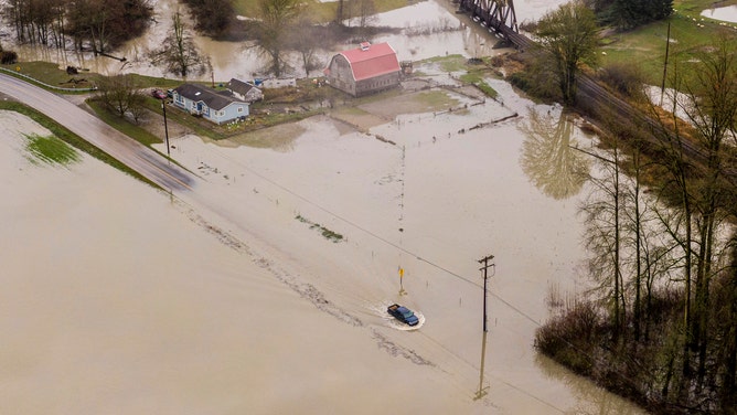
![Atmospheric River Conditions In Pacific Northwest Brings Heavy Rains And Flooding To Region]() Image 5 of 14
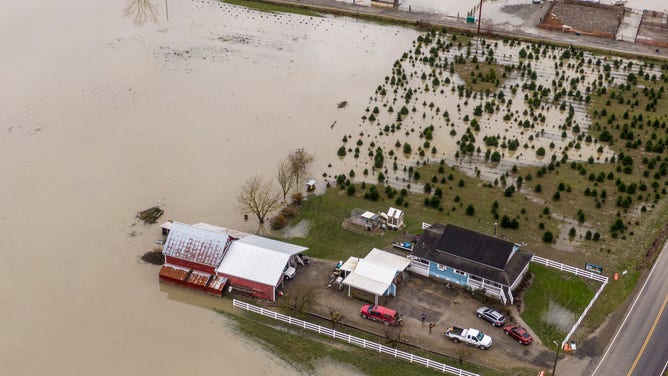
Image 5 of 14SILVANA, WASHINGTON - DECEMBER 6: In an aerial view, floodwaters surround a barn on December 6, 2023 near Silvana, Washington. Atmospheric river conditions in the region brought heavy rains and flooding. (Photo by David Ryder/Getty Images) ( )
![Atmospheric River Conditions In Pacific Northwest Brings Heavy Rains And Flooding To Region]() Image 6 of 14
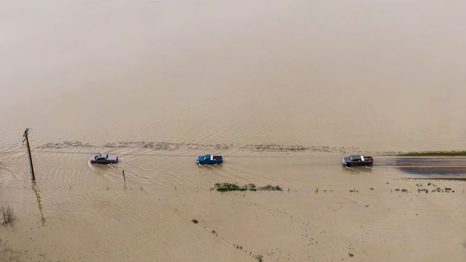
Image 6 of 14SILVANA, WASHINGTON - DECEMBER 6: In an aerial view, trucks drive through floodwaters on December 6, 2023 near Silvana, Washington. Atmospheric river conditions in the region brought heavy rains and flooding. (Photo by David Ryder/Getty Images) ( )
![]() Image 7 of 14
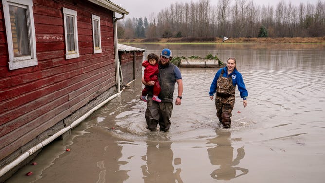
Image 7 of 14SILVANA, WASHINGTON - DECEMBER 6: Hunter Backlund carries his niece, Rebecca Backlund, while walking through floodwaters with his sister, Rachel Backlund at his Christmas tree farm on December 6, 2023 near Silvana, Washington. Atmospheric river conditions in the region brought heavy rains and flooding. (Photo by David Ryder/Getty Images) ( )
![Atmospheric River Conditions In Pacific Northwest Brings Heavy Rains And Flooding To Region]() Image 8 of 14
Image 8 of 14SILVANA, WASHINGTON - DECEMBER 6: In an aerial view, a truck drives through floodwaters on December 6, 2023 near Silvana, Washington. Atmospheric river conditions in the region brought heavy rains and flooding. (Photo by David Ryder/Getty Images) ( )
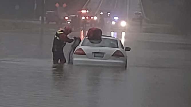
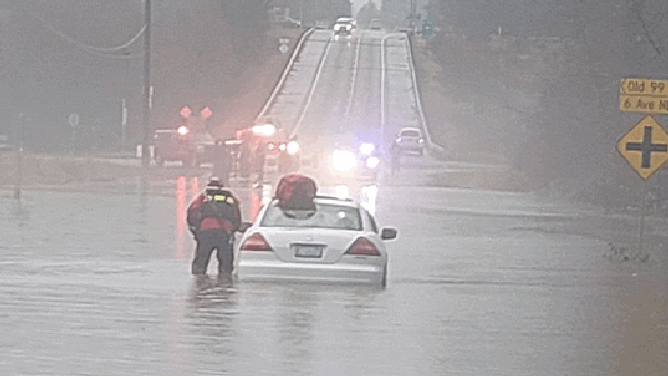
![Washington flooding]() Image 9 of 14
Image 9 of 14Flooding leads to water rescue in Snohomish County, Washington. (Snohomish County Sheriff's Office)
![Flooding in Silvana, Washington, on Tuesday, Dec. 5, 2023.]() Image 10 of 14
Image 10 of 14Flooding in Silvana, Washington, on Tuesday, Dec. 5, 2023. (Willow and Jim's Country Cafe/Facebook)
![Images showing dramatic flooding in Washington on Dec. 5, 2023.]() Image 11 of 14
Image 11 of 14Images showing dramatic flooding in Washington on Dec. 5, 2023. ( )
![Flooding in Silvana, Washington, on Tuesday, Dec. 5, 2023.]() Image 12 of 14
Image 12 of 14Flooding in Silvana, Washington, on Tuesday, Dec. 5, 2023. (Willow and Jim's Country Cafe/Facebook)
![Flooding in Silvana, Washington, on Tuesday, Dec. 5, 2023.]() Image 13 of 14
Image 13 of 14Flooding in Silvana, Washington, on Tuesday, Dec. 5, 2023. (Willow and Jim's Country Cafe/Facebook)
![Atmospheric River Conditions In Pacific Northwest Brings Heavy Rains And Flooding To Region]() Image 14 of 14
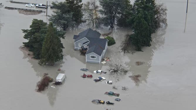
Image 14 of 14STANWOOD, WASHINGTON - DECEMBER 6: In an aerial view, floodwaters surround a home on December 6, 2023 in Stanwood, Washington. Atmospheric river conditions in the region brought heavy rains and flooding. (David Ryder)


As much as 5 inches of additional rain could fall
This weekend's atmospheric river differs in three ways from its predecessor last week: It’s a bit weaker, it’s moving faster, and it isn’t anywhere near as warm as the record-breaking temperatures that brought snow levels as high as 10,000 feet last week. Those changes will keep snow levels lower, meaning less water will immediately reach the rivers.

(FOX Weather)
On the other hand, the return of impactful snow and then freezing rain to the mountains and their passes will present travel challenges to those heading into the passes until snow levels rise once again above pass levels on Sunday. And rainfall amounts will still be impressive.
By Monday, about another 1-2 inches of rain is likely along the coastal regions and mountains.

(FOX Weather)
"This is a lot of heavy rain kind of moving in and butting up against the Coastal Range and Olympic Mountains … so that’s going to add to the flood factor there," FOX Weather Meteorologist Britta Merwin said.
Wind gusts are likely to reach 45 mph along the coast and in far northwestern Washington, adding a sideways angle to the pelting rain. Wind Advisories are in effect through Sunday morning.
The rain is coming on top of what has already been a month's worth of rain in the Northwest.

(FOX Weather)
So far, it appears any new flooding impacts will be minor but still bear watching. Flood Watches are in effect for the northwestern Oregon and Washington's Skokomish River. The National Weather Service warns some rivers in the central Washington Cascades may return to flood stage if the rain persists.

(FOX Weather)
Travel impacts will also return to the mountains, with winter weather alerts in effect for the eastern Washington Cascades.
Snow changed over to freezing rain in the mountain passes by Sunday morning, with snow also pushing into Wyoming, Montana and Idaho.
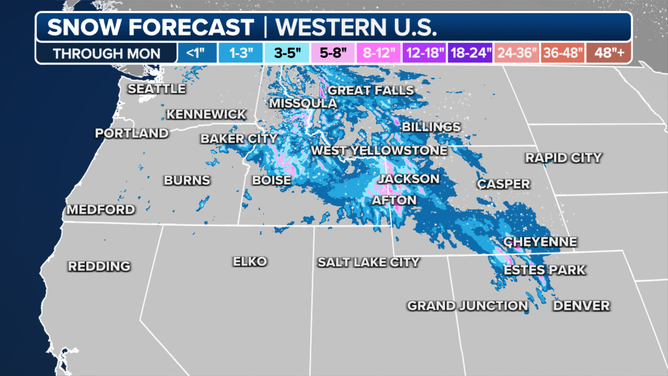
Snow forecast through Monday.
(FOX Weather)
Snow will spread east into parts of the inland Northwest and far northern Rockies, with moderate snow accumulations of 2-4 inches likely around Spokane, Washington, and northern Idaho through Sunday.
The long-range forecast shows a break in the weather early this week as a brief ridge of high pressure allows the region to wring out.