3 tropical disturbances roam the Atlantic in unusually active end to June
Once these current systems are off the board, we’ll have a pause in the Atlantic tropics
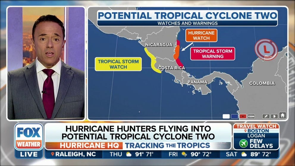
Potential Tropical Cyclone Two could strenghten into Tropical Storm Bonnie this afternoon
The system is expected to approach hurricane strength (75+ mph winds) over the southwestern Caribbean, and slam into Central America on Friday.
Tropical Disturbance No. 1, which the National Hurricane Center is officially designating Potential Tropical Cyclone Two, will move away from South America and into the southwestern Caribbean on Thursday. Finally, it will find atmospheric conditions that should support the system organizing into Tropical Storm Bonnie.
The system’s rapid forward speed and track near land have kept it from organizing so far, but those negative factors should end on Thursday.
HURRICANE WATCH ISSUED AS SYSTEM THAT COULD BECOME BONNIE EYES CENTRAL AMERICA
Assuming the system organizes and strengthens as forecast, a strong Tropical Storm Bonnie will make landfall on Friday in extreme southern Nicaragua or northern Costa Rica. It could reach hurricane strength before coming ashore. The system should have enough organization to survive the trip across that narrow part of Central America so that when it emerges into the Eastern Pacific Ocean on Saturday, its circulation will be intact.

(FOX Weather)
If this happens, the storm will continue to be called Bonnie. In the years before 2000, systems that crossed Central America got a new name from the Eastern Pacific list of storm names. Before Bonnie, assuming it happens, only Otto in 2016 made the crossing, survived, and kept its Atlantic name in the Eastern Pacific.
HOW TO WATCH FOX WEATHER ON TV
Gulf disturbance
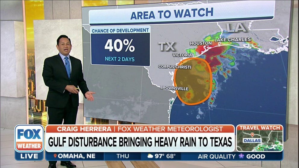
Tropical disturbance to bring several inches of rain to Texas and Louisiana
Over the next few days, the upper Texas coast and southwestern Louisiana could see several inches of rain from the slow-moving tropical disturbance.
Disturbance No. 2, just offshore of South Texas in the Gulf of Mexico, is accompanied by very heavy tropical thunderstorms. There is some chance that the thunderstorms might sufficiently wrap around the center of rotation on Thursday that the NHC will designate the system a tropical depression. But the name is irrelevant to the effects.

(FOX Weather)
Tropical downpours will move over the Texas coast, including the Houston metro area, from Thursday night into Friday. A few to several inches of rain is forecast, which would often be a problem. Coastal Texas has been in a drought condition, however, so the ground can take more water than usual. Still, localized flash flooding is possible in areas that receive 2 to 3 inches of rain in an hour, which is possible in these strong thunderstorm cells.
TRACKING THE TROPICS: WHAT INVEST 95L IN THE GULF MEANS FOR TEXAS
Third disturbance
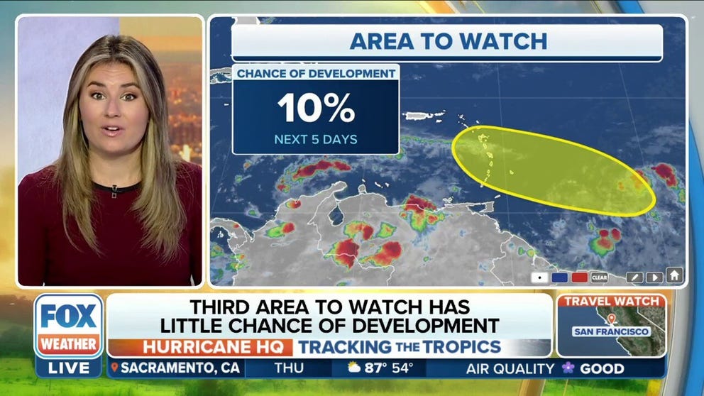
Third area to watch in Atlantic has little chance of development
This disturbance has a low chance (10%) of development over the next 5 days.
Tropical Disturbance No. 3 will approach the eastern Caribbean islands on Friday, reaching Puerto Rico and the Virgin Islands from Saturday into Sunday. This is a robust system carrying a lot of tropical moisture and gusty winds, but the atmospheric conditions do not appear conducive for it to organize into a tropical depression or tropical storm.
CLICK HERE TO GET THE FOX WEATHER UPDATE PODCAST

(FOX Weather)
The consensus of the computer forecast models is that the disturbance will remain just a moisture surge as it sweeps through the Caribbean islands over the next few days. On this schedule, it would bring a better chance of rain to South Florida early next week.
Long-range computer model forecasts show hostile atmospheric conditions across most of the Atlantic tropics. If they’re right, once these current systems are off the board, we’ll have a pause.