South Florida braces for potentially life-threatening flash flooding as storm nears
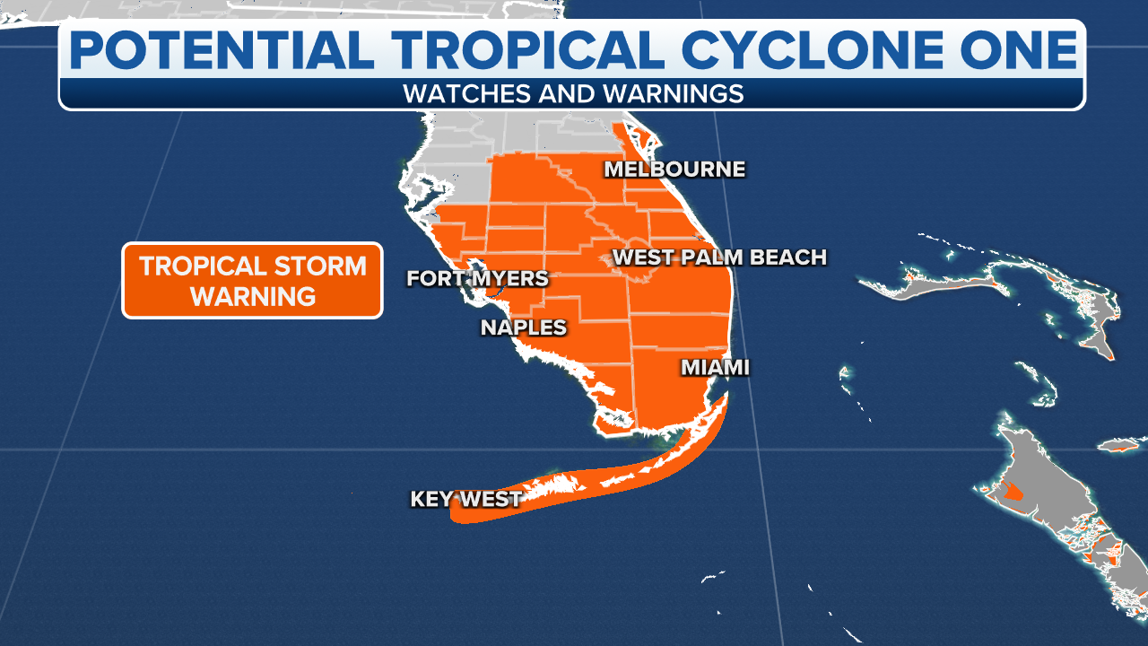
Tropical Storm Warnings are in effect for the entire southern half of the Florida Peninsula and the Keys, but the highest threat of strong winds will be in areas exposed to onshore winds along the coast and in high-rise buildings.
Coverage for this event has ended.
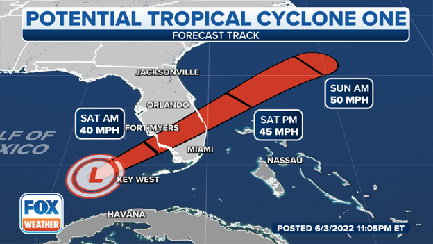
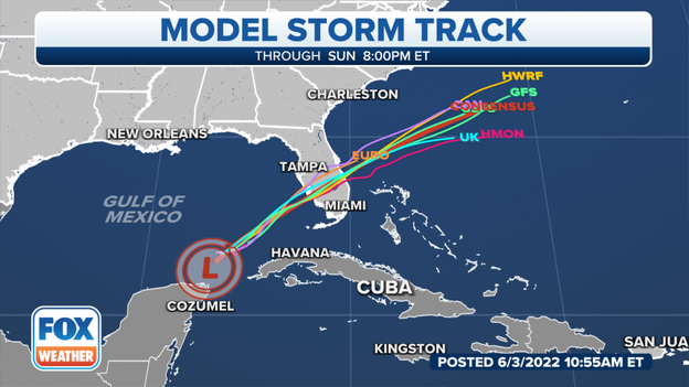
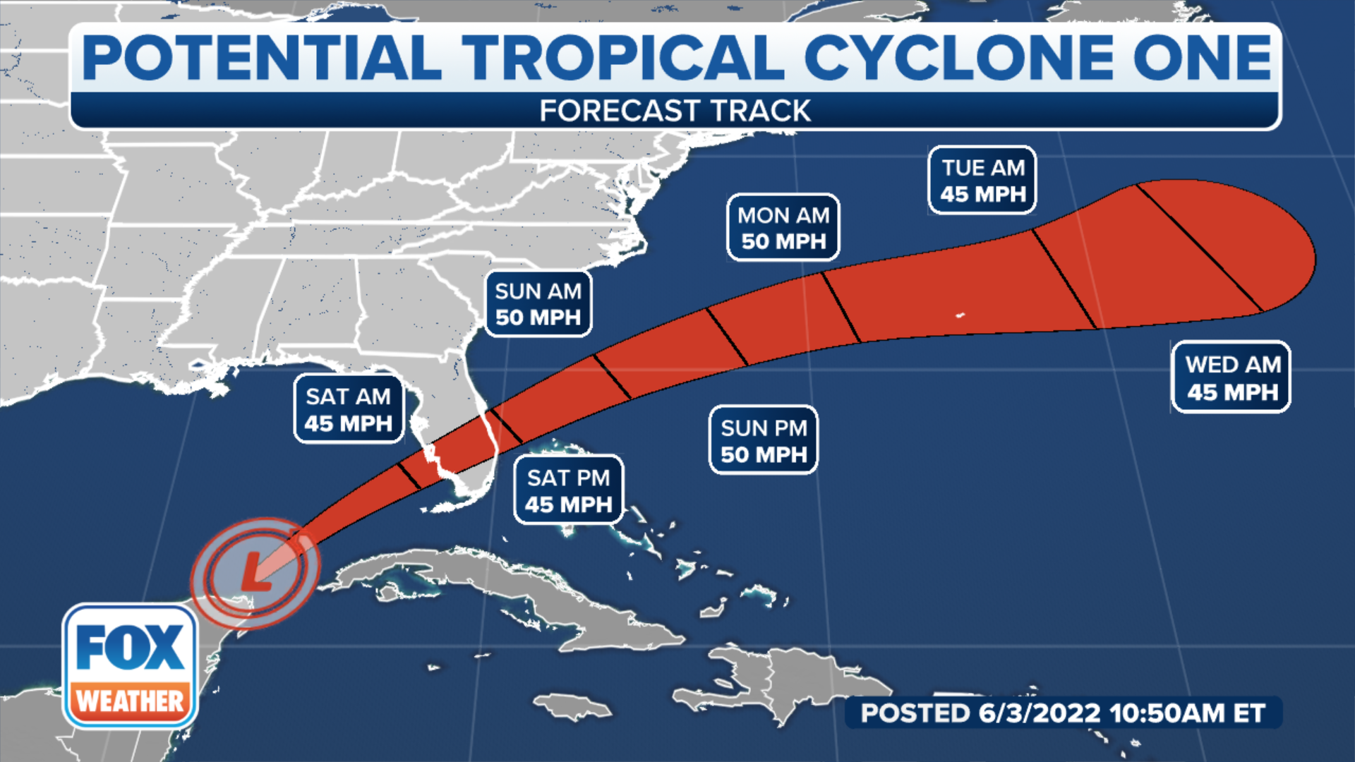
Updated forecast cone for Potential Tropical Cyclone One
The tropical disturbance is expected to cross the Florida Peninsula on Saturday.
Latest forecast: Click Here
A threat of tornadoes and isolated flooding will continue overnight.
Off and on rain is expected to continue through the evening in South Florida as the rain shield associated with Potential Tropical Cyclone One moves through.
Latest forecast: Click Here
Saturday Forecast
The heaviest rain associated with the tropical disturbance will be off the Florida East Coast by Saturday evening. Scattered storms will be possible into the workweek, but they won't produce the flooding downpours that the area saw from the tropical system.
Officials in Brevard County are closely watching the radar for heavy rain.
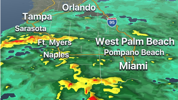
FOX Weather 3D Radar
The FOX Weather 3D Radar is picking up tropical downpours throughout the Keys and South Florida. Meteorologists expect the wet weather to continue through the night.
Track the tropical system on the FOX Weather app.
Google Play: Free Download
App Store: Free Download
Satellite image
According to the office of the Cuban President, at least two people have died as a result of the tropical weather and a third is missing. Heavy rainfall across the island has increased the landslide threat.
Coastal areas of South Florida could see a storm surge of up to 3 feet.
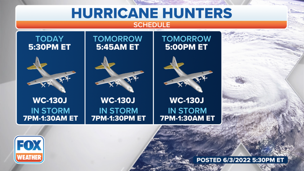
Hurricane Hunter aircraft
Hurricane Hunters are en route to the system that is about 300 miles off the coast of Southwest Florida. Throughout the day, the disturbance has not gotten better organized. Data from the plane will help the National Hurricane Center determine if the disturbance is getting better organized.
See inside a Hurricane Hunter plane: Click Here
Latest forecast cone from the National Hurricane Center: Click Here
The U.S. Coast Guard has elevated to port condition Whiskey, meaning sustained winds between 39-73 mph are possible within the next 72 hours.
"We encourage boaters to monitor the radio for safety broadcast information, secure all loose gear, and find the best course back to shelter if out in the water," the USGC Southeast tweeted.
Read the latest forecast from the FOX Weather team: Click Here
The biggest impacts will be widespread heavy rain and wind. Already water-logged South Florida doesn't need any more rain but in parts of Central and North Florida it could be a welcome sight.
Off and on flooding has been reported in South Florida as bands of and on continue. Parts of Miami Dade County could see upwards of around half a foot of rain before the tropical system moves out of the Atlantic.
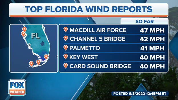
Highest wind gusts
The highest wind gust so far from the tropical disturbance was measured at 47 mph in the Tampa Bay region. Winds have also gusted to 40 mph in the Keys. Wind gusts in the 40s can knock small branches and lead to minor power outages.
Winds are expected to remain elevated thru at least Saturday: Latest Forecast
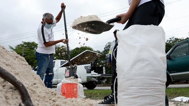
People fill sandbags in Pembroke Springs, Fla., as they prepare their homes for the expected arrival of a Tropical Storm. (Photo: Joe Raedle/Getty Images)
People fill sandbags as they prepare their homes for the expected arrival of a Tropical Storm on June 03, 2022 in Pembroke Pines, Florida.
(FOX Weather)
Numerous instances of flooding are expected late Friday into Saturday as a tropical disturbance brings widespread heavy rain to South Florida.
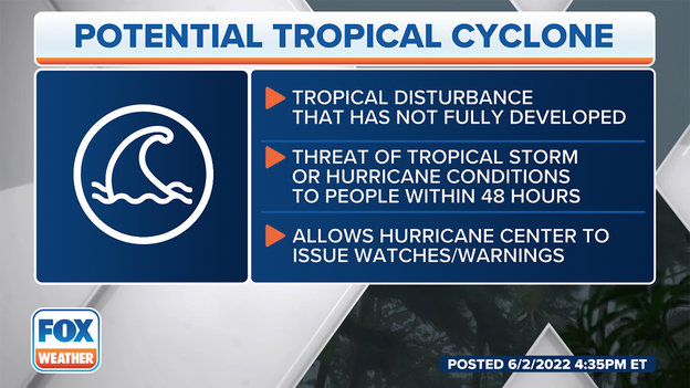
The National Hurricane Center has designated it a Potential Tropical Cyclone which allows them to issue their full suite of products like watches, warnings and forecast cone, before a storm has fully become a tropical depression or storm.
The storm is expected to become a tropical depression or storm later today or tonight.
Regardless of strength, heavy rain and life-threatening flooding are all but certain in South Florida and will be the main threat with this system.
A widespread 5-10 inches of rain is expected, and some areas could get up to one foot of rain.
Dangerous heavy rain will begin this evening and last into the overnight hours; rain rates could exceed 3 inches per hour.
A few tornadoes could quickly spin up, especially in the Florida Keys. This will be most likely Friday afternoon into Saturday morning.
Overall, it may well be dangerous to be on the roads in the southern part of Florida Friday into the daytime on Saturday. Residents should consider changing their plans so they are home during the gustiest and rainiest part of the storm.
It is likely that 1-3 feet of storm surge is expected in South Florida. This may result in minor flooding right along the coast but significant impacts are not expected.
(FOX Weather)
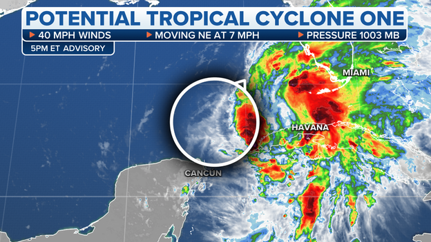
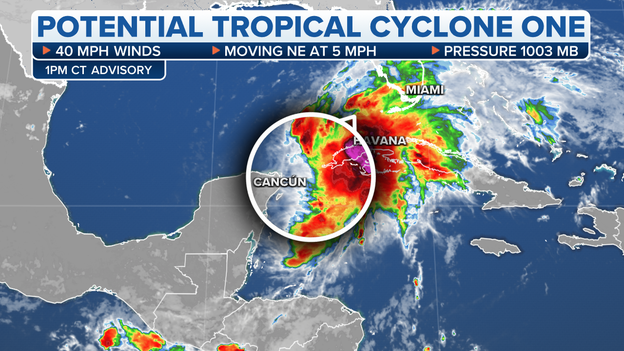
2 p.m. EDT UPDATE: Aircraft data from the National Hurricane Center indicates disturbance from Potential Tropical Cyclone One has changed little in organization during the past several hours.
Heavy rains are now spreading across western Cuba and southern Florida.
Wind speeds are currently 40 mph and moving northeast at 5 mph.
The storm is located 395 miles southwest of Ft. Myers, Florida and 150 miles north-northeast of Cozumel, Mexico.
The FOX Weather Beast is in South Florida to track Potential Tropical Cyclone One as it approaches landfall. Watch and follow along on the Facebook Live below.
From sandbags, flushing without power and evacuations, here's everything you need to know during your first hurricane season.

(FOX Weather)
Tropical depression, tropical storm and hurricane are terms you hear every hurricane season, but "potential tropical cyclone" is a relatively new phrase with which you might not be very familiar.
Introduced by the National Hurricane Center in 2017, a potential tropical cyclone permits the NHC to issue routine advisories on a system that has not yet developed into a tropical depression or tropical storm but brings a threat of 39-plus-mph winds to land within 48 hours.
Click the story below to read more.
As of midday Friday, this developing system located more than 400 miles southwest of Fort Myers, Florida, was producing clusters of showers and thunderstorms.
Bands of rain and gusty winds had already arrived in parts of South Florida and the Florida Keys as tropical moisture streams well to the northeast of the system's center.

(FOX Weather)
Tropical Storm Warnings have been issued across Central and South Florida as Potential Tropical Cyclone One begins to spread heavy rain and gusty winds onshore in the Sunshine State.
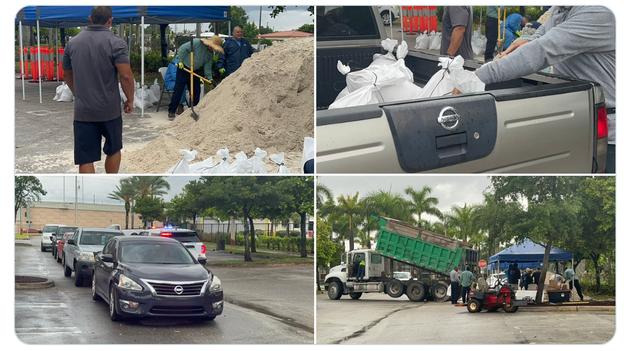
(City of Miami)
In preparation for the potential of major flooding, Miami city officials are distributing sandbags to help homeowners.
Sandbags are available at these locations while supplies last until 7:30 p.m. EDT Friday:
Grapeland Park - 1550 NW 37th Ave, Miami FL 33125
Little Haiti Soccer Park - 315 NE 62 Street, Miami, FL 33138
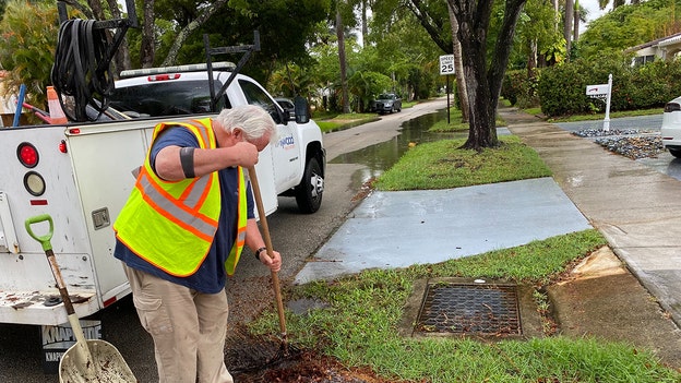
(City of Hollywood, Florida)
Public utility crews in Hollywood, Florida, are out working to clear storm drains, checking the stationary pumping stations and deploying auxiliary pumps in low-lying areas prone to flooding.
Live Coverage begins here