Significant flash flooding, severe weather in Southeast
Nearly 15 million people are under the risk for severe weather. Hail, damaging winds and tornadoes are possible from Texas into the Mid-Atlantic.
Coverage for this event has ended.
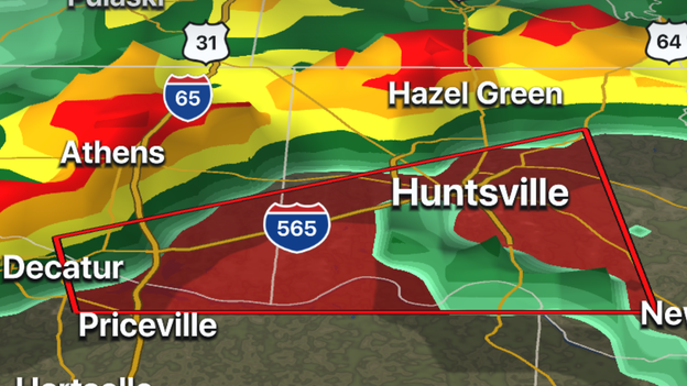
Madison County (Alabama) Sheriff reports damage in Charity Lane area of Hazel Green: Roof damage to homes; structural damage to Walmart, Hibbett's Sports Goods and Verizon store. Power lines and power poles down in area.
FOX Weather 3D Radar
Tornado sirens are going off in Huntsville, AL ahead of a storm with a potential of producing a tornado, along Interstate 565.
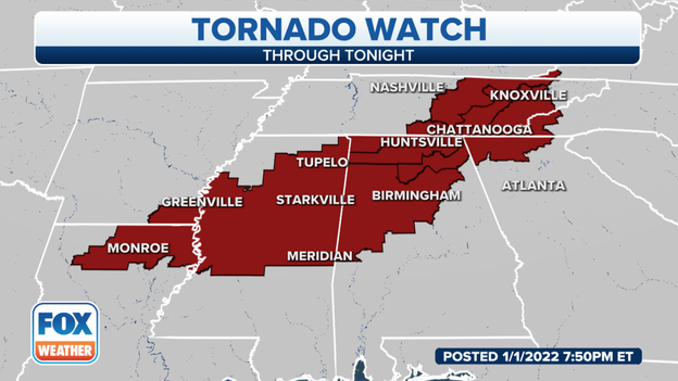
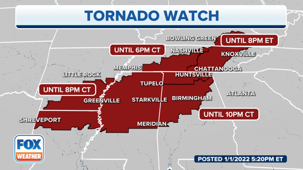
A new tornado watch box has been issued for parts of AL, TN and GA
Tornado Watches are now in effect for nearly 6 million people across the Southeast. The Storm Prediction Center issued the 7th watch of 2022 after 7:30 p.m. for counties in Georgia, Tennessee, Alabama and North Carolina.
The newest watch box is in effect until 3 a.m. EST.
FOX Weather 3D Radar
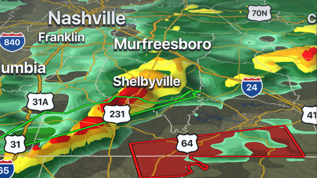
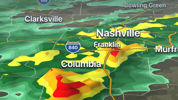
Radar is tracking a storm with rotation that is near Huntland, Tennessee. The storm is moving east at 45 mph. Other locations impacted by this storm include Elora, Maxwell, Beans Creek, Plevna and Flintville.

Heavy rainfall over Columbus, MS
The Tornado Warning that was issued for areas around Columbus, MS has been allowed to expire. Traffic cameras show heavy rains are now falling over the region.
Forecast models show off and on rain will continue overnight before a cold front helps to clear out parts of the Southeast.
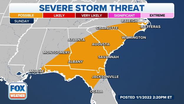
Sunday's severe weather threat zone
The threat of strong to severe thunderstorms will shift eastward on Sunday and include areas from the Gulf Coast into the Carolinas.
Sunday forecast: CLICK HERE
Tornado watch boxes stretch from Louisiana to Kentucky
Nearly 8 million Americans are under a Tornado Watch. A watch means conditions are favorable for storms to have rotation and produce a tornado.
What you should do to prepare for tornadoes: CLICK HERE
FOX Weather 3D Radar is tracking a severe thunderstorm in southern Tennessee.
Meteorologists are watching a storm near I-65 for the potential of producing a tornado near the Alabama-Tennessee border. The storm is moving northeast at 50 mph.
Track the storm on FOX Weather 3D Radar: CLICK HERE
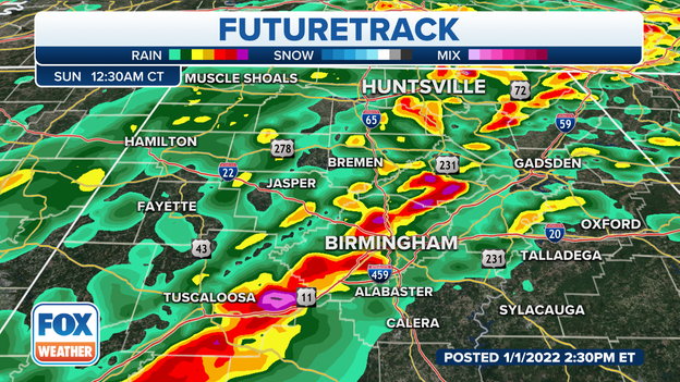
FOX Weather futurecast for after midnight.
Even though Birmingham, Alabama will see rain before midnight, a significant line of storms likely won't impact the area until late Saturday and during the overnight hours. FOX Weather's futurecast shows what could be strong to severe storms moving eastward through central parts of the state around 12:30 a.m. CDT.
FOX Weather's Steve Bender explains what to do if a tornado is threatening your neighborhood.
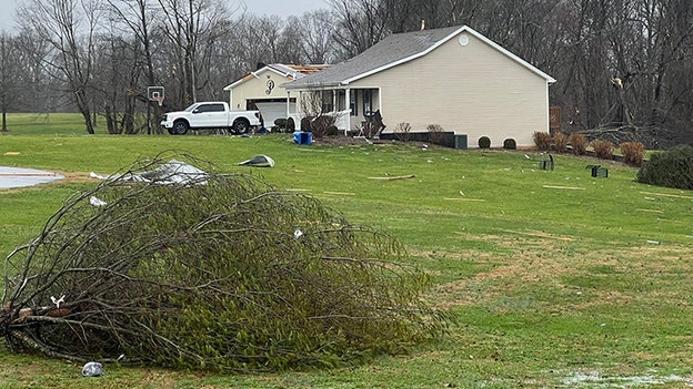
Taylor County, Kentucky, Emergency Management Director Ronnie Dooley tells FOX Weather that there's significant damage in Taylor County.
About 10 homes are damaged, power lines and trees down, and reports of minor injuries.
(@ChadMardis /Twitter)
@ChadMardis on Twitter shared this photo on Twitter of storm damage in the Woodhill subdivision in Taylor County, Kentucky.

(Floyd County Sheriff's Department)
The Floyd County Sheriff's Department, in Prestonsburg, Kentucky, posted this photo to Facebook on Jan. 1, 2022, showing flooded roads on Route 1426 at Harold near Tan Yard Hollow.

@BGTonite / Twitter
Storm damage has been reported at Thornton Furniture in Bowling Green, Kentucky.

(Courtesy: 98.7 WHOP FM)
98.7 WHOP FM in Hopkinsville, Kentucky, reports significant damage from a possible tornado on the east side of the town near East Ninth and Campbell streets. No immediate reports of significant injuries.
Just over 3.2 million people are currently under a Tornado Watch as the severe weather picks up in the Tennessee and Ohio valleys.
If you are in any of the areas at risk for severe storms this weekend, make sure you have severe weather alerts turned on in your FOX Weather app so you can receive potentially life-saving warnings issued by the National Weather Service.
As of 1:30 p.m. Eastern, here are the latest power outages.
Kentucky Outages: 11,822
Tennessee Outages: 20,975
(FOX Weather)
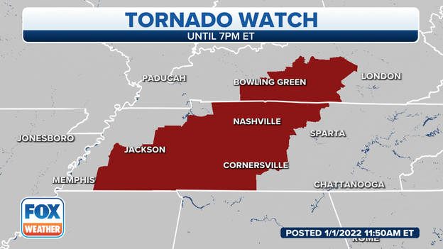
A Tornado Watch has been issued for parts of Kentucky and Tennessee until 7 p.m. Eastern.
Footage by Johnnie Nicholson shows a stormy sky in the early hours of Saturday.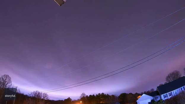
Timelapse footage captured on New Year’s Day shows stormy weather rolling over London, Kentucky, as the National Weather Service warned of severe thunderstorms in the area with winds of up to 70 mph, large hail, and possible tornadoes.
Footage by Johnnie Nicholson shows a stormy sky in the early hours of Saturday.
Storms may produce strong tornadoes, destructive winds, and damaging hail.
The storms will continue to move east overnight, and portions of the Deep South will see a risk for some severe storms into Sunday.
Storms may produce strong tornadoes, destructive winds, and damaging hail.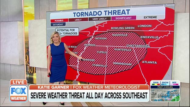
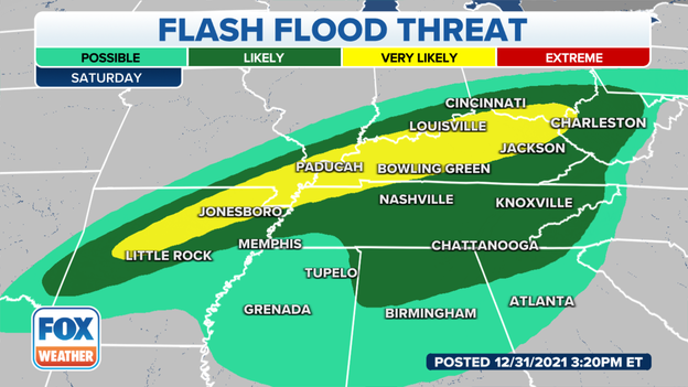
In addition to the severe weather, flash flooding is a major concern, with the greatest threat from Arkansas through eastern Kentucky.
Storms will likely track over the same areas dropping as much as 2-5“ of rain in a short time. This will lead to widespread instances of flash flooding as well as river flooding even after the rain ends.
Heavy rainfall threat
Meteorologists are watching areas from Arkansas to Ohio for the potential of flash flooding. Thunderstorms are expected to continue through sunrise and produce torrential rainfall.
Forecast models show many areas receiving between 1 - 3 inches of rain with locally higher amounts.
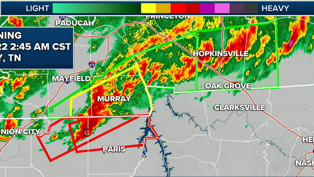
Radar monitoring severe thunderstorms along the Kentucky-Tennessee line
Doppler radar indicated rotation in a storm north of Paris, Tennessee around 2 a.m. CDT. Weakley and Henry counties were placed under a Tornado Warning. In addition to the tornado threat, the storm was capable of producing torrential rainfall.
A Tornado Warning has been issued for Weakley and Henry counties in northwestern Tennessee. The storm is moving to the northeast at around 50 mph.
Areas in the path of the storm include: Martin, Dresden, Cottage Grove, Latham, Palmersville, Puryear, Matheny Grove, Hyndsver, Jones Mill, Ruthville, Crossland, Ralston, Mill Creek, Brundige, Pisgah, Conyersville and Foundry Hill.
Track the storm on FOX Weather 3D Radar: CLICK HERE
Thunderstorms across northern Arkansas are training over some of the same areas. This means the storms are producing tremendous rainfall and leading to flash flooding. Rainfall of more than 2 inches has been reported with at least 2 more inches on the way before sunrise.
7 facts you should know about flash floods: CLICK HERE
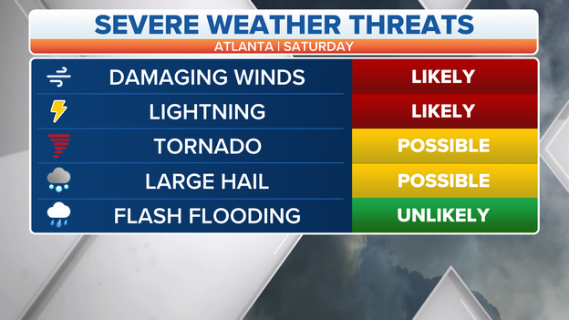
North Georgia Weather Threats
Thunderstorms with damaging winds and lightning will be likely late Saturday in northern Georgia. Areas north of the Atlanta-metro are under an enhanced risk for seeing severe thunderstorms.
The storms will be the second round of severe weather within 24 hours for the Peach State: READ MORE

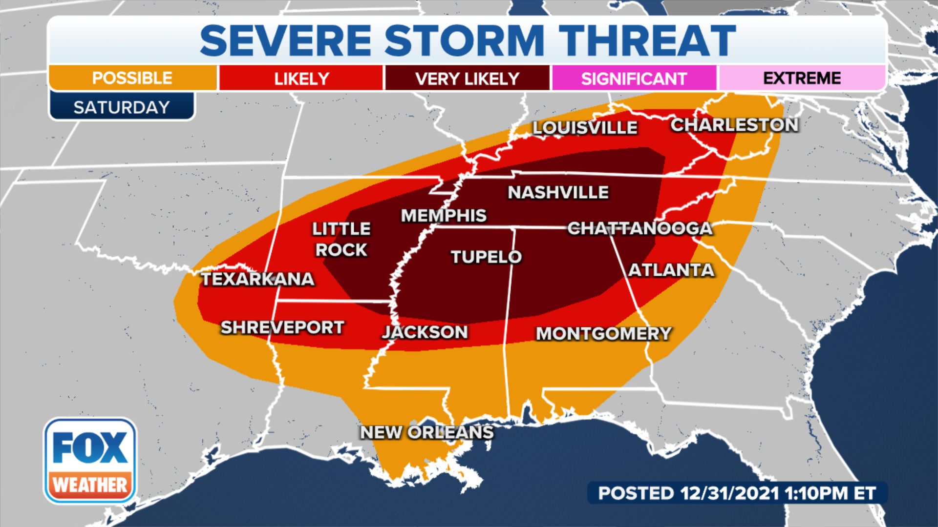
Severe weather threat zone
Nearly 30 million Americans are under a severe weather threat on New Year’s Day for the potential of thunderstorms producing large hail, damaging winds and tornadoes.
Storms are developing across Arkansas and the Tennessee Valley and will slowly head eastward, where the atmosphere is more prime for development.
A Severe Thunderstorm Watch and a Tornado Watch are in effect for the parts of the region until around sunrise.
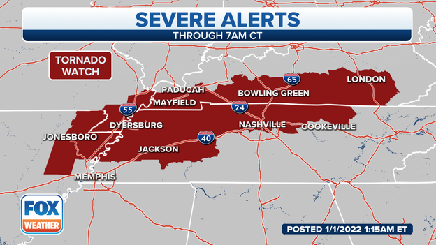
Saturday Tornado Watch
More than 3.3 million residents across four states are under a Tornado Watch until 7 a.m. CDT. Meteorologists say strong to severe thunderstorms are expected to develop and move into the region before sunrise.
A Tornado Watch means conditions are favorable for twisters in and close to the watch area.
What you should do to prepare for tornadoes: CLICK HERE
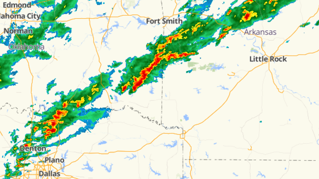
Radar of heavy rains over the South
Doppler radar indicates storms over eastern Oklahoma and western Arkansas are producing rains of 1 to 2 inches per hour. Additional rainfall is likely over the next few hours and localized flash flooding could occur.
A Flash Flood Warning is in effect for Yell, Logan, Polk and Scott counties in Arkansas.
7 Facts you should know about flash floods: CLICK HERE
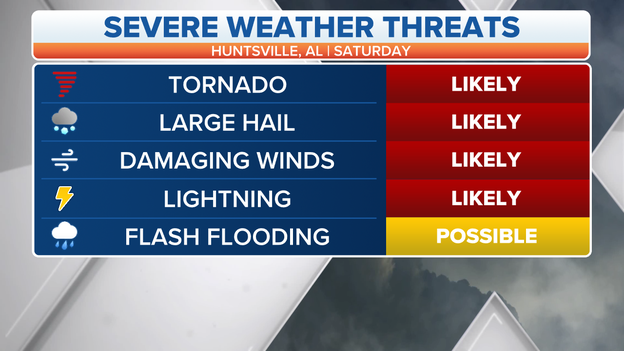
Severe weather threat for Alabama
Several modes of severe weather are likely in northern Alabama later on Saturday. Tornadoes, hail, damaging winds, lightning and heavy rains will all be possible ahead of significant cold front.
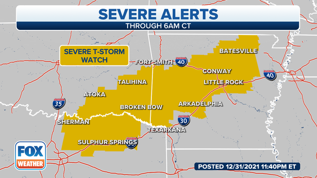
Severe thunderstorm watch box
The Storm Prediction Center issued a Severe Thunderstorm Watch for areas of Texas, Oklahoma and Arkansas until 6 a.m. CDT.
Meteorologists warn damaging wind gusts to 70 mph, large hail and an isolated tornado is possible during the overnight hours.
Strong to severe thunderstorms are expected to continue to develop and strengthen as the storm system works its way eastward.
Download the FOX Weather app now to track the storms.

Live Coverage begins here