Live updates: Dangerous winter storm blasts the South as power outages skyrocket
Live updates: Dangerous winter storm blasts the South as power outages skyrocket
Download the AppLIVE Winter Storm HQ coverage continues
View postCoverage for this event has ended.
LIVE coverage has ended here, but FOX Weather is providing 24-7 updates all day and night to help keep you and your family safe.
Oxford Utilities, the City of Oxford’s community-owned electric, water and sewer utility ceased operations early Sunday morning due to unsafe working conditions. The company reported falling and "popping" trees as more than 80,000 power outages have been reported across Mississippi, according to poweroutage.com.
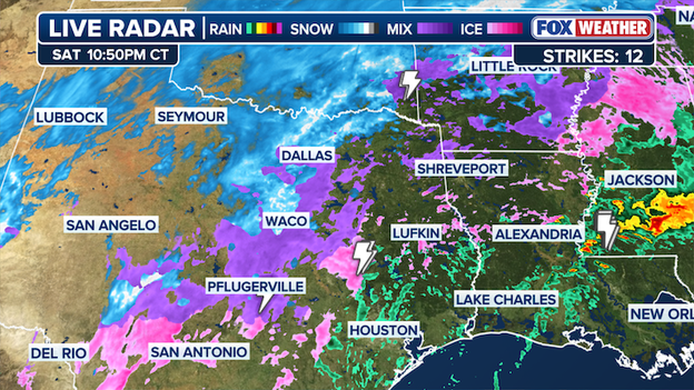
FOX Weather Live Radar tracker.
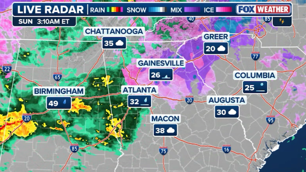
Freezing rain has arrived in Atlanta as the major winter storm continues to barrel through the Southeast.
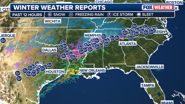
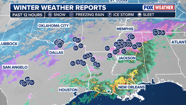
Winter Weather reports from the FOX Forecast Center.
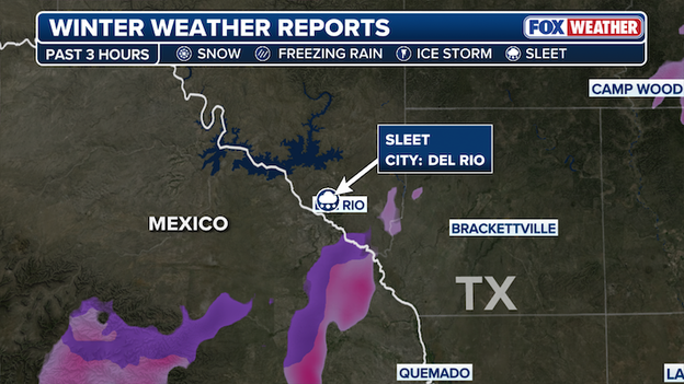
Sleet has been reported in the city if Del Rio in Southwestern Texas just miles from the US-Mexico border.
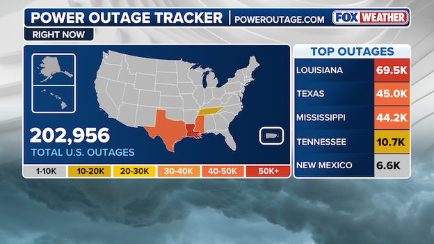
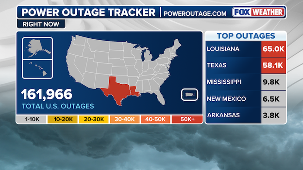
Power Outage Tracker using data from poweroutage.com
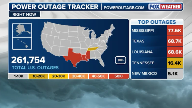
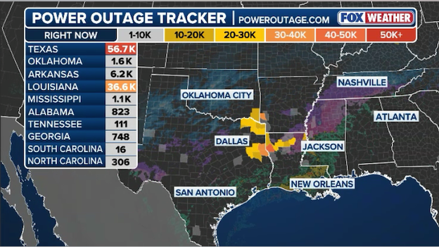
Power outages continue to increase, as more than a quarter million Americans are without power as crippling ice storms and dangerous winter weather continue to slam the South. According to data from poweroutage.com, more than 75,000 outages have been reported in Mississippi, and reports in Louisiana and Texas are both total more than 65,000 power outages.
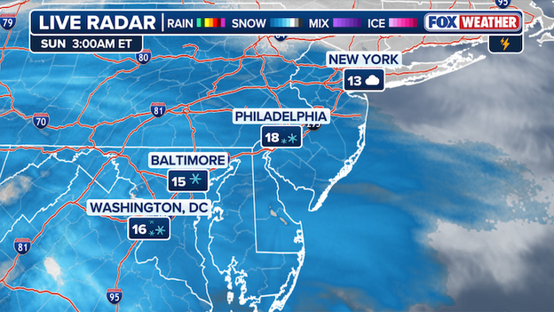
Live radar captures snow in Washington, DC, Baltimore and Philadelphia.
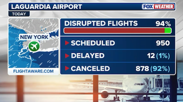
LaGuardia Airport is seeing 94% of flights disrupted due to the winter storm.
Nearly all of the flights coming into and out of LaGuardia Airport in New York are either delayed or canceled.
John F. Kennedy International Airport and Newark Liberty International Airport are also seeing major travel impacts, with over 80% of flights disrupted, according to FlightAware.
Oklahoma City recorded a new daily snow record of 4.4 inches of snow at Gage Airport, surpassing the previous record set in 1948 when 4.0 inches fell. The airport also recorded a temperature of 4 degrees, the fifth coldest temperature on record at Oklahoma City airport.
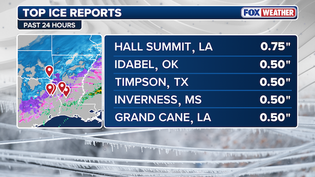
Latest top ice accretion reports across the U.S. over the past 24 hours.
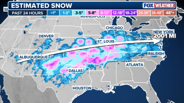
Estimated snow totals across the U.S. in the past 24 hours.
Over 2,000 miles of accumulating snow has been reported stretching across the Southern Tier of the Lower 48 from Arizona to Maryland. The immense storm packs a daunting 2,300-mile-long winter weather footprint that was on display Saturday and will continue to bring heavy snow and dangerous ice to millions of Americans Sunday.
Power outage tracker courtesy of poweroutage.com
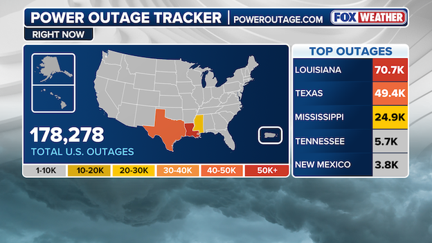
Power outages across the US are rapidly climbing and have exceeded 200,000. Data from poweroutage.com displays widespread outages in Louisiana, Mississippi and Texas, with numbers rapidly growing in both Tennessee and New Mexico.
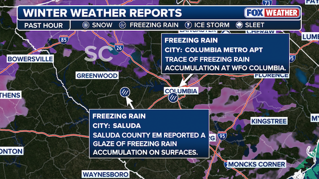
Winter Weather reports in the past hour near Columbia, South Carolina.
Freezing rain is being reported across Columbia, South Carolina. Accumulation has been reported in two separate locations across U.S., though there has been no reported uptick in power outages in the area just yet.
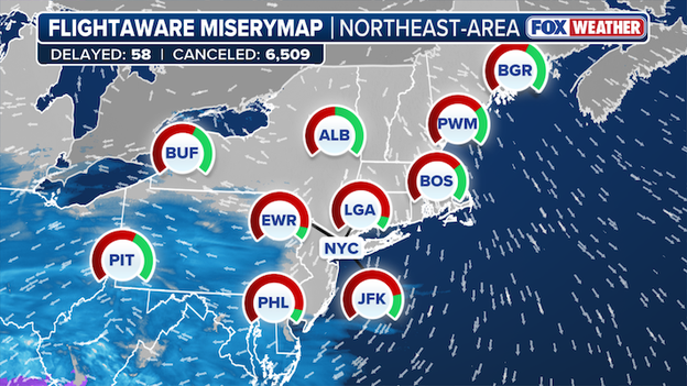
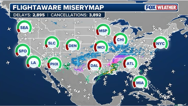
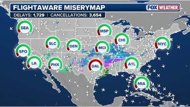
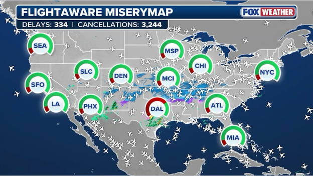
FlightAware MiseryMap showing significant disruptions across the United States on Sunday.
Date from Flightaware shows nearly 70% of all flight cancellations for the U.S. are across the Northeast. Flight cancelations on Sunday surpassed 6,500 as the historic winter storm begins to make its way into the region.
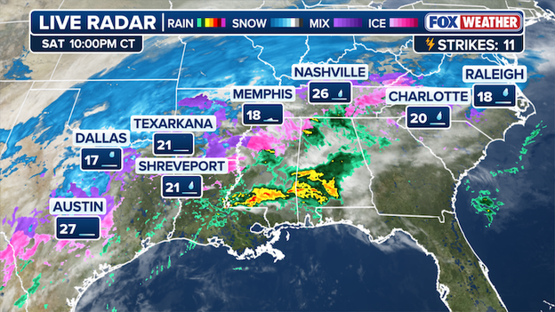
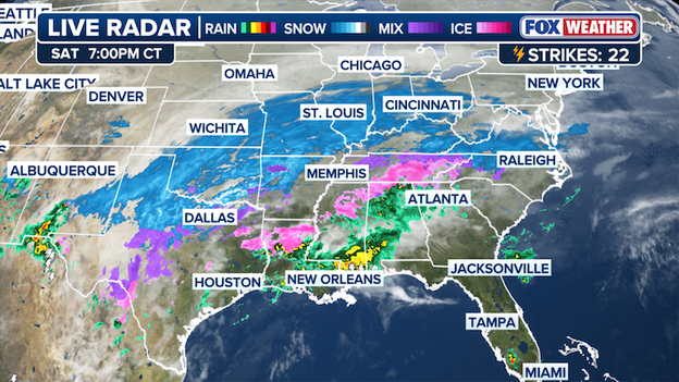
Freezing rain and frigid temperatures recorded Saturday night across cities in the South.
Numerous major cities across the South recorded freezing rain tonight. Raleigh, Charlotte, Memphis, Nashville all the way down to Dallas and Austin saw freezing rain Saturday night, showcasing the sheer size of the historic winter storm delivering harsh winter weather to millions of Americans. If the threat of accretion wasn't enough, many of the cities impacted are facing temperatures in the teens and low 20s.
Power outage tracker using data from poweroutage.com
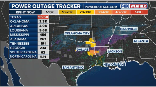
Power outages continue to grow as harsh winter weather lashes the South. Louisiana is at the top of the list of outages according to data from poweroutage.com, exceeding 70,000 across the state. In the past several hours, Mississippi climbed above 20,000 outages and Texas remains crippled with just under 50,000 outages.
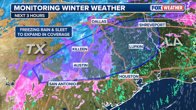
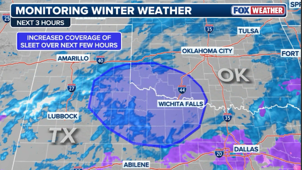
Freezing rain and sleet to expand in coverage in parts of Texas into Louisiana.
The FOX Forecast Center is monitoring a growing risk of freezing rain accretion into early Sunday morning across a corridor stretching from Central Texas into western Louisiana, especially in areas north and along the Interstate-10 corridor.
Fort Worth Police Chief Eddie Garcia announced the Fort Worth Police Department responded to more than 150 weather-related calls on Saturday from Midnight to 8 pm. The department was kept busy as a strong winter storm lashed the region. Officers assisted stranded motorists, responded to traffic accidents and more throughout the Lone Star State's rare, ongoing bout with harsh winter weather.
The FOX Forecast Center is monitoring thunder sleet in the South.
Thunder sleet has been reported in Texas and Oklahoma.
There has been 100 report of ice across 11 states in the past 12 hours.

Snow has been reported in Washington D.C.
Snow has arrived in Washington D.C. as the immense winter weather footprint of the historic storm continues to charge east.
Latest power outage tracker map showing outages in the U.S. (PowerOutage.com)
More than 160,000 power outages have been reported in the US. Data from poweroutage.com shows the majority of the outages are in Louisiana and Texas as extreme winter weather continues to hammer the region.
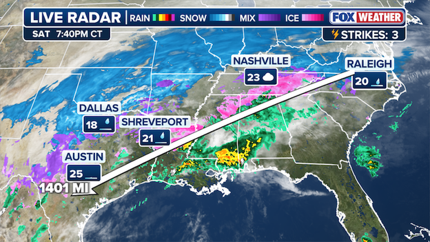
A more than 1,400-mile swath of freezing rain has taken hold, stretching across the South.
Freezing rain is happening across a 1,400 mile swath from Raleigh, North Carolina to Nashville, and into Dallas and Austin, Texas.
Several multi-vehicle pileups occurred in the U.S. on Saturday, as the major winter storm rolling through the parts of the South has lead to extremely dangerous travel conditions for millions.
Read more on winter weather travel accidents in the U.S. here.
Do not risk your life and the lives of others.
Connecticut Governor Ned Lamont declared a State of Emergency ahead of the major winter storm forecast to slam the state this weekend, becoming the 21st state to do so ahead of the historic storm. Declaring a state of emergency provides the governor with the authority to take certain actions necessary to protect public safety during emergency situations, such as the implementation of vehicular restrictions on state roads. Governor Lamont urged Connecticut residents to stay off the roads ahead of a winter storm expected to create dangerous travel conditions statewide.
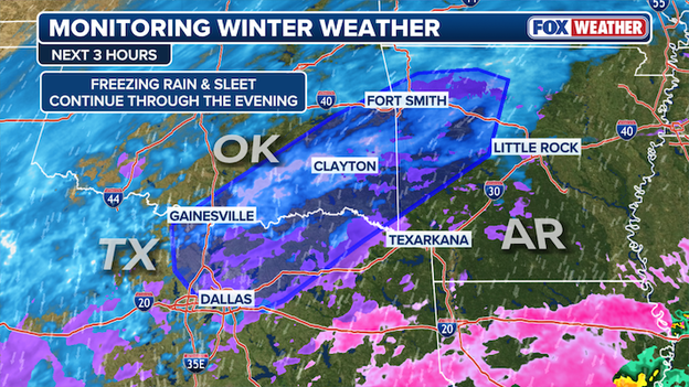
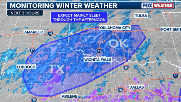
Radar imagery showing freezing rain and sleet across a corridor that includes parts of Texas, Oklahoma and Arkansas.
The FOX Forecast Center is monitoring the threat of freezing rain and sleet across a corridor that includes parts of Texas, Oklahoma and Arkansas. Sleet appears to remain in the forecast into the evening, with a possibility that affected areas see sleet accumulations around 0.10-0.50 inches per hour. There is a lesser threat for freezing rain, though it is still impactful.
The massive storm moves across the U.S. on Saturday.
The massive winter storm is now extending across a 2,000-mile path and it's impacting 20 states from New Mexico to the East Coast.
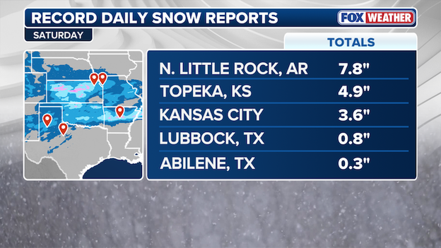
Daily record snow reports in parts of Arkansas, Kansas and Texas on Saturday.
As a historic winter storm impacts several states, parts of Arkansas, Kansas and Texas have seen record daily snow reports today.
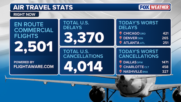
This graphic shows air travel stats courtesy of FlightAware right now in the U.S.
A staggering 15,000 U.S. commercial flights have been canceled by America's massive winter storm through Monday, with another 8,792 flights delayed. Cancelations and delays are mounting today, data from FlightAware shows over 1,400 cancelations at Dallas (DFW) and over 400 delays at Chicago O'Hare International Airport.
Governor Mike Braun has declared a State of Emergency for Indiana ahead the anticipated arrival of the major winter storm, forecast to bring significant snowfall, extremely cold temperatures and hazardous travel conditions to the state. The emergency declaration brings the state of emergency total to 20 across the US.
Winter weather reports in the past hours in the South.
Over the past 12 hours, more than 50 reports of freezing rain have been recorded across 6 states, with the majority of the reports for ice accretion of 0.10 inches of more.
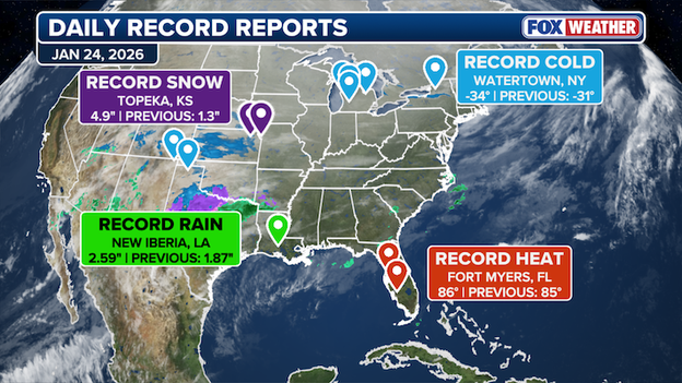
Four daily record reports were recorded on January, 24.
Daily records in snow, rain, cold and heat occurred on January 24, 2026 in four locations across the US. The major winter storm dumped 4.9 inches of snow in Topeka, Kansas and record rain fell in New Iberia, Louisiana. Floridians and vacationers in Fort Myers are arguably the winners of today with temperatures clocked at 86 degrees. In Upstate New York, temperatures sunk to -34 degrees for yet another daily record.
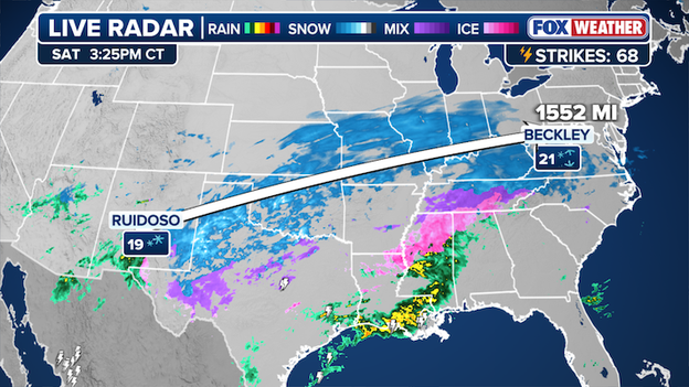
Snow is being reported 1,500 miles apart, from New Mexico to West Virginia.
Ruidoso, New Mexico, and Beckley, West Virginia, two locations more than 1,500 miles apart, are currently reporting snow from this storm.

Power outages have skyrocketed across Louisiana in the past few hours. (PowerOutage.com)
Thousands of people across northern Louisiana are now without power as freezing rain and ice coat the state. Data from PowerOutage.com shows the number of people without power has skyrocketed this afternoon with more than 50,000 energy customers now without electricity.
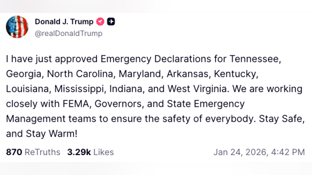
President Trump posted on Truth Social that he has approved Emergency Declarations for 10 states.
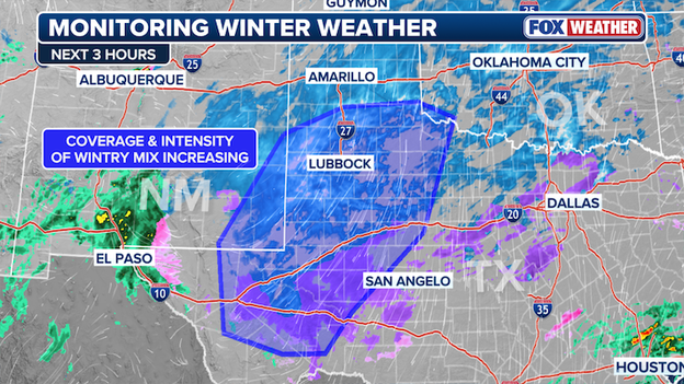
Radar image showing wintry weather threat increasing near Lubbock, Texas.
The FOX Forecast Center is monitoring the threat for wintry weather across West Texas this afternoon. Right now, radar shows snow and ice becoming more widespread near Lubbock and surrounding areas. That intensity is expected to increase over the coming hours which could make driving dangerous.
FlightAware MiseryMap showing significant disruptions across the United States on Saturday.
There's misery on the map this afternoon thanks to America's colossal winter storm. Data from FlightAware shows more than 23,000 U.S. flights have been delayed or canceled through Monday.
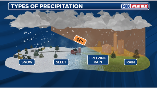
Cross-section of the atmosphere showing how snow, sleet, freezing rain, and rain form.
You've probably read or heard about freezing rain and sleet this weekend - but what are they? Rain occurs when temperatures are above freezing throughout most of the atmosphere. Rain sometimes even starts off as snow and then melts on the way down if there's enough warm air in the atmosphere.
Freezing rain = ice. This occurs when rain falls through the atmosphere and freezes immediately on hitting the ground. Ice begins to accrete on just about everything and can make travel treacherous. Just a few hundredths of an inch of ice is enough to make roads slick. Once you get a quarter to half inch of ice building up, you're talking tree damage and power outages as the weight of the ice pulls down branches and power lines.
Sleet starts with a snowflake. Those snowflakes fall into a layer of warm air sitting above the surface of the earth and start melting. But then they fall into another layer of air that is below freezing and start to refreeze again. These ice pellets bounce when they hit the ground and can be quite loud when there's a lot of them hitting at once.
FOX Weather is tracking all four types of precipitation falling right now as the extreme winter storm wallops the nation.
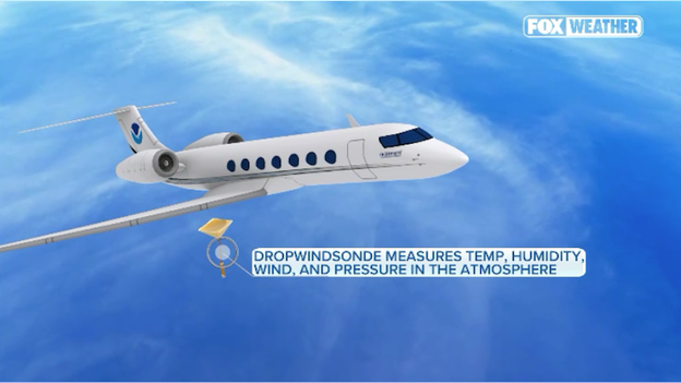
NOAA Gulfstream IV jet flies over storms and gathers data on the state of the atmosphere.
NOAA's Hurricane Hunters are en route to investigate the massive winter storm and provide vital data that will help improve computer forecast models. A NOAA Gulfstream IV just took off from its base in Lakeland, Florida. It's flying over the Gulf of Mexico to get a better idea of how the atmosphere is shaping up as warm, moist air fuels America's winter storm. The data it collects will be fed directly into the powerful supercomputers that produce weather forecast models. The added data has been been proven to increase forecast accuracy.
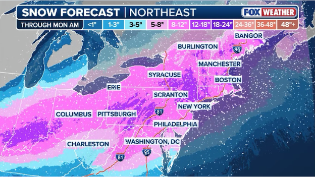
Latest snow forecast from FOX Weather showing widespread heavy snow hitting the Northeast through Monday.
FOX Weather's snow forecast remains on track, and that means a whole lot of snow is headed for millions of Americans along Interstate 95. The latest snow forecast from the FOX Forecast Center shows more than a foot of snow is expected to fall throughout the region.
New York is preparing for up to a foot of snow to fall starting late Saturday night and ending on Monday. Philadelphia and Washington are also gearing up for at least a half foot of snow to fall with a mix of sleet at times, too. And Boston is bracing for up to a foot and a half of snow out of this major winter storm.
Latest power outage tracker showing numerous outages in the Ark-La-Tex region. (PowerOutage.com)
Extreme winter weather is slamming the South and things are only going to get worse tonight. Data from PowerOutage.com shows the number of energy customers without power continues to climb. Nearly 60,000 customers are without electricity right now in Texas and more than 40,000 customers don't have power in Louisiana.
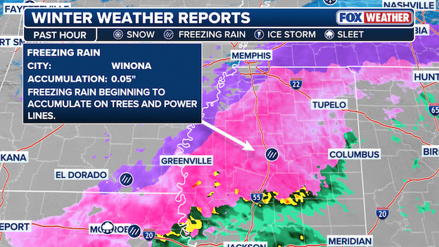
Winter weather report showing ice accumulating in Winona, Mississippi.
The FOX Forecast Center says things are about to get much worse across Mississippi as freezing rain kicks into high gear. That freezing rain is expected to continue through the afternoon, tonight, and into Sunday. Significant icing will make travel nearly impossible and could trigger widespread, long-lasting power outages.
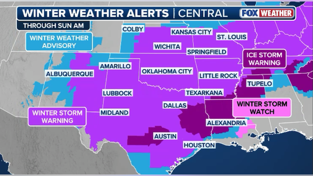
Winter weather alerts span across the Southern Plains with new Ice Storm Warnings in Texas.
The National Weather Service in San Antonio has issued an Ice Storm Warning for Austin, Texas and the surrounding Hill Country. More freezing rain is expected in this area than originally expected, prompting the new warning. The new forecast calls for up to a half inch of ice to accumulate. Roads, and especially bridges and overpasses, will likely become slick and hazardous, making travel nearly impossible. This will also increase the threat of power outages due to the weight of the ice on power lines.
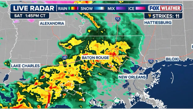
Radar showing heavy rain and thunderstorms tracking toward New Orleans, Louisiana.
While the northern part of Louisiana is dealing with freezing rain and sleet, the southern half is seeing torrential rain and thunderstorms. Radar shows a large cluster of storms inching toward New Orleans at this hour, with Baton Rouge already getting in on the heavy rain and lightning.
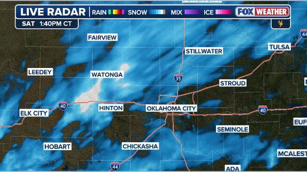
Radar showing snow intensifying in and around Oklahoma City at this hour.
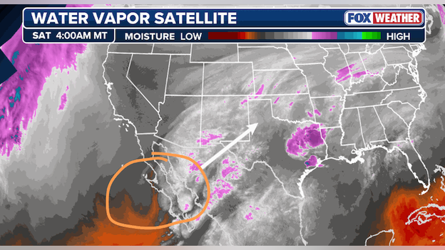
Water vapor satellite image showing the upper-level low spinning toward the Southwest U.S.
Oklahomans woke up to a couple inches of snow this morning and even more is on the way. Phase 2 of the storm is just beginning across the Sooner State. After a relative lull in the snow over the past few hours, the radar is filling in once again.
Moderate snow is being reported at Will Rodgers Airport in Oklahoma City and in Enid, OK. This comes as large-scale lift in the atmosphere increases over the region as an upper-level low barrels toward the Southwest U.S.
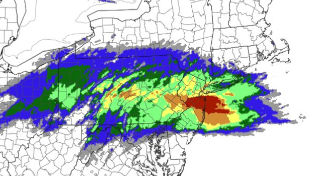
Probability of snow rates exceeding 1 inch per hour in the Northeast around midday Sunday.
New York and Philadelphia are bracing for the most snow they've seen in years and it just might come in a hurry. The FOX Forecast Center says extreme "frontogenesis" could create whiteout conditions along Interstate 95 on Sunday.
Frontogenesis is the process by which warm, moist air slams into cold air arctic, resulting in rising air, fueling intense snow rates. This area of frontogensis is expected to slide north along I-95 on Sunday, triggering extreme snow rates of 2-3 inches per hour along the I-95 corridor. Winter weather experts call it a "snow thump" because it hits quick and lays down significant snow in just an hour or two.
It's this "thump" of snow that is expected to deliver higher totals on Sunday around midday. As the day goes on and that warmer air continues to surge north, the snow may mix with sleet as warmer air moves in aloft, partially melting snowflakes as they fall.
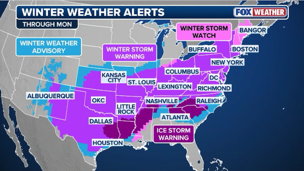
Winter weather alerts span from the Desert Southwest all the way to Maine.
Snow, freezing rain, and sleet are now slicing across the South on a 2,300+ mile journey toward the East Coast. More than 190 million people are under some type of winter weather alert, breaking the record for the most number of U.S. counties simultaneously under a Winter Storm Warning. Stay here throughout the day for the most comprehensive and up-to-the-minute weather news as the storm treks east.

Radar image showing where freezing rain and sleet are expected across Mississippi, Alabama, and Tennessee this afternoon.
The FOX Forecast Center says the threat of significant ice is on the rise right now. Meteorologists are monitoring an area stretching from northern Mississippi to the southern Appalachians where freezing rain, mixed with sleet at times, is expected to become more widespread throughout the afternoon.
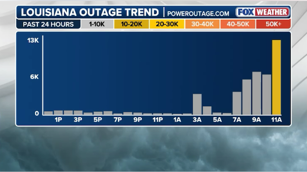
Power outage trend for Lousiana over the past 24 hours. (PowerOutage.com)
The number of people without power across Louisiana is increasing rapidly this afternoon. Data from PowerOutage.com shows more than 20,000 customers are now without power, mostly in the northern part of the state. This is a huge jump over the past hour as freezing rain and sleet slam the region.
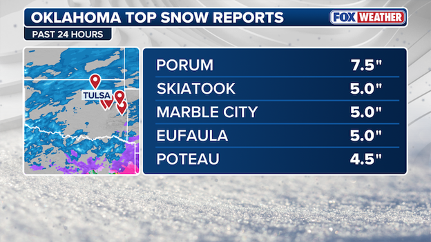
Latest top snow totals from across Oklahoma
We're expecting the roads to be treacherous in some places, and if you crash, first responders may not be able to get to you quickly.
Ohio Governor Mike DeWine has declared a State of Emergency just as snow and ice approach the state. The proclamation directs state agencies, including the Ohio Emergency Management Agency, Ohio State Highway Patrol, and Ohio Department of Transportation, to provide additional resources and support to local communities as needed.
Latest power outage tracker showing county-by-county outages across the South. (PowerOutage.com)
America's colossal winter storm is causing big problems for utility crews - and things are only expected to get worse. Right now, data from PowerOutage.com shows more than 100,000 U.S. energy customers are now without power. This as life-threatening cold air sweeps across the nation. Texas is seeing the worst outages right now with heavy snow, freezing rain, and sleet pounding parts of the state.
FlightAware MiseryMap shows total flight disruptions across the U.S. as the winter storm bears down on 40 states.
A staggering 20,000 U.S. commercial flights have now either been delayed or canceled by America's massive winter storm. That number includes more than 13,000 flights have airlines have been forced to cancel, with another 6,918 flights delayed.
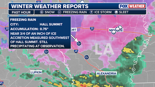
Winter weather report showing nearly .75" of ice measure in Hall Summit, Louisiana.
Radar image showing an area of mostly sleet covering North Texas into Oklahoma.
The FOX Forecast Center says sleet will continue northeast across North Texas into Oklahoma through the afternoon. Sleet of 0.1 to 0.2 inches per hour and some snow rates of 0.5 to 1 inch per hour are possible within the heavier showers from Northwest Texas into central Oklahoma through the afternoon.
The Midcontinent Independent System Operator (MISO), the regional grid operator in the Midwest, has informed Midwest energy companies, including Ameren, that customers in the region need to conserve electricity until further notice due to high demand and weather conditions.
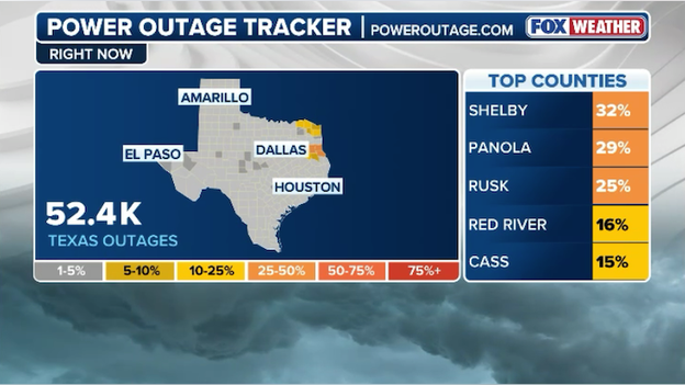
Latest power outage tracker showing outages across Texas. (PowerOutage.com)
With extreme winter weather hammering Texas this morning, power outages are increasing at this hour. More than 50,000 energy customers are now without power, according to PowerOutage.com.
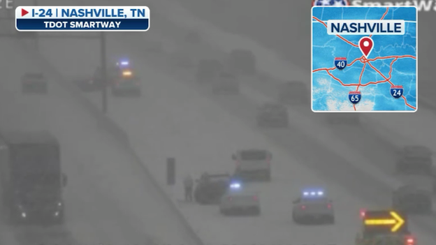
Tennessee Department of Transportation camera along Interstate 24 in Nashville, TN.
Emergency responders are working multiple crashes and slideoffs across several states right now. The Tennessee Department of Transportation camera along Interstate 24 in Nashville, Tennessee shows crews working an accident with snow piling up quickly.
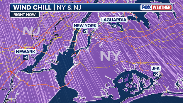
Current wind chill temperatures across New York City.
The FOX Forecast Center says the temperature dropped to a low of 9°F in New York City's Central Park early Saturday, making it the coldest morning at New York City's official climate site in nearly 3 years. The last time temperatures dipped below 10° in the park was on February 4, 2023.
And it's not getting much warmer - wind chill temperatures at this hour remain below zero.
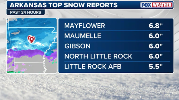
Arkansas' top snow totals so far from the FOX Forecast Center.
Radar analysis showing an area of sleet approaching Nashville, Tennessee.
A look at the pictures out of Nashville, Tennessee may have you thinking that things are okay - it's just snow. But a big change is coming, and it's not good.
The FOX Forecast Center is analyzing radar data, specifically Correlation Coefficient, which can help meteorologists discern different types of wintry precipitation. Current radar shows the sleet line (circled area on the map) creeping north. Meteorologists say it will continue to push north through the afternoon, and Nashville will see its snow change to sleet and then very quickly freezing rain thereafter.
Tonight, a full-blown ice storm will hit the city. FOX Weather expects up to 3/4" of ice. That will be crippling on its own, but to fall on 2-4" of snow is even worse. Tonight's freezing rain will freeze instantly on the snow and make it even harder to clear. And the weight of that ice will weigh down trees and power lines, leading to widespread power outages.
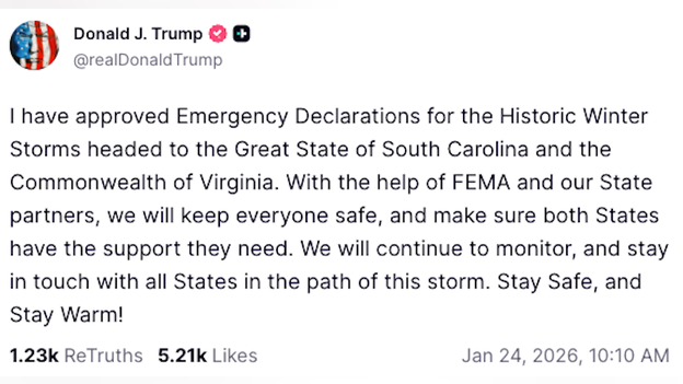
Truth Social post from President Trump.
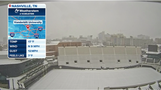
Weatherstem camera at Vanderbilt University showing the snow blanketing the field.
Snow is racing eastward this morning and now Nashville, Tennessee is getting in on the massive winter storm. The Weatherstem camera at Vanderbilt University shows the snow starting to add up. While it's mostly snow now, freezing rain and sleet are expected to mix in later.
"I can tell you, this is really a once-in-a-lifetime kind of day where it's this cold."
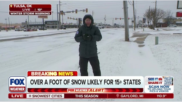
FOX Weather Storm Specialist Mike Seidel reporting LIVE in Tulsa, Oklahoma.
As if the snow and ice weren't enough, life-threatening cold air has invaded America's Heartland. FOX Weather Storm Specialist Mike Seidel is LIVE in Tulsa, Oklahoma right now where the wind chill is -5°F.
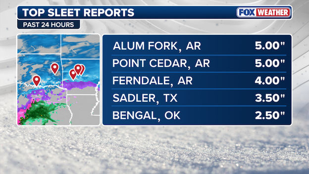
Latest top sleet reports from Arkansas, Texas, and Oklahoma.

Radar map showing where significant freezing rain and sleet are expected across the Ark-La-Tex this morning.
The FOX Forecast Center is closely monitoring an area extending from northern Louisiana into southern Arkansas and western Mississippi for intense winter weather. Heavy freezing rain is now falling in this region with some sleet mixing in, too. That freezing rain is triggering treacherous travel conditions along I-20 right now and things will only worsen through the day. That ice is also starting to weigh down trees and power lines, which could create power outages as the day goes on.
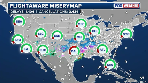
FlightAware MiseryMap showing overall flight disruptions at major U.S. airports.
This is not the weekend for air travel. America's colossal winter storm is wreaking havoc at the airports, triggering thousands of flight delays and cancellations. Since Friday, more than 17,000 U.S. flights have been disrupted. This number includes all flight disruptions through Monday. FlightAware data shows more than 11,000 U.S. flights have been canceled with 6,200+ others delayed.
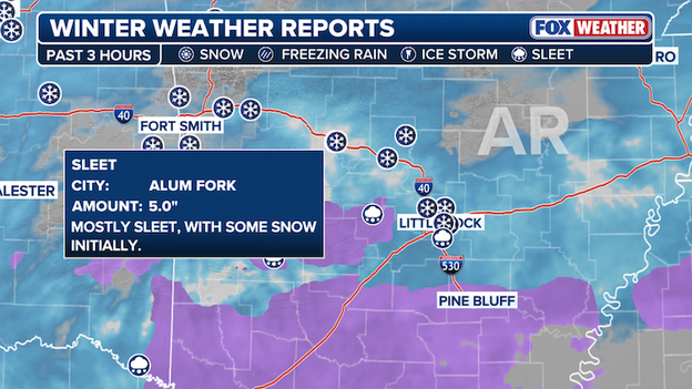
Latest winter weather report from Arkansas showing 5 inches of mostly sleet in Alum Fork, AR.

FOX Weather meteorologists working behind-the-scenes to bring America the most accurate forecast.
Meteorologists at FOX Weather are working around-the-clock to bring you the most accurate weather news and forecasts. FOX Weather is providing LIVE 24/7 coverage through the storm to help keep you safe and informed.
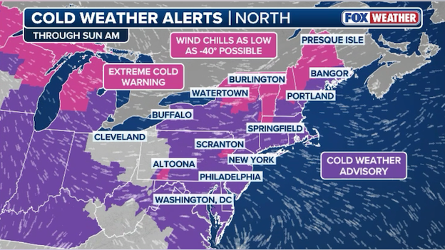
Cold weather alerts cover much of the Northeast, Mid-Atlantic, and Great Lakes.
Arctic air has invaded America and millions are feeling the dangerous cold. Extreme Cold Warnings are in effect for 43 million Americans right now, with 136 million under a Cold Weather Advisory.
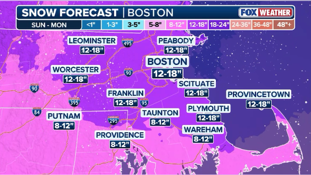
Latest snow forecast from FOX Weather for Boston, Massachusetts through Monday.
Boston is bracing for its biggest snowstorm in years. The FOX Forecast Center is predicting 12-18" of snow will bury much of Massachusetts through early Monday. Forecasters also say that snow totals could be even higher in some spots.
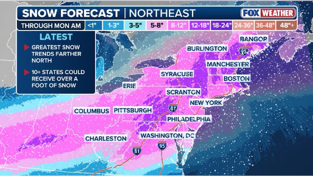
Latest snow forecast for the Northeast and Mid-Atlantic from FOX Weather.
FOX Weather's latest snow forecast is mostly unchanged from Friday. Up to a foot of snow is expected to fall across most of the Northeast. Major cities along Interstate 95 including New York and Philadelphia are expected to see nearly a foot of snow through early Monday. Washington will see slightly less snow due to sleet mixing in with the snow, cutting down on totals. But Boston will bear the brunt of the storm with up to 18" of snow predicted to accumulate.
Sleet and freezing rain are expected to become more widespread this morning over North Texas.
The FOX Forecast Center is monitoring North Texas right now, where an increase in a wintry mix is expected over the coming hours. Sleet is expected to fall with some freezing rain at times, creating dangerous travel conditions throughout the area.
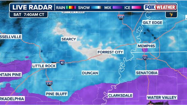
Latest radar showing heavy snow hitting Interstate 40 between Little Rock and Memphis.
Conditions are deteriorating quickly across Arkansas as snow slams the region. Radar shows heavy snow now falling along Interstate 40 between Little Rock, Arkansas and Memphis, Tennessee. Farther south, a wintry mix of freezing rain and sleet is creeping north, which will further worsen driving conditions.
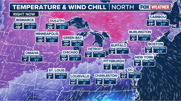
Current temperatures and wind chill temperatures throughout the Northeast and Great Lakes.
Millions of Americans are waking up to frigid temperatures. As if the single-digit air temperatures weren't enough, stiff winds are making it feel much colder. Wind chills are currently near 0°F in New York and approaching -30°F in Chicago. With wind chills this low, frostbite can occur within just 30 minutes to any exposed skin.
Camera showing snow covering the ground in Memphis, Tennessee.
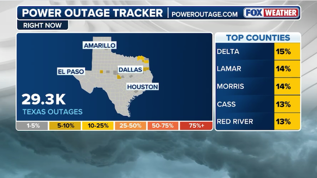
Latest power outage tracker map showing outages in Texas. (PowerOutage.com)
Some Texans are waking up without power this morning. Data from PowerOutage.com shows power outages increasing across Northeast Texas, particularly in Delta, Lamar, and Morris Counties. As of now, more than 29,000 customers are without electricity in the Lone Star State.
The FOX Forecast Center just received a new snow report. 6 inches of snow has been recorded in Little Rock, Arkansas since last night.

Camera showing ice building up on the lens in Texarkana, Arkansas.
While snow is falling in some parts of Arkansas, other areas are seeing freezing rain. This is rain that falls to the ground and freezes upon hitting the surface due to freezing temperatures. Texarkana, AR is just one of the places expected to see significant icing this weekend due to the winter storm. That ice can build up quickly and turn roads into an ice rink, weighing down trees, and pulling down power lines.
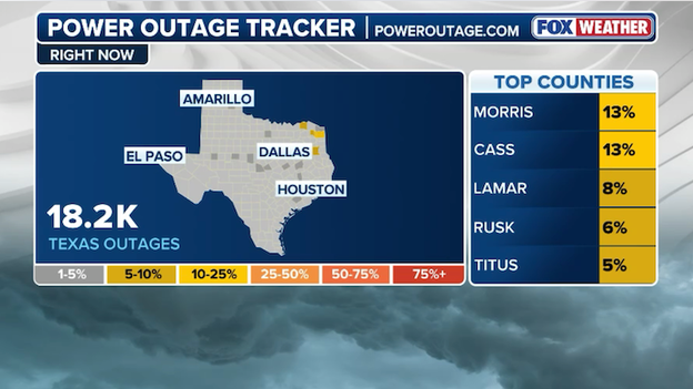
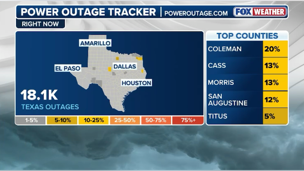
Power outage tracker showing 18,000 customers without power in Texas. (PowerOutage.com)
FOX Weather is closely monitoring power outages as this massive winter storm sweeps across the nation. Right now, PowerOutage.com reports more than 18,000 energy customers are without power in Texas.
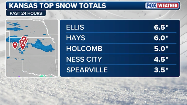
Chart showing the top snow totals from Kansas as of 6 a.m. ET Saturday.
America's massive winter storm is still in its early stages and millions of people will see snow and ice in the next two days.
As of 6 a.m. ET Saturday, Kansas has seen the most snow so far. 6 inches of snow has already been reported near Hays, KS.
Arkansas Department of Transportation camera along Interstate 40 at mile marker 151.
More than 4" of snow has been reported in and around Little Rock, Arkansas this morning. ARDOT cameras show snow-covered roads in the city and throughout central Arkansas.
It's not a great weekend for those taking to the skies. America's colossal winter storm has now forced airlines to cancel more than 10,000 U.S. flights through Monday. If you are planning to fly, double check with your airline to see if your flight is scheduled to takeoff as scheduled. Most of the nation's major air carriers issued travel waivers ahead of the storm, allowing customers to change their flight without paying a change fee.
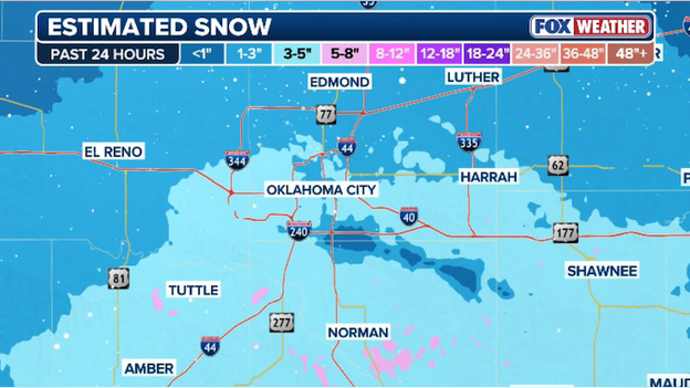
Estimated snow amounts over the past 24 hours in and around Oklahoma City.
Oklahomans are waking up to less snow than expected this morning. Radar estimates only a few inches of snow have fallen overnight in the OKC metro area, less than what was predicted.
The FOX Forecast Center explains suppression is to blame. Frigid air moving in at the surface overwhelmed and suppressed the milder, moist air flowing in above it. This essentially cutoff the firehose of moisture from reaching central Oklahoma.
Forecasters caution that people shouldn't think it's over. A second round of heavier snow is expected to hit the Sooner State later tonight into early Sunday. And things will be different this time around with a more classic winter storm setup allowing for heftier snow totals.
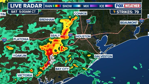
Radar image showing heavy rain and thunderstorms moving into Houston.
While millions of Americans are dealing with the threat of snow and ice, the southern end of this massive storm is producing a different threat: flash flooding. Right now, the FOX Forecast Center is closely monitoring a cluster of thunderstorms that has developed near the Houston metro area. These storms are producing very heavy rain as they approach Houston. Some localized flash flooding could occur as these storms drop up to an inch of rain an hour in some spots.
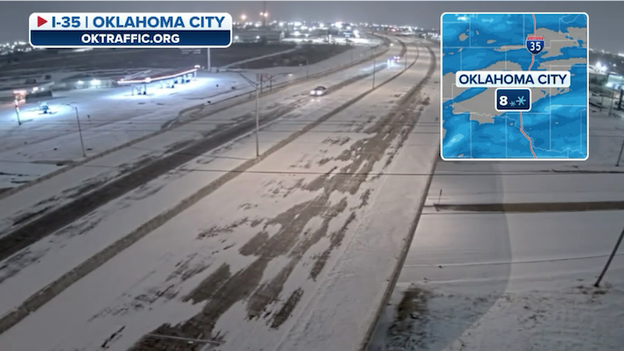
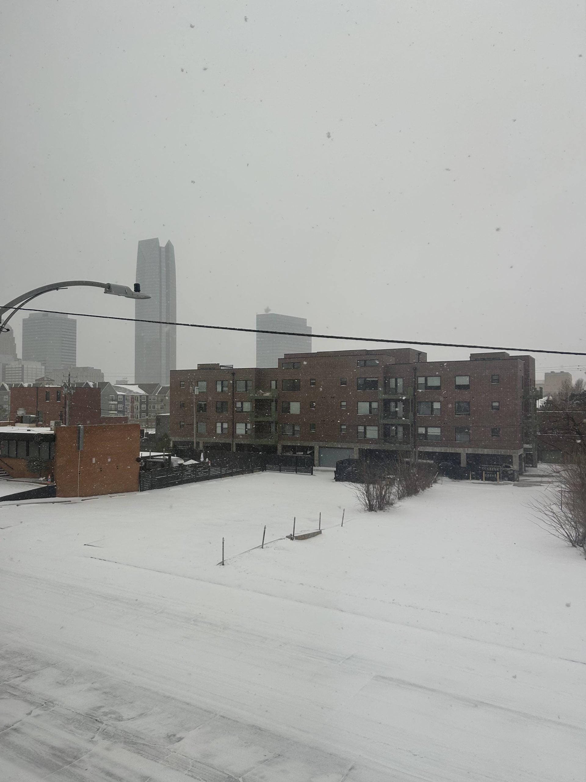
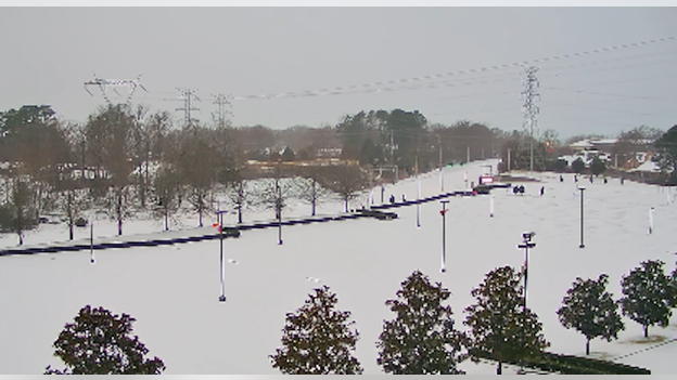
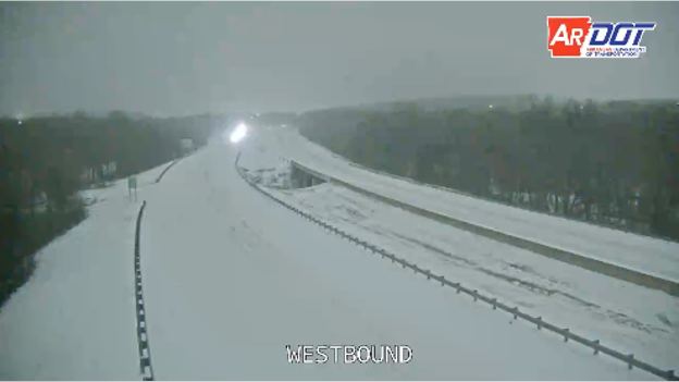
OKTRAFFIC.ORG camera showing snow covering Interstate 35.
Snow is covering the ground this morning in Oklahoma City. An image from OKTRAFFIC.ORG shows snow partially covering I-35 at this hour.
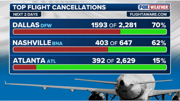
Top flight cancellations by airport over the next two days. (FlightAware)
With Dallas Fort Worth International Airport dealing with dangerous freezing rain and sleet this weekend, airlines have been forced to cancel hundreds of flights. The latest data from FlightAware shows more than 70% of DFW's schedule has been canceled over the next two days.
Latest FlightAware MiseryMap showing significant flight disruptions across America.
Big travel trouble for weekend fliers - FlightAware reports more than 14,800 U.S. flights have now been disrupted by the storm. That number includes nearly 10,000 canceled flights and 5,000 others that have been delayed.
Latest power outage tracker showing current outages in Texas. (Poweroutage.com)
Overnight snow and ice have triggered power outages in parts of the Lone Star State. As of 4 a.m. CT Saturday, more than 18,000 customers were without power.
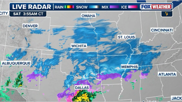
Latest radar image showing snow, freezing rain, and sleet across America's Heartland.
An early morning look at radar shows our winter storm ramping up across the Heartland. Snow is falling from Kansas City to Little Rock, with freezing rain and sleet reported near Dallas. Conditions will continue to deteriorate throughout the morning in these areas as snow and ice build up.
You can go back and see how the forecast for this winter storm has evolved with our live coverage from Friday.
You’ve reached the beginning of this live coverage.