Live updates: Artemis II eyes splashdown as storms flood Florida, severe storms target the Heartland
Live updates: Artemis II eyes splashdown as storms flood Florida, severe storms target the Heartland
Download the AppCSU to release 2026 Atlantic hurricane season outlook
View postCoverage for this event has ended.
We have moved our live coverage to a new blog for Thursday, April 9, as we count down to the official 10:00 a.m. ET release of the Colorado State University 2026 hurricane outlook.
Will the burgeoning "Super El Niño" be enough to suppress the season, or will record Atlantic heat take the lead?
Join us for real-time analysis, the predictions, and reactions from the National Tropical Weather Conference.
FOLLOW TODAY'S UPDATES: CSU to release 2026 hurricane outlook as Super El Niño threatens to upend the season
On the brink of a potentially dangerous severe weather outbreak, FOX Weather is tracking a high-impact threat across the Plains.
Severe Weather Specialist Gabe Garfield joins FOX Weather Meteorologist Ari Sarsalari as nearly 20 million people face the risk of large hail, damaging winds and possible tornadoes — a volatile setup that could intensify quickly from Saturday to Tuesday.
Stay with FOX Weather through the weekend as we track the evolving forecast and monitor storms in real time.
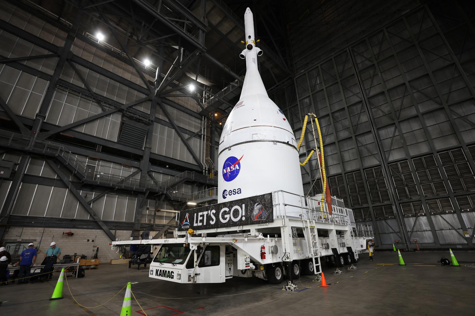
Though the Artemis II crew has traveled farther from Earth than any humans ever, several critical checklist items remain before this historic journey comes to an end.
The immediate next step for Artemis II is reentry and splashdown, widely considered the most dangerous part of the mission.
The splashdown is scheduled for Friday, April 10, 2026, at approximately 8:07 p.m. EST or 5:07 p.m. PST.

View from Orion roughly 180,000 miles from Earth. (NASA)
As Orion hurtles back toward Earth at speeds approaching 25,000 mph, it will slam into the atmosphere and endure temperatures near 5,000 degrees.
This phase is a major test of the spacecraft’s heat shield system — an area NASA has been closely watching since the uncrewed Artemis I mission revealed unexpected cracking and material loss.
Engineers have since adjusted the heat shield design, and Artemis II will be the first real-world test with astronauts onboard. If all goes according to plan, Orion will deploy parachutes and splash down in the Pacific Ocean on Friday.

Earlier, Canadian Prime Minister Mark Carney spoke live with Canadian Space Agency (CSA) astronaut Jeremy Hansen during a space-to-Earth call, marking a moment of national pride as the United States and Canada continue to push the boundaries of human space exploration
The Artemis II Crew made up of Hansen and NASA Astronauts Reid Wiseman, Victor Glover and Christina Koch have traveled further than any humans before them.
Their journey around the moon has been one of firsts, etching the crew into history.

The Artemis II crew connects from deep space
On the Artemis II mission, Hansen became the first Canadian to travel to deep space and around the Moon.
During their conversation, Prime Minister Carney highlighted the significance of Canada’s role in human space exploration and reaffirmed the Government of Canada’s commitment to science, innovation, and international collaboration.

Two years ago today, millions of Americans stepped outside, equipped with eclipse glasses, to witness one of nature’s most extraordinary events.
A total solar eclipse swept from Texas to Maine, turning day into dusk and bringing cities to a standstill. Across the impacted areas, parties were held, crowds cheered and millions marveled at the phenomenon.
Just two days ago, a similar solar eclipse occurred for an audience of just four. The Artemis II crew aboard the Orion spacecraft Integrity on an inspiring journey in deep space had front row seats to the celestial show that just two years ago had millions gazing up.
No crowds, no buildup, just a quiet, fleeting moment experienced by the select four humans that traveled further than any human before them.
Thankfully, cameras allow the rest of us to get a look at the jaw-dropping sight the Artemis II crew experienced.
The powerful image captured by the Artemis II crew is worth a thousand words. Framed by the Orion spacecraft that carried them there, it shows the moon blocking the sun—and, for a moment, hiding the astronauts themselves from the rest of humanity.
Now, those four trailblazers are on their way home, leaving behind view no other humans have ever experienced.

Looking for the latest from the National Hurricane Conference and the AMS Tropical Meteorology Conference?
While we track today's severe storms and the Artemis II return, our team is also on the ground in Texas covering the future of hurricane forecasting.
Catch up on the latest 2026 season outlooks, the National Hurricane Center's forecast changes, and expert analysis on how this year's weather patterns could impact the tropics.
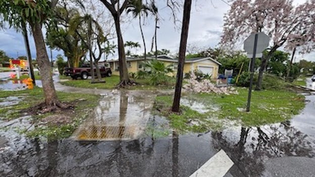
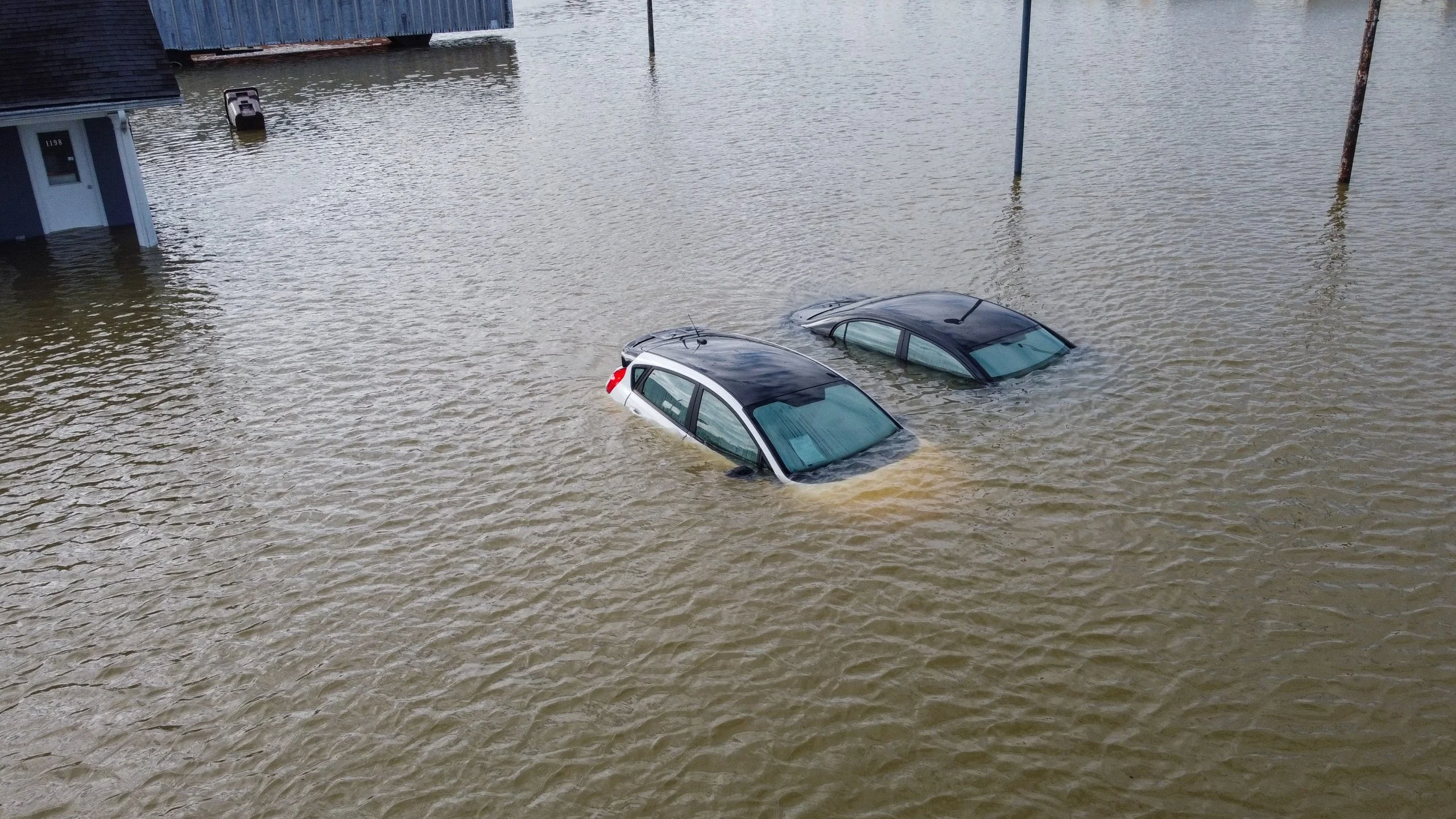
Roads appear flooded after Tuesday's storms in Miami-Dade County.
Fire officials responded to multiple incidents across northern Miami-Dade County on Tuesday involving downed trees, power lines and minor structural damage.
Miami-Dade Fire Rescue is urging the community to stay informed, slow down, never drive through flooded roads and stay away from standing water or downed power lines.
Anyone planning to go to the beach or on a boat is advised to check conditions before heading out. When in doubt, don't go out, fire officials said.
They also say people should only swim at lifeguard-protected beaches and follow warning flags.
Thunderstorms are developing in northern Palm Beach County and are expected to drift south over the next several hours.
The National Weather Service said they are monitoring an urban flood threat as well as a threat for isolated severe storms.
Rainfall totals could reach 2 to 3 inches in a short period of time. The severe storms that do form are expected to bring hail and gusty winds.
A brief tornado cannot be ruled out, the National Weather Service said.
There is an elevated threat across the Miami, Broward and Palm Beach metro areas.
The CEO and founder of Janet’s Planet, Janet Ivey, joins FOX Weather to discuss the latest updates on the Artemis II space mission as the countdown for splashdown begins following a successful launch.
The U.S. Navy has officially joined the final phase of the Artemis II mission as the USS John P. Murtha (LPD 26) departs for the Pacific Ocean.
As the designated primary recovery ship, the San Antonio-class amphibious transport dock is steaming toward the splashdown zone to meet the Orion spacecraft upon its return this Friday.
The ship's crew, alongside NASA recovery specialists and Navy divers, will be responsible for safely retrieving the four astronauts and hauling the 16-foot capsule into the vessel's well deck.
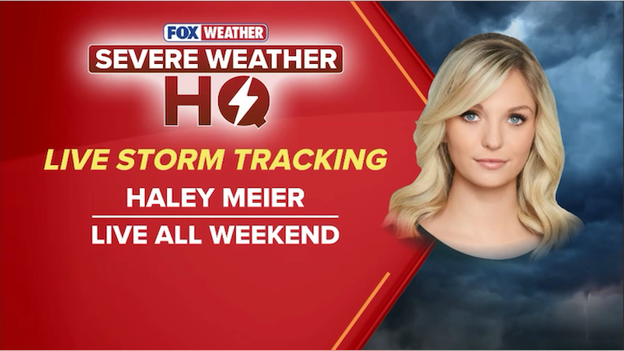
FOX Weather meteorologist Haley Meier is deploying into the storm's path this weekend to provide live reports as severe weather targets the Plains.
FOX Weather will be providing LIVE Storm Tracking all weekend as a dangerous severe weather outbreak threatens millions across the Heartland.
Meteorologist Haley Meier is deploying directly into the storm’s path, providing real-time updates and expert analysis from the field.
She will be joined by veteran exclusive storm trackers Brandon Copic and Corey Gerken, who will be on the ground to capture the first signs of development as tornadoes, massive hail, and destructive winds take aim at the Plains.
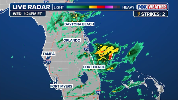
Radar showing showers and thunderstorms increasing across Florida this afternoon.
Radar imagery shows showers and thunderstorms steadily increasing across the Florida Peninsula this afternoon as a deep plume of tropical moisture interacts with a stalled front.
While much of the state is seeing activity, the most intense downpours are currently focused along the Atlantic coast, where rain is falling at rates of 1–2 inches per hour in some areas.
These slow-moving storms are the primary reason a Flood Watch remains in effect through 10 p.m. for the Miami, Fort Lauderdale, and West Palm Beach metros, as the ground is already saturated from previous days of heavy rain.
While much of the country has been focused on the spring thaw and lunar milestones, a significant Pacific storm is taking aim at California this weekend.
According to the FOX Forecast Center, a strong low-pressure system will move into the coast starting Friday night, bringing widespread rain, thunderstorms, and mountain snow through Saturday.
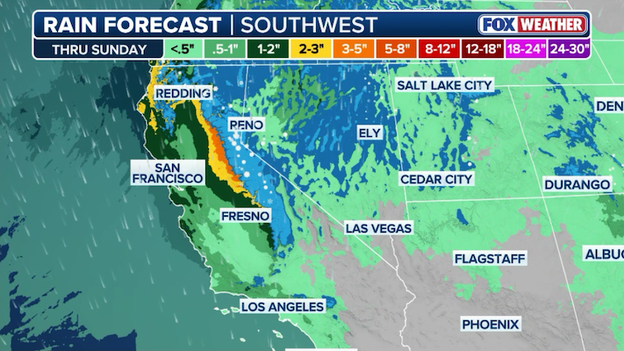
Heavy rain and mountain snow are expected to coat California this weekend as a powerful spring storm slams the region.
This spring soaker is expected to deliver 2-3 inches of rain to many coastal and valley regions, though isolated bursts could push totals higher.
In the mountains, snow levels will drop to between 7,000 and 9,000 feet, potentially coating high-elevation peaks with a fresh late-season layer.
While the rain will help maintain soil moisture, residents are urged to clear gutters now, as gusty winds and slick roads could make for a messy Saturday commute.
On Flight Day 8 of their historic mission, the Artemis II crew is officially Earthbound, waking up more than 200,000 miles away from home to the sounds of "Under Pressure" by Queen and David Bowie.
After successfully exiting the moon's sphere of influence yesterday, Commander Reid Wiseman, Victor Glover, Christina Koch, and Jeremy Hansen are focusing today on critical tests to prepare their bodies and their spacecraft, Integrity, for Friday’s high-speed reentry.

The Artemis II crew – (clockwise from left) Mission Specialist Christina Koch, Mission Specialist Jeremy Hansen, Commander Reid Wiseman, and Pilot Victor Glover – pause for a group photo with their zero gravity indicator “Rise,” inside the Orion spacecraft on their way home. (NASA)
A major priority for the day is testing orthostatic intolerance garments. These specialized compression suits are designed to help the astronauts' blood pressure and circulation adjust as they transition from days of microgravity back into Earth's pull, preventing dizziness or fainting upon splashdown.
Additionally, the crew will perform another manual piloting demonstration late tonight, taking the reins of Orion to practice steering the craft into a tail-to-Sun attitude—a vital maneuver for managing the ship's temperature and power levels during the final leg of the journey.
As the Artemis II crew prepares for their historic return to Earth this Friday, all eyes are on the weather conditions off the coast of San Diego, California.
NASA’s strict recovery criteria require no precipitation or thunderstorms within 35 miles of the site, wave heights under six feet, and winds below 29 mph.
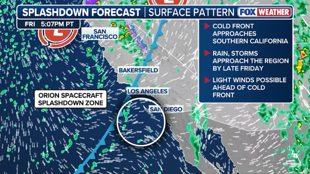
Forecasters are closely monitoring Orion's splashdown zone for possible violations of the strict weather criteria this Friday evening.
While the Pacific is typically calm, the FOX Forecast Center is tracking a low-pressure system and a trailing cold front that could bring rain showers and cloud cover to the splashdown zone at 5:07 p.m. PT.
While winds and waves currently appear favorable, the proximity of the rain remains the wildcard; much like the Artemis I mission, any moisture within the critical zone may force NASA to relocate the recovery operations.
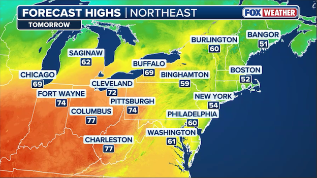
Temperatures are forecast to begin warming up on Thursday across the Northeast.
The stubborn April chill is finally beginning to loosen its grip on the Northeast as a noticeable warming trend takes hold.
After a final round of patchy morning frost, afternoon temperatures across the region are expected to rebound significantly on Thursday under mostly sunny skies.
A shift to southerly winds will help usher in this milder air, setting the stage for even warmer, spring-like conditions—with some areas potentially seeing highs in the 70s—as we head into the weekend.
While rain and flood threats grab the headlines, a invisible and life-threatening danger is lurking at the water's edge today.
A "high" rip current risk is in effect for most of the Atlantic coastline, from the Georgia border down to Miami.
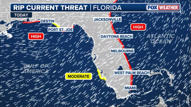
The risk for rip currents remains "high" along the east coast of Florida today.
Powerful northeast winds gusting over 30 mph are churning up the Atlantic, creating gale-force conditions offshore and dangerous surf locally.
Waves along the East Central Florida coast are expected to peak between 8 and 12 feet today, making the surf zone hazardous for even the most experienced swimmers.
Officials are strongly advising beachgoers to stay out of the water, especially in Volusia and Palm Beach counties where the combination of high surf and erosion makes the coastline particularly volatile.

The atmospheric stage is being set for a classic, multi-day severe weather outbreak beginning this weekend as a traditional spring pattern takes hold across the midsection of the country.
After a week of localized flooding and unseasonable chill, a potent upper-level trough digging into the Western U.S. will act as the engine for this next round of high-impact weather.
What’s fueling the threat
The primary driver is a robust southwesterly flow aloft that will pull rich, unstable Gulf moisture northward into the Plains. This setup will create a classic clash of air masses: warm, humid air at the surface overridden by cold, dry air aloft.
Combined with strong wind shear (changing wind speed and direction with height), the atmosphere will be primed to support organized, rotating thunderstorms.
The Threat Zone: Saturday – Tuesday
The bullseye shifts daily as the storm system evolves and pushes eastward:
- Saturday: The opening salvo targets the Southern High Plains, particularly West Texas, where isolated supercells could produce very large hail.
- Sunday: The threat intensifies and expands into Central/North Texas, Oklahoma, and Kansas. Forecast models suggest a mid-level jet could trigger a substantial severe storm threat including tornadoes.
- Monday & Tuesday: The system accelerates, stretching the risk from Texas all the way to the Upper Midwest. Cities like Dallas, Oklahoma City, Kansas City, and St. Louis are currently in the crosshairs for what could be a widespread damaging wind and hail event.
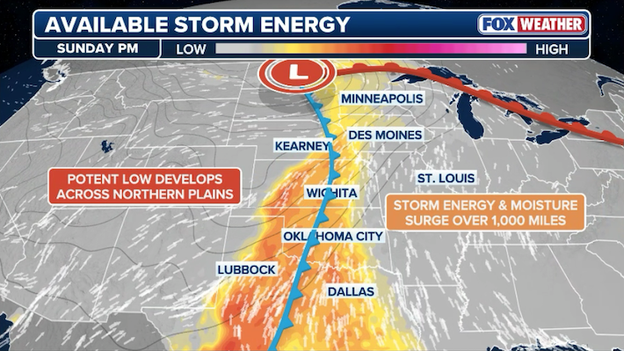
Computer forecast models show widespread instability (the fuel) for thunderstorms to erupt across the Plains on Sunday.
As with any major spring setup, the forecast hinges on critical details:
- Capping: A layer of warm air aloft (the "cap") could prevent storms from firing at all. If the cap holds, the day stays dry; if it breaks, the result is often explosive storm development.
- Timing of the trough: If the main upper-level energy arrives earlier in the day during peak heating, the tornado threat increases. A later arrival might transition the event into a "squall line" of damaging winds and heavy rain overnight.
Mandatory evacuations have been ordered in Larimer County this morning as the Cougar Run Fire burns south of Carter Lake.
The Larimer County Sheriff's Office issued the alert just after 6:00 a.m. local time for residents along County Road 31, while voluntary evacuations are in place for the Berthoud area including Blue Mountain and Spring Valley.
Fire crews are working to contain the blaze amidst elevated fire danger conditions along the Front Range, with officials urging residents in the path of the smoke to remain vigilant.
While the Orion spacecraft is a marvel of engineering designed to withstand the heat of reentry, the final stage of the Artemis II mission depends entirely on Mother Nature cooperating at the finish line.
NASA has established a strict set of weather "Go/No-Go" criteria for the recovery zone to ensure the safety of both the four astronauts and the recovery teams aboard the USS John P. Murtha.
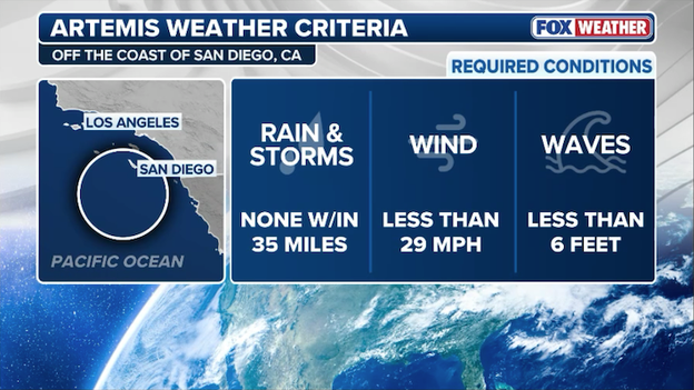
NASA utilizes strict weather criteria for the splashdown recovery zone for the Orion spacecraft.
To proceed with a splashdown, there can be no precipitation or thunderstorms within 30 nautical miles (approx. 35 miles) of the site. Additionally, wind speeds must remain under 25 knots (about 29 mph), and the significant wave height—an average of the highest one-third of waves—must be less than six feet to safely deploy the recovery boats and helicopters.
Forecasters are closely monitoring an approaching storm system on Friday that could produce showers in the recovery zone, forcing NASA to alter the splashdown location.
If you thought the calendar said April, Old Man Winter has other ideas this morning.
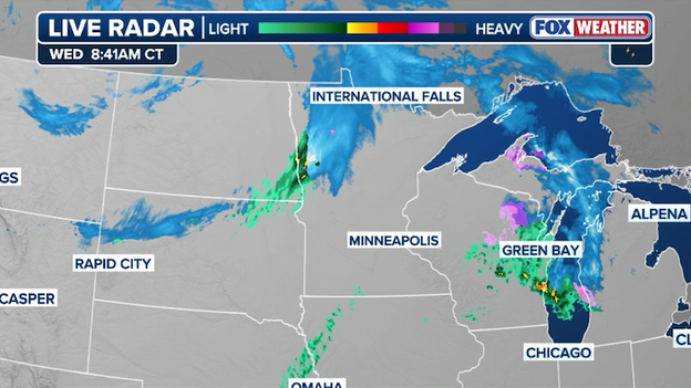
Radar showing a wintry mix and snow moving over portions of the Upper Midwest and Northern Plains.
An area of low pressure spinning over the Upper Midwest is keeping winter in the forecast, with a band of light to moderate snow and mixed precipitation stretching across the Northern Plains.
From eastern Montana into northern Minnesota and the U.P. of Michigan, commuters are dealing with slick spots and reduced visibility as cold Canadian air turns rain into a slushy late-season coating.
While accumulations are generally light, this unseasonable system is a chilly reminder that the spring transition often includes a few more snowflakes before the warmth finally wins out.
Today marks the annual #SafePlaceSelfie day, a national social media campaign led by the National Weather Service and NOAA to promote severe weather preparedness.
The initiative encourages everyone to identify their "safe place" for various weather hazards—whether it's an interior closet for a tornado or higher ground for a flash flood—and share a photo from that location.
By participating, you’re not only checking your own safety plan but also acting as a force multiplier to inspire friends and family to do the same before the next storm hits.
A more traditional severe weather pattern is set to return this weekend, sparking a multi-day threat that stretches from the southern Plains through the Upper Midwest and into the Deep South.
Beginning Saturday and potentially lasting through Tuesday, a series of powerful upper-level disturbances will interact with building moisture and instability, putting all modes of severe weather—including large hail, damaging winds, and tornadoes—on the table.
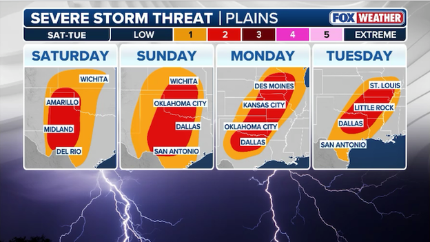
A multi-day severe weather outbreak will threaten millions across the Heartland with tornadoes, damaging winds, and large hail starting Saturrday.
Major metropolitan areas including Dallas, Oklahoma City, Kansas City, and St. Louis are being closely monitored as the threat intensifies on Sunday and Monday. Forecasters warn strong tornadoes and huge hail may hit the region early next week.
While the rounds of heavy rain will provide much-needed drought relief, the FOX Forecast Center warns that localized totals of 2–3 inches could lead to flash flooding across Texas, Oklahoma, and Arkansas.
As an area of low pressure moves across southern Canada, a trailing cold front is set to stall across the Heartland, sparking a multi-day threat of severe weather and heavy rain through Friday.
While the Northern Plains and Rockies contend with damaging wind gusts over 50 mph, moisture surging north will trigger rounds of strong storms and torrential rain farther south across the Central Plains.
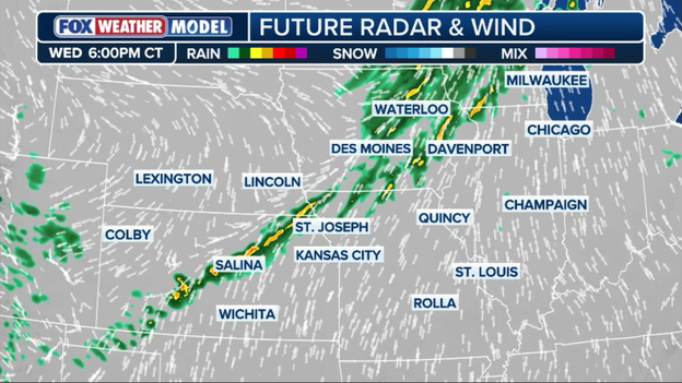
Exclusive FOX Weather Model showing a line of thunderstorms developing across the Heartland on Wednesday evening.
Cities like Wichita, Kansas City, and Des Moines are in the crosshairs for potential flash flooding as localized rain totals could reach 2–3 inches, particularly around the Kansas City metro where a Level 1/4 flash flood risk is in place for Thursday and Friday.
Residents in North Boulder are on high alert this morning as firefighters battle the Goat Trail Fire, which ignited early Wednesday near the mouth of Sunshine Canyon.
The Boulder County Sheriff's Office issued an evacuation warning just before 4:00 a.m. local time for neighborhoods west of the 200 block of Hawthorne Avenue, urging those who need extra time or assistance to leave immediately.
While the fire is currently estimated at roughly 1.7 acres, officials are concerned about fully cured fuels and low humidity levels that have elevated the fire danger across the Front Range this morning.

The Artemis II crew – CSA (Canadian Space Agency) Astronaut Jeremy Hansen (far left) and NASA astronauts Christina Koch (center left), Reid Wiseman (center right), and Victor Glover (right) – pauses to wave after a live conversation with President Donald J. Trump following their historic lunar flyby during Flight Day 6. (Robert Markowitz/NASA-JSC)
On Flight Day 8 of their 10-day mission, the Artemis II crew is shifting their focus from deep-space exploration to the complex logistics of coming home.
After officially exiting the moon's sphere of influence yesterday, Commander Reid Wiseman, Victor Glover, Christina Koch, and Jeremy Hansen are spending today conducting a series of Return Trajectory Correction (RTC) burns to fine-tune Orion's high-speed approach to Earth's atmosphere.
During Tuesday's mission status briefing, NASA officials shared the breathtaking first images captured by the crew during their lunar flyby, offering a new perspective of the lunar far side.
On the recovery front, the agency confirmed that the USS John P. Murtha has officially left port and is steaming toward a midway point in the Pacific Ocean to meet the Orion capsule.
NASA will continue to monitor both the recovery zone weather and the spacecraft's health during daily briefings leading up to Friday’s scheduled splashdown.
As they move closer to Earth, the crew will also begin stowing the cabin—securing equipment and scientific data to ensure everything is locked down for the intense, high-G forces of Friday’s 8:07 p.m. ET splashdown off the coast of San Diego.
While the mainland deals with a spring chill and Heartland storms, Hawaii is bracing for a significant Kona low that is already hammering the islands with torrential rain.
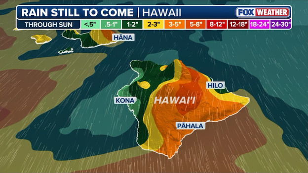
Hawaii is expected to get more than half a foot of rain through Sunday.
A Flash Flood Warning was issued early this morning for parts of the Big Island, where rain rates have reached 1 to 3 inches per hour in areas like Puna and Kaʻū.
With a statewide Flood Watch in effect through Friday, the FOX Forecast Center warns that saturated ground from previous storms will only increase the risk of rapid runoff and landslides as waves of heavy tropical moisture continue to push northward.
The heavy rain threat is shifting its focus to Florida's Atlantic coast today, with a Flood Watch remaining in effect for a massive stretch from Miami to Daytona Beach.
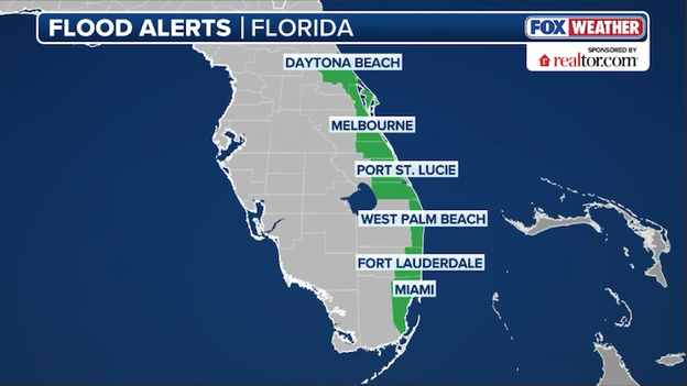
The National Weather Service has issued a Flood Watch for Florida's Atlantic coast through Wednesday.
A stalled front and a deep plume of tropical moisture are expected to trigger slow-moving downpours that could dump another 1–3 inches of rain, with isolated spots seeing even higher totals.
On-shore winds are also picking up, creating hazardous surf conditions and increasing the risk of beach erosion alongside the urban flooding concerns.
South Florida is keeping a close eye on the Atlantic this morning as a cluster of storms and torrential rain churns just offshore from Miami.
While the heaviest downpours are currently remaining over open water, they are close enough to bring increased moisture and gusty conditions to the coastline.
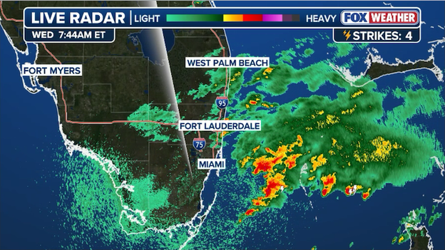
Radar image showing a cluster of heavy rain and thunderstorms just offshore from Miami, Florida this morning.
Farther north, showers are dampening the morning commute from Fort Lauderdale to West Palm Beach, though rain totals there remain significantly lower than the soaking activity seen on radar just to the south.
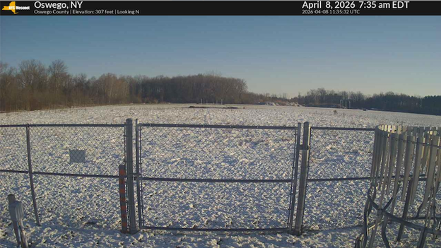
New York State Mesonet camera in Osceola, New York showing snow covering the ground.
The screenshot from the NYS Mesonet camera in Osceola, New York, captures a scene more reminiscent of January than early April.
A fresh blanket of late-season snow covers the ground this morning as a stubborn cold front lingers over the region, dropping temperatures well below the freezing mark.
While spring blooms have already started to emerge in many parts of the state, this unseasonable coating serves as a cold reminder that winter weather can hold a tight grip on Upstate New York well into the spring months.
Spring may be on the calendar, but the Northeast is waking up to a harsh reminder that winter isn't finished quite yet.
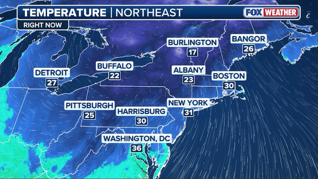
Current temperatures across the Northeast as of 7:30 a.m. ET Wednesday
An unwelcome April chill has sent temperatures plummeting into the 20s and 30s across the region, forcing residents to dig their heavy coats back out of storage.
This unseasonable freeze is especially concerning for local gardeners and farmers, as the sub-freezing air threatens to damage early spring blooms and sensitive budding crops.
Looking for a recap of yesterday’s major weather and space milestones?
We were tracking NASA’s Artemis II crew as they reached a historic peak, traveling farther from Earth than any human in history before beginning their high-speed slingshot back home.
On the weather front, we monitored the late-season snow in the Northeast and persistent flash flooding across the Florida Peninsula.
Click here to read our full archived coverage from Tuesday, April 7, 2026.
You’ve reached the beginning of this live coverage.