Recap: What to expect from 2026 hurricane season before Thursday’s massive CSU outlook drop
Recap: What to expect from 2026 hurricane season before Thursday’s massive CSU outlook drop
Download the AppLIVE coverage continues
View postCoverage for this event has ended.
We have moved our live coverage to a new blog for Thursday, April 9, as we count down to the official 10:00 a.m. ET release of the Colorado State University 2026 hurricane outlook.
Will the burgeoning "Super El Niño" be enough to suppress the season, or will record Atlantic heat take the lead? Join us for real-time analysis, the predictions, and reactions from the National Tropical Weather Conference.
FOLLOW TODAY'S UPDATES: CSU to release 2026 hurricane outlook as Super El Niño threatens to upend the season
The wait is nearly over. On Thursday, the tropical weather community turns its eyes to Colorado State University (CSU) for the release of their highly anticipated 2026 Atlantic Hurricane Season Outlook.
This forecast serves as the industry gold standard, setting the stage for what residents along the Gulf and Atlantic coasts can expect over the coming months.
FOX Weather will be there to bring you every update as it happens.
Starting tomorrow morning, we will launch a brand-new live blog dedicated specifically to the CSU announcement. You can expect real-time data, immediate reaction from our team of experts on the ground at the National Tropical Weather Conference and a deep dive into the numbers that will define the 2026 season.
Whether the forecast leans into the suppressive wind shear of the brewing Super El Niño or the fuel provided by warming ocean temperatures, we’ll break down exactly what it means for you.
The 2026 Atlantic hurricane season is shaping up to be a high-stakes clash of the titans as meteorologists track a burgeoning Super El Niño in the Pacific.
Typically, an El Niño of this magnitude would be a "get out of jail free" card for the Atlantic coast, but 2026 has a wildcard: record-shattering ocean heat.
Here is a breakdown of how this brewing climate giant could dictate the season ahead.
What is a "Super El Niño"?
While a standard El Niño involves a warming of the central and eastern Pacific Ocean, a "Super" event occurs when sea-surface temperatures (SSTs) climb at least 1.5°C to 2.0°C above average.
Current models, including recent guidance from the ECMWF and NOAA, suggest there is a significant chance—some models pointing to a 1-in-3 probability—that this year's warming could reach these historic levels by the peak of the season this fall.
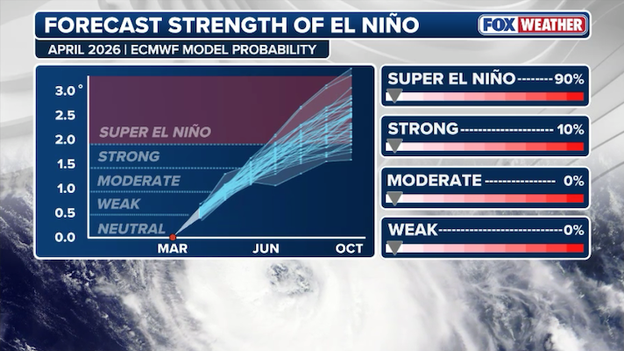
Computer forecast models indicate this year's El Niño could reach "super" status.
The good news: The "shield"
When the Pacific heats up, it triggers a domino effect in the atmosphere. It pumps strong upper-level winds, known as wind shear, across the Atlantic Basin. For a hurricane, wind shear is a death sentence; it effectively tilts the storm's core and prevents it from stacking up and intensifying. Historically, strong El Niño years produce fewer named storms and fewer hurricanes overall.
The catch: Atlantic heat
If this were a normal year, we would expect a very quiet season. However, forecasters are keeping a close eye on the sea-surface temperatures throughout the Atlantic. If those temperatures surge above average, the massive reservoir of heat would provide "rocket fuel" for any storm that manages to find a pocket of calm air.
We saw this exact scenario in 2023, where one of the strongest El Niños on record was canceled out by warm water, resulting in a busy season with 20 named storms.
While hurricanes are officially categorized by their maximum sustained winds, the more immediate threat is often defined by the power of wind gusts.
Experts emphasize these peaks because extreme gusts are almost always responsible for the majority of the most significant structural damage.
In inland areas, it is the instantaneous bursts that topple large trees and disrupt critical power infrastructure.
While most National Hurricane Center products currently highlight sustained winds, internal discussions have been ongoing for years to shift the emphasis toward these higher-impact gusts.
Most experts believe that relying solely on sustained wind speeds can create a false sense of security.
While no changes are immediate for the 2026 hurricane season, extensive work is being done to evaluate how wind gusts serve as a better tool to communicate risk.
During a key session at the National Tropical Weather Conference, the National Hurricane Center threw out a provocative idea for discussion: whether retitling "Potential Tropical Cyclones" to "Potential Tropical Storms" would improve public response.
While the NHC is not currently considering an official name change, the topic was introduced to spark a dialogue among meteorologists and emergency managers about the effectiveness of current risk communication.
The PTC designation is a vital tool that allows for watches and warnings to be issued for disorganized systems before they have a defined center, but the term "cyclone" can be a point of confusion for those who don't associate it with an immediate tropical threat.
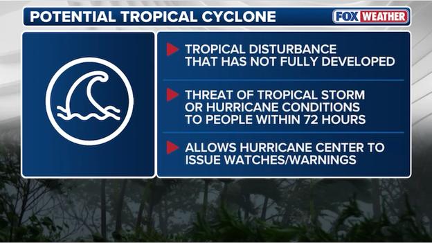
Current criteria for a potential tropical cyclone
By putting this idea on the table, officials are exploring whether a more intuitive title would better translate technical data into actionable risk for the general public.
In scientific terms, "cyclone" is simply the broad label for any rotating system over tropical waters—including depressions, storms, and hurricanes—yet many Americans still find the term abstract.
While the designation remains unchanged for now, the discussion underscores the NHC’s ongoing effort to dismantle misconceptions and ensure that residents understand the danger of a system long before it earns a formal name.
While the peak storm surge graphic provides more of a coastal overview, the potential storm surge flooding map is the NHC’s most detailed tool for individual risk assessment.
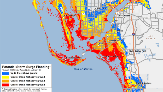
Example of a potential storm surge flooding map
This map shows how far water might push inland, providing a "reasonable worst-case scenario" for specific neighborhoods and streets.
By accounting for variables like the storm's size and landfall angle, it identifies flood risks in areas far removed from the immediate coastline.
A common hurdle is that this map can appear complex because it purposefully depicts a high-end outcome to prevent under-preparation, but it succeeds in answering if your home will be impacted by a specific amount of water.
The National Hurricane Center’s peak storm surge forecast is vital for making life-saving decisions, yet it remains one of the most misunderstood tools in tropical forecasting.
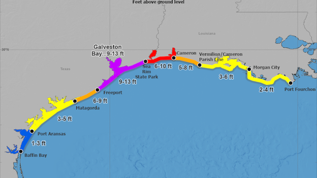
Example of a peak storm surge forecast
This graphic represents the maximum height water could reach above normally dry ground somewhere within a large coastal zone, but it does not mean every inch of that zone will see that peak.
A major shortcoming is that the information focuses primarily on the immediate coastline, often leaving residents with a false sense of security regarding inland surge.
In reality, storm surge is a wall of water that can be pushed miles inland.
Because the peak surge can occur at any point within the colored zones depending on the storm's final angle, relying on a single "dot" on the map is a dangerous strategy.
As we gear up for the start of the 2026 Atlantic hurricane season on June 1, one of the most frequent questions we hear is: "Where do these names come from?"
The 2026 list features 21 names, beginning with Arthur and concluding with Wilfred.
You might recognize some of these; the list is on a six-year rotation, meaning these same names were last used in 2020—a record-breaking season that saw us exhaust the entire list and move into the supplemental alphabet.
The naming process is strictly organized by the World Meteorological Organization (WMO). Here are the ground rules:
- The rotation: There are six permanent lists of names used for Atlantic storms. They rotate every six years, so the 2026 list will appear again in 2032.
- The balance: Lists alternate between male and female names and are arranged alphabetically.
- The exclusions: You won't see names starting with Q, U, X, Y, or Z because there aren't enough easily recognizable names in those letters to maintain a consistent rotation.
- Retirement: If a storm is particularly deadly or costly, its name is retired out of sensitivity and for historical record-keeping. For example, Laura was retired after the 2020 season and has been replaced on this year's list by Leah. Similarly, Molly has joined the rotation starting in 2026, replacing the retired name Melissa.
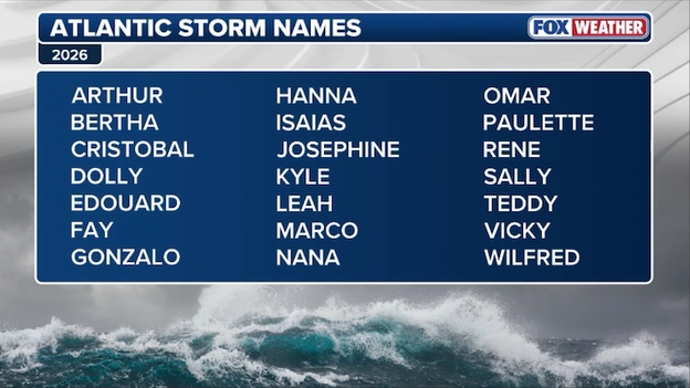
2026 Atlantic tropical storm and hurricane names
What happens if we run out?
In years where more than 21 named storms form, the NHC no longer uses the Greek alphabet (Alpha, Beta, Gamma). Instead, they now use a supplemental list of names approved by the WMO to ensure every storm has a clear, distinct identity.
The National Hurricane Center is stressing that the forecast cone should never be used as the primary tool for deciding when or where to evacuate.
While the cone shows the forecast track of the storm’s center, it tells you nothing about the storm surge or flooding risks that actually trigger evacuation orders.
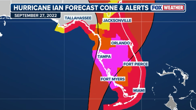
Map showing tropical alerts and the forecast cone for Hurricane Ian (2022). If viewed in isolation, the map implies that residents should evacuate toward Georgia to avoid the path.
If you find yourself in an evacuation zone, it is crucial to remember that not every resident needs to drive hundreds of miles to reach safety.
Effective evacuation is often a matter of traveling tens of miles, not hundreds, to move out of harm's way and into a sturdy, inland structure.
Relying on the cone to time your evacuation is dangerous, as life-threatening hazards frequently do not extend far outside that shaded area.
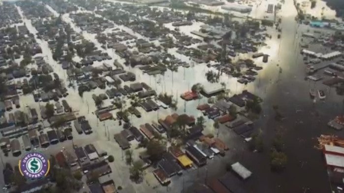
While the forecast cone, wind and storm surge dominate the headlines, the National Hurricane Center is increasingly focused on the silent threat of extreme heat that follows a storm’s passage.
Statistics show that in recent years, more people have died from heat-related causes following landfall than from the storm’s direct impacts.
The tragedy of Hurricane Beryl in 2024 stands as a stark example, where at least 36 people died in the Houston area, with many deaths attributed to heat.
This dangerous trend is primarily driven by widespread power outages, which leave millions of residents without air conditioning during the peak of summer.
By communicating heat risks days before a hurricane arrives, experts aim to shift the public’s preparation mindset beyond the initial impact.
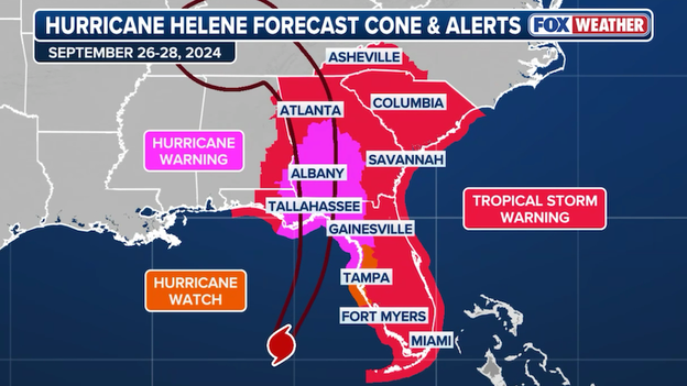
Hurricane Helene forecast cone showing the expansive watches and warnings that extended well outside the forecast cone.
"I’m outside the cone, so I’m safe" is a phrase meteorologists hear every season, but it represents a dangerous breakdown in risk communication.
To combat this, the National Hurricane Center is executing a strategic roadmap designed to localize information and dismantle common misconceptions.
A primary challenge is the public's tendency to over-rely on a single graphic, like the forecast cone, while ignoring broader threats. A major pillar of this evolution involves redesigning graphics to better depict uncertainty, moving away from the idea that a single line defines the danger zone.
While some believe the public can't grasp complex probabilities, the real hurdle is providing accessible tools that translate data into actionable risk. By shifting the focus toward probability-based forecasts, officials hope to ensure that residents take threats outside the cone as seriously as the eye of the storm.
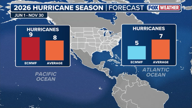
While some early 2026 outlooks are leaning toward an active season, the latest data from the European Centre for Medium-Range Weather Forecasts (ECMWF) offers a notably different perspective for the Atlantic Basin.
According to the model's newest guidance, the Atlantic could see a below-average number of hurricanes this year. The ECMWF is currently projecting 5 hurricanes for the Atlantic season, which falls short of the historical average of 7.
A tale of two oceans
The forecast highlights a significant contrast between the Atlantic and Pacific basins:
- Atlantic Ocean: The model suggests a quieter-than-usual season with only 5 hurricanes anticipated.
- Pacific Ocean: Conversely, the ECMWF is calling for an active season in the Pacific, projecting 9 hurricanes—one above the typical average of 8.
ECMWF data suggests the Atlantic Basin will see fewer hurricanes this season.
Why the divergence?
This conservative Atlantic forecast likely hinges on the development of a strong El Niño. Typically, El Niño conditions increase vertical wind shear across the Atlantic Basin, which acts as a speed bump for developing tropical systems, often tearing them apart before they can reach hurricane strength.
However, meteorologists at the University of Arizona remain cautious. The clash between this suppressive wind shear and the record-warm Atlantic sea surface temperatures remains the biggest variable of the 2026 season.
Whether the shear or the heat wins out will determine if the ECMWF’s quieter forecast holds true.

2026 National Tropical Weather Conference kicks off on South Padre Island, Texas.
National Hurricane Center Deputy Director Jamie Rhome took the stage this morning to kick off the National Tropical Weather Conference, focusing on the critical evolution of tropical forecasting and public safety.
His opening remarks will highlight the NHC's major 2026 initiatives, including the rollout of the newly redesigned forecast cone which now incorporates inland watches and warnings to better communicate total storm risk.
The University of Arizona (UArizona) has released its initial 2026 North Atlantic hurricane season forecast, and the numbers point toward a busier-than-average year.
Despite the potential for a very strong El Niño—a phenomenon that typically suppresses tropical activity in the Atlantic—researchers Kyle Davis and Xubin Zeng are projecting a high level of activity driven by exceptionally warm ocean temperatures.
According to their model, which utilizes a combination of dynamic forecasting and machine learning, they are expecting:
- Named storms: 20
- Hurricanes: 9
- Major hurricanes (Cat 3+): 4
- Accumulated Cyclone Energy (ACE): 155
For context, these figures are significantly higher than the median since 1981, which typically sees 14 named storms and 7 hurricanes.
The big story for 2026 is the clash between two major climate drivers. The University of Arizona model highlights the possibility of the highest sea-surface temperatures (SSTs) ever recorded in the Niño 3.4 region, indicating a powerhouse El Niño.
While El Niño usually creates wind shear that rips storms apart, the researchers note that forecasted Atlantic temperatures are also among the highest in the model's history.
This setup mirrors 2023, where record-breaking Atlantic heat effectively canceled out the suppressive effects of El Niño, leading to an active season.
FOX Weather will continue to track these evolving forecasts. Colorado State University's outlook will be released on Thursday at 10 a.m. ET.

South Padre Island, Texas on Wednesday morning ahead of the National Tropical Weather Conference.
The road to the 2026 Atlantic hurricane season officially runs through South Padre Island this week as the National Tropical Weather Conference (NTWC) kicks off this morning.
Known as the premier gathering for tropical meteorology professionals, the conference brings together the nation's top atmospheric scientists, broadcast meteorologists, and emergency managers to align on the latest forecasting tech and safety messaging.
The halls are filled with a who's who of the weather world, including:
National Hurricane Center (NHC) experts: Forecasters who will be at the helm when the first tropical depression forms.
Renowned researchers: Scientists from institutions like Colorado State University (CSU) who specialize in long-range seasonal outlooks.
Emergency personnel: FEMA and state-level coordinators focused on the last mile of storm protection—getting people out of harm's way.
FOX Weather is your front-row seat to the conference. Throughout the day, we will provide exclusive interviews, one-on-one sit-downs with the experts who write the forecasts, deep dives into the "why" behind the 2026 predictions, and real-time reaction and pre-game analysis as we approach Thursday's massive hurricane season outlook release from Colorado State University.
You’ve reached the beginning of this live coverage.