Live updates: CSU releases 2026 hurricane outlook as Super El Niño threatens to upend the season
Live updates: CSU releases 2026 hurricane outlook as Super El Niño threatens to upend the season
Download the App13 named storms: Colorado State University reveals 2026 Atlantic hurricane outlook
View postCoverage for this event has ended.
While the early headlines for the 2026 hurricane season scream "El Niño" just like they did in 2023, the underlying setup of the Atlantic basin is fundamentally different.
Although 2023 serves as a decent analog year, it clearly defied the odds by producing 20 named storms, which was six above the seasonal average.
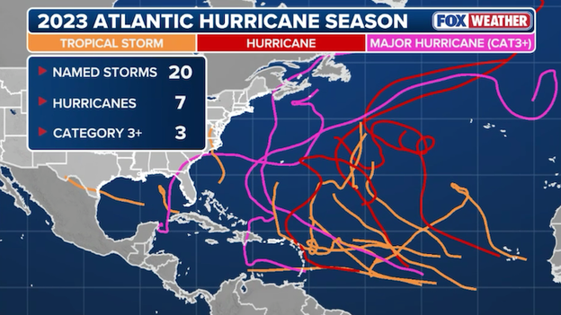
Storm tracks from the 2023 Atlantic hurricane season
In 2026, the environment is trending much more hostile for storm development, suggesting that 2023 may not be the best benchmark for what to expect this year. Breaking down the differences:
Absence of Record Warmth : In 2023, we saw a major clash. While El Niño tried to suppress storms, the Tropical Atlantic was experiencing record-shattering warmth in the Main Development Region. The record heat canceled out the effects of El Niño by providing an excessive amount of fuel.
In contrast, April 2026 is starting with near-normal or even below-average temperatures across the Tropical Atlantic. While the basin will likely warm as summer approaches, it is not starting from the extreme baseline we saw three years ago.
"Super" vs. "Moderate" El Niño: The El Niño of 2023 was strong, but for 2026, models are forecasting an even more robust event. The last super El Niño that corresponded with the Atlantic hurricane season was in 2015, and they do not happen often.
If the forecast verifies, the "cooler" Atlantic waters will not be able to fight back against the El Niño like in 2023.
When we talk about a Super El Niño, we are looking at a phenomenon that historically puts the brake on the Atlantic hurricane season.
The four most recent examples are 1982, 1991, 1997, and 2015. All followed a similar pattern with fewer storms, but often still had a memorable storm.
Here is a breakdown of how the Atlantic responded during these years:
1982: 6 named storms, 2 hurricanes, 1 cat 3+ hurricane
1991: 8 named storms, 4 hurricanes, 2 cat 3+ hurricanes
1997: 7 named storms, 3 hurricanes, 1 cat 3+ hurricane
2015: 11 named storms, 4 hurricanes, 2 cat 3+ hurricanes
Even in these dormant seasons, a storm still found a way to leave their mark more often than not.
Hurricane Bob (1991): A catastrophic outlier, striking New England as a Category 2 and becoming one of the costliest hurricanes in U.S. history at the time.
Hurricane Danny (1997): A slow-moving, lopsided storm that stalled over Alabama and dumped an incredible 36+ inches of rain, causing record-breaking flooding.
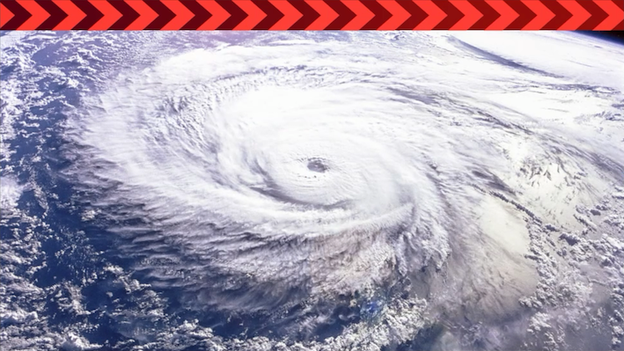
Hurricane Joaquin (2015) : The most notable storm from recent super El Niño years. Joaquin was a powerful Category 4 that devastated the central Bahamas. Moisture from Joaquin went on to fuel an extreme flood event in South Carolina that was responsible for Charleston's worst flooding event on record.
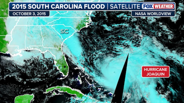
Satellite image showing Hurricane Joaquin east of the Bahamas. Moisture from Joaquin stretches all the way into the East Coast.
Dr. Phil Klotzbach and the team at Colorado State University (CSU) released their initial 2026 Atlantic hurricane outlook earlier today. Their outlook called for a slightly below-average season primarily due to the onset of El Niño.
In the report, CSU provides the probabilities for a major hurricane (category 3+) making landfall along the U.S. coast, which often cause the most damage and life-threatening impacts.
Entire Continental U.S. Coastline
2026 Forecast: 32%
Historical Average: 43%
U.S. East Coast (Including Peninsula Florida)
2026 Forecast: 15%
Historical Average: 21%
Gulf Coast (Florida Panhandle westward to Brownsville)
2026 Forecast: 20%
Historical Average: 27%
Going a step further, it can even be broken down into the likelihood of either a tropical storm, hurricane or major hurricane (category 3+) passing within 50 miles of each coastal state.
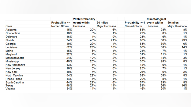
Probability of a tropical storm, hurricane and major hurricane (category 3+) tracking within 50 miles of each coastal state from Texas to Maine. The right-hand table is the historical odds.
While the odds are lower than the historical average, Dr. Klotzbach and other experts are quick to remind us that these lower percentages do not mean zero risk.
Even in a "quiet" year, it only takes one storm to change everything.
Experts have faced a massive "data void" over the open Atlantic. While satellites are great at looking down from space, they struggle to capture exact measurements inside the atmosphere itself. While hurricane hunters provide the most valuable data, it is extremely difficult for planes to conduct missions over the tropical Atlantic.
Enter WindBorne Systems. For the 2026 season, their collection of long-duration Global Sounding Balloons (GSB) is filling this gap. Unlike traditional weather balloons, these can stay aloft for weeks or even months.

Picture of a long-duration Global Sounding Balloons (GSB) from WindBorne
Recent research showed that adding WindBorne data into models led to a statistically significant reduction in hurricane track errors. It has been shown to improve forecasts by as much as 18%.
These balloons do not pop, and provide a continuous stream of data, which can move with a storm across the Atlantic. The critical data from these balloons means we are no longer guessing what is happening in the deep tropics.
NOAA has announced that for the first time this season, data from small unmanned aircraft systems (sUAS) will be directly ingested into the Hurricane Analysis and Forecast System (HAFS).
The HAFS model is NOAA’s high-resolution hurricane model, which is specially designed for forecasting well-defined tropical systems.
This is a massive breakthrough because these small drones can fly in the boundary layer, the turbulent area just above the ocean surface that is far too dangerous for crewed aircraft.
By capturing wind speed, pressure, and moisture at these low levels, drones provide a crucial missing piece when forecasting hurricane intensity.
The integration of this data is likely to improve HAFS intensity forecasts, helping experts better forecast rapid intensification.
The National Hurricane Center is currently tackling a complex storm surge problem: exactly how the wind pushes water toward the shore.
For the 2026 season, a major focus is on reworking how the SLOSH model, the primary tool used to predict storm surge, handles a storm’s wind field.
Historically, the SLOSH model assumed storms were fairly symmetrical, but hurricanes are rarely perfect circles. They often have lopsided shapes where tropical storm force winds reach much further in one direction than another.
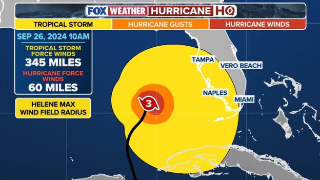
Example of Hurricane Helene (2024) wind field footprint on approach to Florida.
To fix this, the NHC’s Storm Surge Unit is moving toward better resolving the radius of different wind thresholds. This means they are specifically reworking the modeling process to get a more accurate picture of the storm's actual footprint.
While a larger wind field can move a massive volume of water that a smaller, compact storm simply can’t match, size alone doesn't account for the actual shape. Understanding the specific structure of the wind is critical for bays and inlets, like Tampa Bay, where even a slight shift in wind direction can make a huge difference in whether water stays out or floods in.
FOX Weather Hurricane Specialist Bryan Norcross discusses the factors behind Colorado State University's April hurricane season forecast with CSU Senior Research Scientist Dr. Phil Klotzbach from the National Tropical Weather Conference in Texas.
While a strong El Niño is expected for the 2026 season, it will likely not be at full force during the early summer months. This creates a period of high unpredictability for states like Texas and Louisiana.
During these months, we typically lack the African wave train, which is the steady stream of disturbances moving off the African coast. These are the disturbances that fuel major Atlantic hurricanes.
In the interim, the focus shifts entirely to development close to home. Today, water temperatures in Gulf of America are already running above average, providing a source of fuel for any system that manages to spin up.
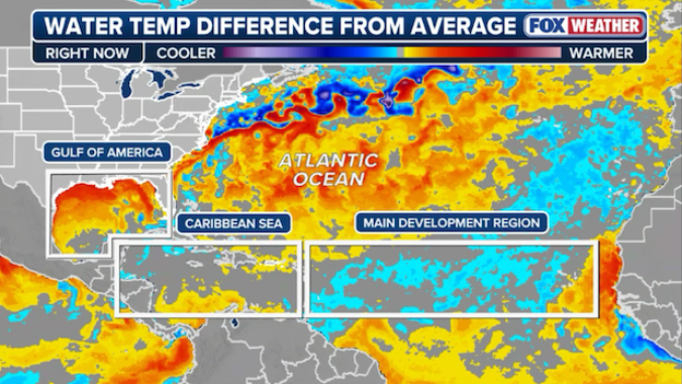
Gulf of America water temperatures are running well above-average close to the coast
Early-season storms are often not strong, but they can become dangerous if conditions align. In an ENSO-neutral state, the hostile upper-level winds are not yet consistent enough to shred developing systems in the Gulf. This lack of wind shear, combined with exceptionally warm local waters, means even a weak disturbance can quickly organize near the shoreline.
Ultimately, while the forecast calls for a quieter peak season, the early summer "neutral" window is a reminder to stay vigilant.
The National Hurricane Center is running a new experimental forecast cone side-by-side with the traditional cone this season to address a long-standing issue.
While the traditional cone is built using uniform circles, this new methodology utilizes ellipses that specifically account for forward speed errors.
By shifting to this method, the NHC is increasing its confidence level for where the center of a storm might track from roughly 67% to 90% probability.
This change means the cone will often appear wider or more "wonky" by day 4 or 5, but it offers a far more honest look at the potential track.
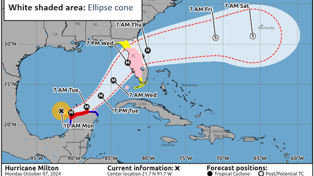
Example of the experimental forecast cone (white) with the current operational forecast cone (re
This approach also allows the NHC to potentially experiment with adding a longer-duration cone beyond day 5. The new methodology keeps the cone at a realistic width, whereas the old forecast cone would have been too wide and unrealistic to provide useful information to the public beyond that window.
None of these changes are operational yet, but it is an exciting time as the NHC pushes forward to improve how we communicate risk.
FOX Weather hurricane specialist Bryan Norcross is on South Padre Island, Texas where Colorado State University's 2026 Atlantic hurricane season outlook was released this morning.
Norcross spoke with meteorologists Stephen Morgan and Marissa Torres on Weather Command to break down the outlook.
While the presence of El Niño is a known Atlantic "hurricane killer," the speed at which it develops is often more important than its final strength.
A slow, creeping onset of El Niño does not provide the same protection for the Atlantic as a sudden, aggressive surge.
For El Niño to suppress hurricanes, it must create strong hostile winds across the Atlantic quickly. In a slow-onset scenario, the atmosphere has time to adjust, and the resulting hostile winds may take time to develop.
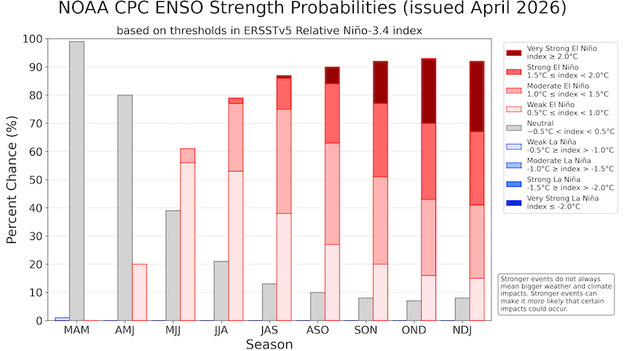
The bars show the chance of El Niño (red bars), ENSO-Neutral (grey bars), and La Niña (blue bars)
Timing is the main piece of the puzzle. If El Niño reaches its peak intensity during August and September, the impact is maximized. Right now there is 90% chance El Niño will develop, but only about a 28% it will be a strong El Niño or even Super El Niño.
If the onset is too slow and does not significantly strengthen until October or November, the peak of the hurricane season may already be over before the atmospheric defense is fully in place.
To understand why the current shift in the Pacific matters so much, we have to look at the historical data.
Dr. Phil Klotzbach of Colorado State University has performed an analysis of Atlantic storms that made landfall over a period of 15 years that correlated with either El Niño or La Niña.
During El Niño years, the Atlantic saw significantly less landfalls. The totals included 37 named storms, 11 hurricanes, and only 3 major hurricanes. In these years, most landfalls occurred along the Gulf Coast.
El Niño creating hostile winds that spread into the Atlantic
This geographical shift makes sense because hostile wind are typically strongest over the open tropical Atlantic during El Niño, preventing storms from forming far out at sea.
In contrast, La Niña years were far more explosive. The data shows 61 named storms, 31 hurricanes, and 10 major hurricanes. Beyond just the higher numbers, there was a much greater distribution of storm locations and where those storms ultimately made landfall.
While Pacific ocean temperatures are grabbing the headlines, the real catalyst for the current climate shift is a change in the wind. As of April 2026, the long-standing La Niña has collapsed due to powerful westerly wind bursts in the tropical Pacific.
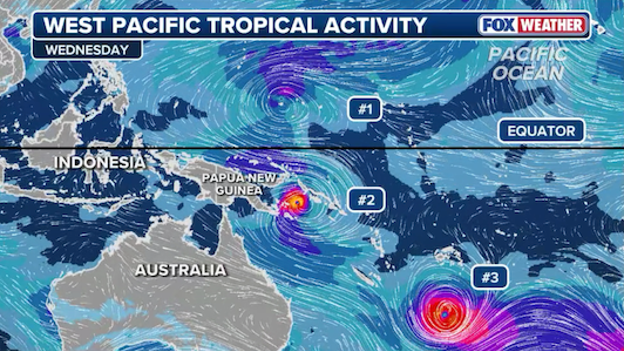
Location of three storms in the West Pacific. Strong winds out the west are occurring between #1 and #2
When these westerly bursts happen, they act as a massive atmospheric shove, sending warm water back toward South America and effectively eroding the cold pool that defined La Niña.
Colorado State University is monitoring these bursts because they are the primary reason for the rapid warming occurring right now.
For the Atlantic, this shift is a critical development for the 2026 season. While the warming water is the result, it is the westerly wind bursts doing the heavy lifting to reshape our global weather pattern.
The Atlantic hurricane season officially begins on June 1 and concludes on November 30. This six-month window is designated because it coincides with the period when atmospheric and oceanic conditions are most conducive to tropical development.
The timing is primarily driven by sea surface temperatures; for a hurricane to form and sustain itself, ocean waters typically need to be at least 80°F (26.5°C). While the season peaks in September when ocean heat is at its maximum, storms can occur outside these dates if the environment—including low wind shear and high moisture—aligns correctly.
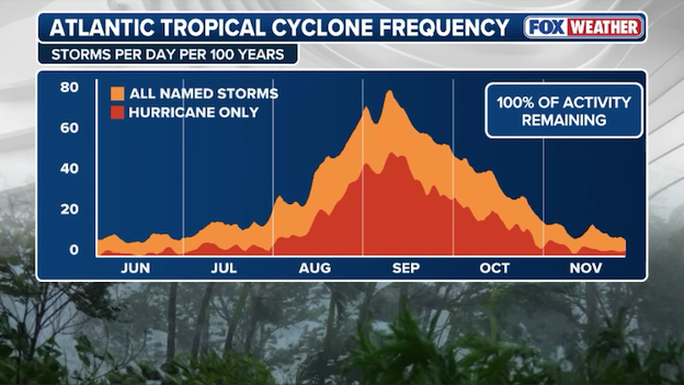
Atlantic hurricane season frequency chart showing when the most storms and hurricanes typically occur
Following the Colorado State University outlook, all eyes will soon shift to NOAA (the National Oceanic and Atmospheric Administration), which is expected to release its official 2026 Atlantic hurricane season outlook in late May.
While CSU’s early April forecast is the "gold standard" for early season predictions, NOAA’s outlook offers a more refined view as atmospheric conditions like the brewing El Niño become clearer.
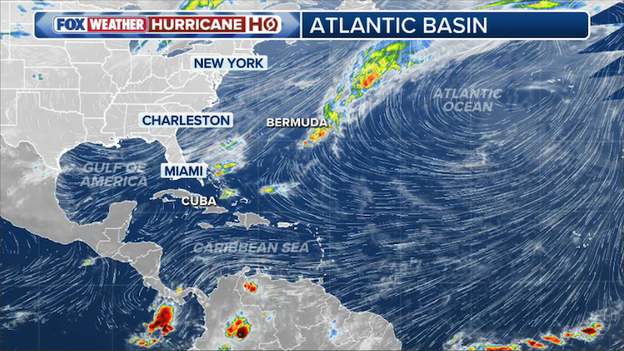
Satellite overview of the Atlantic Basin on Thursday, April 9, showing no active tropical storm activity.
The National Hurricane Center will also ramp up its routine operations ahead of the June 1 season start, beginning its daily issuance of regular Tropical Weather Outlooks on May 15, 2026.
For the 2026 season, NOAA is introducing significant enhancements to its communication tools, most notably an experimental forecast cone that for the first time will highlight inland watches and warnings to better communicate wind risks away from the immediate coastline.
The Colorado State University team issues extended-range forecasts to provide information that is superior to simple climatology, helping to satisfy public curiosity and bring attention to the hurricane problem.
While it is impossible to precisely predict storm activity as early as April, these outlooks identify how global ocean and atmosphere features are arranged to determine the probability of an active or inactive season.
The research team believes it is important to share these odds because the Atlantic basin exhibits the largest year-to-year variability of any global tropical cyclone basin.
Even with a forecast calling for "somewhat below-normal" activity, meteorologists at Colorado State University and at FOX Weather have a singular, vital message for the public: It only takes one.
Historical data and seasonal storm counts are valuable for understanding atmospheric trends, but they do not predict exactly where a storm will strike or how much damage it will cause to a specific community.
A quieter season on paper does not translate to a lower risk for an individual homeowner. The CSU team reminds coastal residents that even in inactive years, a single landfalling hurricane can result in a devastating and life-changing season for those in its path.
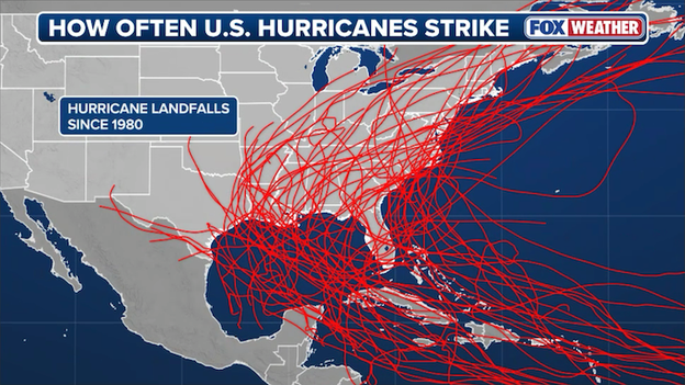
Map showing all hurricane landfalls in the United States since 1980.
Because the probability of a landfall at any one specific location is statistically low every year, it can be easy to fall into a false sense of security during "below-average" years.
However, the 2026 outlook makes it clear that thorough preparations should be a seasonal staple, regardless of whether experts predict 6 hurricanes or 16.
As the CSU report notes, "coastal residents are reminded that it only takes one hurricane making landfall to make it an active season for them".
The 2026 forecast marks a significant shift in expectations, as it is the first time since 2019 that Colorado State University has issued a "below-average" activity prediction in its initial April outlook.
In the years following 2019, the Atlantic basin was dominated by a rare "triple-dip" La Niña and record-breaking ocean warmth, leading to a string of highly active seasons.
This return to a below-normal forecast reflects the team's high confidence in the suppressive power of the burgeoning 2026 El Niño.
While record-breaking Atlantic warmth has been a major headline in recent months, the Colorado State University (CSU) team identifies a powerful atmospheric shift as the primary driver for the 2026 season.
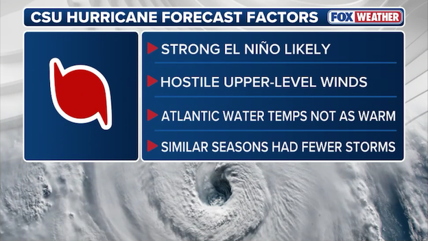
Factors used in Colorado State University's 2026 Atlantic hurricane season outlook.
Here are the critical factors Dr. Phil Klotzbach and his team analyzed to reach their "somewhat below-normal" prediction:
The dominance of El Niño: Forecasters anticipate that current weak La Niña conditions will transition rapidly to a moderate or strong El Niño by the peak of the season. This is the most significant factor in the 2026 outlook, as El Niño typically increases vertical wind shear across the Atlantic, which can tear storms apart before they organize.
Competing Atlantic temperatures: The forecast is a tug-of-war between ocean and atmosphere; while sea surface temperatures in the western tropical Atlantic are warmer than normal—providing potential fuel for storms—the eastern and central Atlantic are actually slightly cooler than average.
Extreme vertical wind shear: Due to the burgeoning El Niño, the ECMWF ensemble model is predicting extremely high levels of vertical wind shear across the Main Development Region (MDR). In fact, these shear levels are forecast to be the second-highest recorded since 1981, trailing only the 2015 season.
Historical analog years: The team looked at past seasons that shared similar climate setups to 2026, specifically identifying 2006, 2009, 2015, and 2023 as the best comparisons for what this year might hold.
New AI guidance: For the first time, CSU utilized the Ai2 Climate Emulator (ACE2), a machine learning-based model. This AI guidance aligned with traditional models, pointing toward a season hindered by strong upper-level westerly winds across the tropical Atlantic.
Despite these suppressive factors, CSU reminds residents that the probability of a major hurricane tracking through the Caribbean still remains at 35%, and the probability of a major hurricane hitting the entire continental U.S. coastline is 32%.
FOX Weather meteorologists remind everyone "it only takes one"—a single landfalling hurricane can be devastating and make the season an active one. Hurricane preparations should be made for every season, regardless of what seasonal outlooks say.
Colorado State University’s 2026 outlook is produced using a diverse suite of five primary components, including a statistical regression model, a combined statistical/dynamical model, and a selection of analog seasons.
For the first time this year, the team has also incorporated a machine learning-based climate model known as the Ai2 Climate Emulator (ACE2) to serve as additional guidance.
These methods are heavily rooted in nearly 40 years of historical data to ensure that the predictors used—such as sea surface temperatures and zonal winds—demonstrate significant hindcast skill.
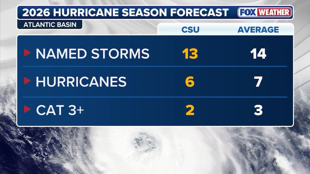
Colorado State University has released its highly anticipated 2026 Atlantic hurricane season outlook, predicting a somewhat below-normal level of activity.
Lead researcher Dr. Phil Klotzbach and his team are calling for 13 named storms, 6 hurricanes, and 2 major hurricanes.
Colorado State University's 2026 Atlantic hurricane season outlook
The primary driver behind this quieter forecast is the expected transition from weak La Niña conditions to a moderate or strong El Niño during the peak of the season.
Forecasters anticipate that this robust El Niño will dominate the tropical circulation, creating high levels of vertical wind shear that typically act to suppress storm development across the Atlantic basin.
Despite the lower predicted numbers, experts emphasize that coastal residents should remain prepared, as it only takes one landfalling storm to make for an active season.
When hurricane experts talk about what is driving global tropical activity, they are usually referring to a specific patch of water in the central Pacific Ocean known as the Nino 3.4 region.
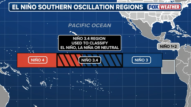
Location of the El Niño-Southern Oscillation (ENSO) regions
The National Hurricane Center (NHC) and other major agencies monitor the Nino 3.4 region because it is the primary indicator for the El Niño-Southern Oscillation (ENSO).
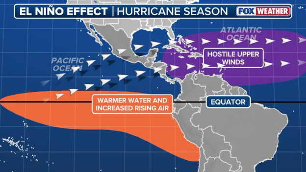
When water temperatures in this box are at least 0.5°C above average, we enter an El Niño phase. For the Atlantic, this usually means a quieter season. Warm water in the Pacific shifts the jet stream, creating hostile winds that shreds developing tropical systems before they can organize.
Because the Nino 3.4 region sits at the intersection of major atmospheric currents, it acts as a global thermostat. Even a tiny shift in temperature within this specific region can trigger a domino effect that alters rainfall, temperature, and storm tracks.
It is official: La Niña has left the building. In its latest monthly update issued today, NOAA’s Climate Prediction Center (CPC) issued its Final La Niña Advisory, declaring that the pattern has officially dissipated.
For the first time in months, the tropical Pacific has transitioned to ENSO-neutral conditions, which are favored to remain in place through the early summer.

ENSO-neutral conditions emerged, as indicated by near-average sea surface temperatures (SSTs) in the central and east-central equatorial Pacific Ocean
However, this "neutral" phase appears to be a brief pit stop. NOAA has simultaneously issued an El Niño Watch, noting a 61% chance that El Niño will emerge as early as the May-July period and persist through the end of the year.
Key takeaways from the April update:
Neutral is here: Sea surface temperatures in the central and east-central equatorial Pacific have returned to near-average levels.
The Heat is rising: Subsurface ocean temperatures have increased for five consecutive months, providing the necessary fuel for an upcoming El Niño.
The El Niño threat: While a transition is likely, there is a wide range of possibilities for its strength—including a 1-in-4 chance of a "very strong" El Niño by next winter.
This transition is a major piece of the puzzle for the 2026 hurricane season, as the shift from La Niña to El Niño typically brings increased wind shear that can help suppress tropical development in the Atlantic.
If you’ve noticed that early hurricane outlooks often come with a heavy dose of caution, it isn't just meteorologists being non-committal. It is actually due to a phenomenon known as the "Spring Predictability Barrier."
This "barrier" refers to a specific window between March and May when global climate models struggle to predict the future state of the El Niño-Southern Oscillation (ENSO).
Because the transition between El Niño and La Niña typically happens during the northern hemisphere spring, the ocean and atmosphere are in a state of flux, making long-range data more unreliable.
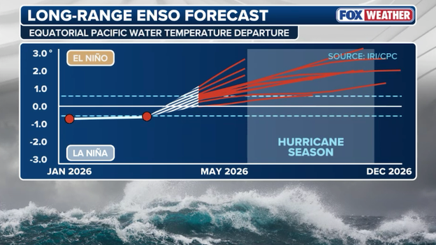
Current long-range El Niño-Southern Oscillation (ENSO) forecast
This barrier plays havoc on hurricane forecasting; a late-developing El Niño can sheer storms apart, while a La Niña can charge the season.
Once we move into June and July, ocean temperatures in the Pacific stabilize and provide forecasters with the clarity needed to issue more confident forecasts.
Current data for the 2026 season is very bullish on El Niño conditions, but until we clear this spring window, those predictions may change.
The Colorado State University (CSU) seasonal hurricane forecast is currently in its 43rd year, standing as one of the most respected institutions in tropical meteorology.
The project was pioneered by the late Dr. William Gray, who served as the lead author for over two decades and remained a co-author until his passing in 2016.
Dr. Gray was a visionary in the field, conducting groundbreaking research on hurricane structure, genesis, and cumulus convection that laid the foundation for modern seasonal prediction.
Today, the research legacy continues under the leadership of Dr. Philip J. Klotzbach and a dedicated team of scientists who continue to refine the models Gray first developed.
The project has benefited immensely from former project members such as Chris Landsea, John Knaff, and Eric Blake, as well as ongoing support from various insurance and meteorological sponsors.
As we wait for Colorado State University's numbers to drop at 10:00 a.m. ET, the question on everyone’s mind at the National Tropical Weather Conference is: Which climate giant will win the tug-of-war in 2026?
Predicting a hurricane season months in advance is a complex puzzle. Here is a breakdown of the primary ingredients Dr. Phil Klotzbach and the CSU team are likely weighing in today’s outlook.
The 'Super El Niño' wildcard
The biggest story of the 2026 season is the rapid transition in the Pacific. La Niña is waning rapidly, and a powerful "Super El Niño" is currently brewing.
- The effect: El Niño typically acts as a hurricane killer for the Atlantic. It creates strong vertical wind shear—fast-moving winds in the upper atmosphere that can tilt or shred a developing tropical system before it can organize.
- The uncertainty: The timing is everything. If El Niño reaches "Super" status by August, it could create an invisible shield over the Caribbean and Gulf of Mexico.
Atlantic 'rocket fuel' (ocean temperatures)
Counteracting wind shear is the literal heat under our feet. Sea surface temperatures (SSTs) in the Gulf of Mexico are hovering above average right now.
- The effect: Warm water is the fuel for hurricanes. Even in high-shear years, exceptionally warm oceans can allow storms to overcome atmospheric obstacles and undergo rapid intensification.
- The conflict: CSU must decide if the suppressive winds of El Niño are strong enough to cancel out the explosive potential of these warm waters.
The West African Monsoon & Saharan dust
We also look to the east. The strength of the African Easterly Waves—the seeds of about 85% of major hurricanes—depends on the West African Monsoon.
A wetter-than-normal season in the Sahel region of Africa typically leads to more robust tropical waves, while early season Saharan Dust plumes can choke out storms by importing dry, stable air into the tropics. Forecasters are watching to see if a dominant high-pressure system will keep the Atlantic dusty through July.
Historical analogs
Forecasters don't just look at models; they look at history. The CSU team selects analog years—past seasons that featured similar setups (like a burgeoning El Niño following a multi-year La Niña).
Years to watch: Watch for Dr. Klotzbach to mention years like 1997 or 2015. These were years where powerful El Niños significantly suppressed storm counts, though they still produced notable impacts.
Today’s forecast isn't just a single number; it’s a probability. Whether CSU leans toward an "average" (14 named storms) or "below average" (11–12 named storms) season will largely depend on how much credit they give to El Niño’s ability to fight off the Atlantic’s warmth.
As we count down to the official start of the season on June 1, it’s time to familiarize ourselves with the 21 names that could soon be scrolling across the FOX Weather App. The 2026 Atlantic list begins with Arthur and ends with Wilfred.
If some of these names look familiar, it’s because they are! The World Meteorological Organization (WMO) maintains six rotating lists of names for the Atlantic basin. This means the 2026 list was last used in 2020 and will be used again in 2032.
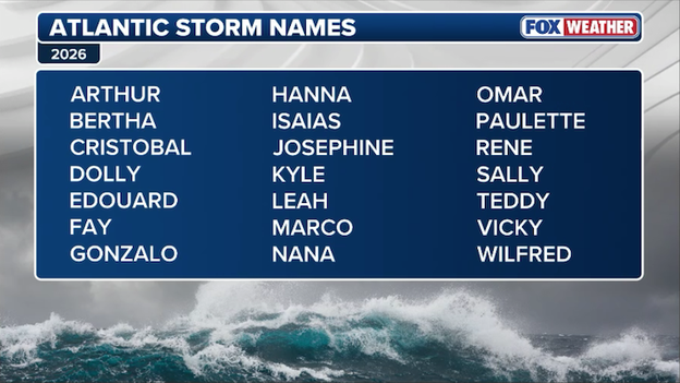
2026 Atlantic tropical storm and hurricane names
How the naming process works:
Why we name them: Names are used instead of coordinates or numbers because they are much easier for the public and emergency responders to remember and communicate during a crisis.
The criteria: To make the list, names must be short, easy to pronounce, and reflect the different cultures and languages (English, Spanish, and French) found around the Atlantic and Caribbean.
The "Skipped" letters: You won’t see a Hurricane "Quentin" or "Zachary." The letters Q, U, X, Y, and Z are skipped because there simply aren't enough easily recognizable names starting with those letters to sustain a six-year rotation.
Retirement: A name is only removed from the rotation if a storm is so deadly or costly that future use would be insensitive. For example, the name Melissa was recently retired following the 2025 season and has been replaced by Molly for future rotations.
What happens if we run out?
In the rare event that we have more than 21 named storms, we no longer use the Greek Alphabet (Alpha, Beta, etc.). Instead, the National Hurricane Center will pull from a supplemental list of names approved by the WMO.
Colorado State University (CSU) will release its first outlook for the 2026 Atlantic hurricane season at 10 a.m. ET.
The tropical weather community has officially converged on South Padre Island, Texas, for the National Tropical Weather Conference, and all eyes are on the clock.
Colorado State University (CSU) will release its first formal outlook for the 2026 Atlantic hurricane season at 10 a.m. ET—a forecast that serves as the definitive roadmap for the months ahead.
This year’s outlook is particularly high-stakes as experts weigh a brewing Super El Niño—which typically acts as a shield against Atlantic storms—against warming ocean temperatures that could provide rocket fuel for any system that develops.
FOX Weather is live on the ground with complete coverage throughout the day. Following the release, FOX Weather Hurricane Specialist Bryan Norcross will provide exclusive analysis, breaking down what the projected storm counts actually mean for your backyard.
Norcross will also sit down with Dr. Phil Klotzbach, the lead author of the CSU outlook, to discuss the specific atmospheric drivers—from the Saharan Air Layer to the looming Pacific warming—that are expected to define the 2026 season.
Don't miss a beat: Stick with our live blog for the official numbers, the full list of 2026 storm names, and immediate reaction from America’s Weather Team.
While we wait for the official Colorado State University numbers to drop, you can catch up on all the action from the opening day of the National Tropical Weather Conference.
Our team spent Wednesday on the ground in South Padre Island, Texas, chatting with the world's leading hurricane experts about the volatile setup for the 2026 season. From the rapid intensification of the brewing "Super El Niño" to the debut of the National Hurricane Center’s redesigned forecast cone, yesterday’s sessions laid the groundwork for today’s big reveal.
Click here for a full recap of Day 1 at the National Tropical Weather Conference.
You’ve reached the beginning of this live coverage.