What a strong El Nino means for ski season
NOAA forecasters anticipate the El Niño weather regime will continue through at least the spring, with a 62% chance of its presence during April-June 2024.
Odds of historic El Nino increase for this winter
NOAA's latest outlook on El Nino now gives a 35% chance of a "historic level" El Nino with high odds some form of El Nino sticks around through the spring.
A year after a historic winter snowfall season across the West, skiers and snowboarders are gearing up for another year with a weather regime that snow enthusiasts aren’t accustomed to – El Niño.
Much like La Niña, El Niño is just a stage of the El Niño-Southern Oscillation (ENSO), which is determined by water temperature anomalies in the eastern and central Pacific.
As of its latest outlook, NOAA reported the average water temperature anomaly in the Pacific was between 1-2 °C, meaning a significant event was underway.
During an El Niño cycle, the southern jet stream is usually more active than normal, which can help produce more precipitation but lead to warmer temperatures.
"The reason that’s important is those sea-surface temperatures control where normally large thunderstorms are, what we would call deep convection is," Dave DeWitt, the director of NOAA’s Climate Prediction Center, told FOX Weather. "And that deep convection actually has a large influence on the jet stream. And when you have an El Niño event, the jet stream tends to shift south and east of its normal pattern. And that’s how it has major impacts over the U.S."
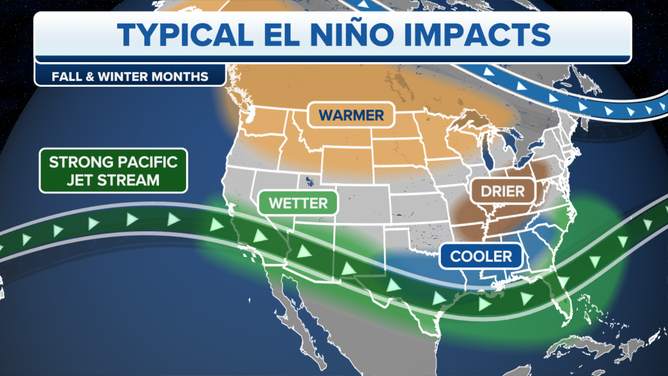
Typical El Nino impacts become more likely with a strong or historic event.
(FOX Weather)
The results can mean a mixed bag for ski resorts around the country. While sports enthusiasts welcome an increase in precipitation, a warmer flow can be a detriment for some resorts.
If climatology places out, communities in the Southwest stand to benefit the most from the increased precipitation. Resorts that usually miss out on seeing additive effects include the Northwest and Northeast.
Every El Niño event is different and is subject to water temperature anomalies and jet stream patterns.
A rare triple-dip La Niña produced historic snowfalls across the West during the 2022-23 winter season - an outcome that was largely unexpected despite forecasters' best attempts to produce accurate outlooks.
EL NINO’S ODDS FOR ‘HISTORICALLY STRONG’ EVENT INCREASE, COULD LINGER THROUGH THE SPRING
Another caveat forecasters are now forced to keep an eye on are changing weather patterns associated with climate change.
NOAA reports there has been a steady decrease in snow coverage across the Lower 48, leading to many wondering what happened to the old-fashioned winter wonderlands.
"Unsurprisingly, because of climate change, over most of the contiguous United States we have trended toward less snowy winters. This doesn’t mean that it never snows, or we cannot get big snowstorms, but that snowfall has gradually trended downward over time," the authors of an ENSO blog recently stated.
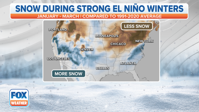
Snowfall during strong El Nino winters
(FOX Weather)