How forecasters use the Winter Storm Severity Index to warn of hazardous weather
The index takes into consideration meteorological and non-weather data to depict how significant impacts can be
Learn about the Winter Storm Severity Index
The index can convey the impacts of winter weather
Even though the calendar doesn’t show the lower 48 being in the heart of winter, the National Oceanic and Atmospheric Administration’s Weather Prediction Center is working around the clock to update the agency’s Winter Storm Severity Index, to warn of impacts from approaching storm systems.
The WSSI is a recently developed tool meant to aid in decision-making for when snow, ice, wind and freezing temperatures could be disruptive.
The approach is similar to the Storm Prediction Center’s categorical outlook for thunderstorms, but instead of warning about hail, wind and tornadoes, the WPC product warns of impacts from winter weather.
DON’T LEAVE ANY OF THESE ITEMS IN YOUR CAR THIS WINTER
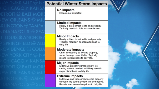
The Winter Storm Severity Index ranges from none to extreme.
(FOX Weather)
The index takes into account non-meteorological data such as population, land use and vegetation to determine an expected system’s severity.
A region that is home to more people or has vulnerable vegetation would likely rank higher on the WSSI because of the potential for more significant impacts.
The scale ranges from none to extreme, and impacts can start to be felt when an area is highlighted in yellow. Limited impacts include small accumulations of snow and ice, but in large part, society can go about its normal routine.
More significant impacts begin to be felt when an area is placed under a moderate or orange zone. This designation equates to an ice or snow event that may take a day or two to recover from.
In the rarest of events, forecasters may put communities under an extreme impact level. This would equate to a historic snowstorm or blizzard. Recovery in terms of clearing roads and restoring utilities may take several days to more than a week.

Example of a display of the WSSI from a 2019 snowstorm.
(NOAA)
The National Weather Service warns the scale is not meant to be the sole source of information about a winter storm’s effects but could be used to provide clarity on expected impacts.
WHEN CAN YOU EXPECT THE FIRST SNOW OF THE SEASON?
With the experimental product, impact outlooks only go out 72 hours but can be broken down into snow amount, snow load, blowing snow, ground blizzard, ice accumulation and flash freeze events.
Each component has a similar goal as the main overall outlook, to show where winter weather could be disruptive to travel, utilities and other vital functions of everyday life.
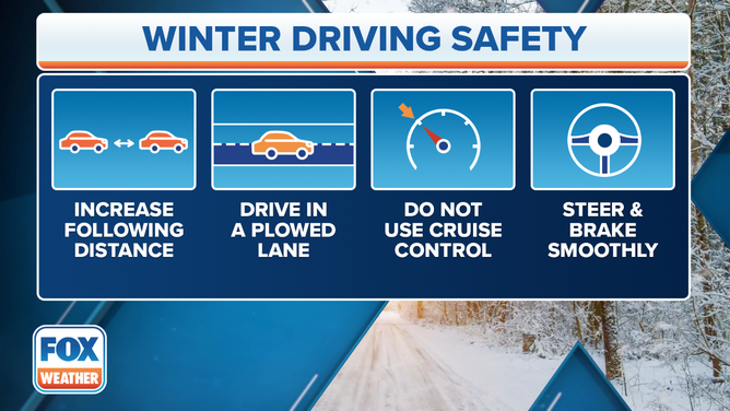
Winter Driving Safety
(FOX Weather)