How the weather you’re accustomed to affects National Weather Service Heat Warnings, Advisories
Locations farther north have lower thresholds for heat alerts since people are less accustomed to hot weather
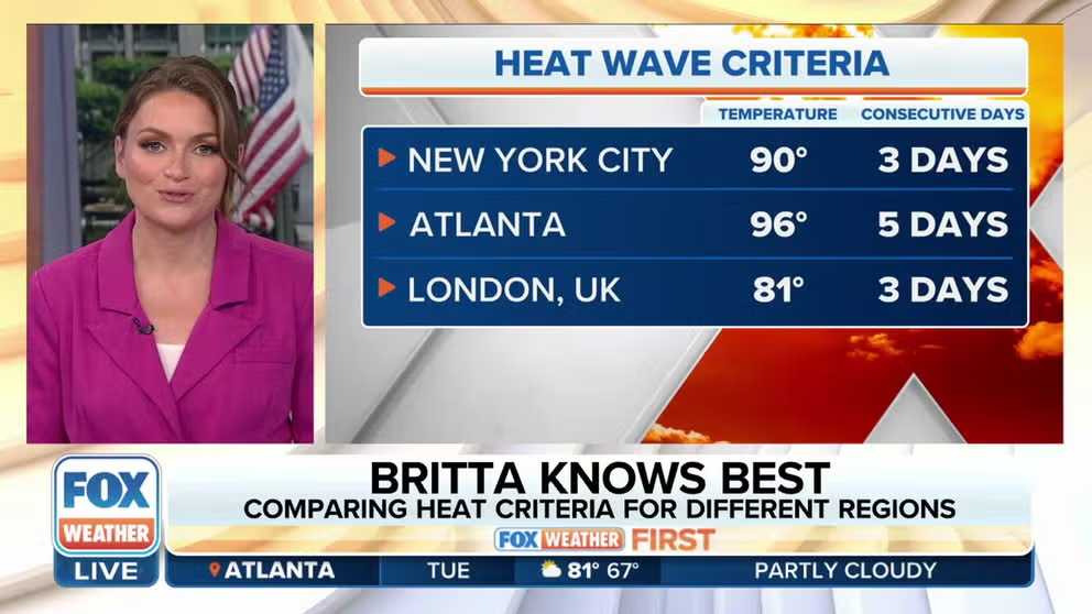
Comparing heat wave criteria for different regions
The criteria for a heat wave varies by region. FOX Weather meteorologist Britta Merwin explains why there are regional differences.
When the combination of heat and humidity is expected to result in dangerous conditions that can cause heat-related illnesses, the National Weather Service issues a variety of alerts to help people stay safe in the hot weather.
The thresholds that trigger Excessive Heat Watches, Excessive Heat Warnings and Heat Advisories are not clear-cut, however.
Since every region of the United States experiences a different climate, people become accustomed to the climate of the region in which they live. That means what is hot to a longtime resident of Maine might not be hot to someone who has spent many years in Florida.
In general, locations farther north don’t have to be as hot for heat alerts to be issued by the NWS because extreme heat is less frequent there. Areas farther south are more accustomed to hot, humid weather, so a higher threshold must be met before watches, warnings or advisories are posted. If this wasn’t the case, parts of the South would be under a Heat Advisory nearly every day in the summer.
HOW TO WATCH FOX WEATHER ON TV
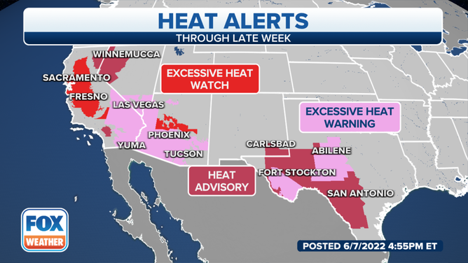
NOT A CURRENT MAP – An example of the various heat alerts issued across the West and the southern Plains on Tuesday, June 7, 2022.
(FOX Weather)
For example, a Heat Advisory – the least extreme type of heat alert – won’t be issued in the Sunshine State until the heat index is predicted to reach at least 108 degrees for two or more consecutive hours. But in Maine, a forecast heat index of 95 degrees or higher for at least two consecutive hours would trigger the NWS to issue a Heat Advisory there.
Excessive Heat Warnings – the most extreme type of heat alert – have a higher threshold than Heat Advisories. Using the same example from above, an Excessive Heat Warning would be issued in Florida if the heat index is expected to reach at least 113 degrees for two or more consecutive days. Residents of Maine can expect the NWS to hoist Excessive Heat Warnings when heat indices are forecast to reach or exceed 105 degrees for at least two consecutive days.
If the NWS has moderate to high confidence (50 to 79%) that an Excessive Heat Warning will be needed in the upcoming days, it can issue an Excessive Heat Watch 24 to 72 hours in advance of the required heat index thresholds being met. Then, if the forecast remains on track and confidence increases to 80% or greater, the Excessive Heat Watch will be upgraded to an Excessive Heat Warning 12 to 36 hours in advance.
Heat Advisories are also issued 12 to 36 hours in advance if the NWS has 80% or greater confidence of advisory-level heat index criteria being met. Additionally, it can choose to convert an Excessive Heat Watch to a Heat Advisory (instead of a warning) if the forecaster’s confidence decreases and warning-level thresholds are no longer expected to be achieved.
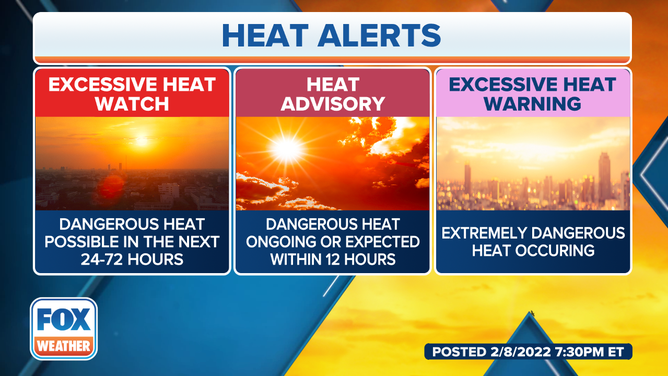
These are the three types of heat alerts issued by the National Weather Service.
(FOX Weather)
Eastern US
The map below shows the criteria that must be met for a Heat Advisory to be issued in the eastern U.S. Areas in the mid-Atlantic and Southeast have the highest thresholds, while the lowest thresholds are from upstate New York into northern New England.
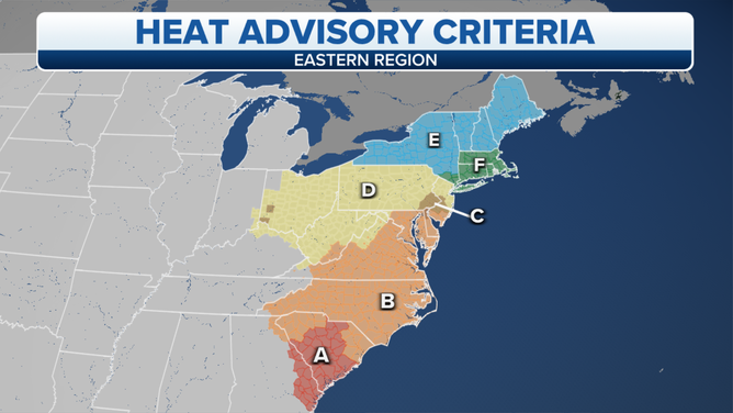
Heat Advisory criteria in the eastern U.S. A = 110 degrees or more. B = 105 degrees or more. C = Kalkstein procedures. D = 100 degrees or more. E = 95 degrees or more. F = 95-99 degrees for 2 consecutive days or 100-104 degrees for any duration.
(FOX Weather)
The next map shows the thresholds that must be achieved for the NWS to issue an Excessive Heat Warning. Again, the hottest conditions are required in the mid-Atlantic and Southeast, while areas from the upper Ohio Valley to New England have slightly lower requirements to warrant a warning.
WHAT IS THE HEAT INDEX AND WHY IS IT IMPORTANT TO YOUR HEALTH?
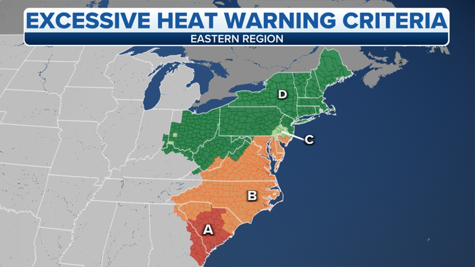
Excessive Heat Warning criteria in the eastern U.S. A = 115 degrees or more. B = 110 degrees or more. C = Kalkstein procedures. D = 105 degrees or more.
(FOX Weather)
The Philadelphia, Cincinnati and Dayton, Ohio, metro areas use the "Kalkstein procedures," a methodology developed by Dr. Larry Kalkstein of the University of Delaware that takes into account the time of year and urban vs. rural areas.
For example, early-season heat waves can have a greater impact on human health because people haven’t yet adapted to the hot weather.
Most people would likely agree that a 90-degree day in April or May feels much hotter than a 90-degree day in August or September because, in the spring, you haven’t been exposed to such high temperatures in over six months. By late summer and early fall, you’re used to those conditions because you’ve experienced them for the last few months.
WHY 50 DEGREES FEELS FRIGID TO SOME BUT WARM TO OTHERS: THE SCIENCE OF ACCLIMATION
The Kalkstein procedures also factor in the enhanced harmful effects of heat waves in urban areas, where there is widespread blacktop and a higher population density than in the more rural communities away from the cities. Blacktop absorbs heat from the sun, which is why cities tend to be hotter than the surrounding suburbs that have more grassy areas. Additionally, with a greater number of people living in cities, there is a larger population subjected to the dangerous heat.
Therefore, the Philadelphia, Cincinnati and Dayton urban corridors have lower thresholds for heat alerts earlier in the season than later in the season, as well as lower thresholds than some of the outlying areas due to the urban influence.
Below is an example used by the NWS office in Philadelphia/Mount Holly, New Jersey, for the issuance of Heat Advisories.
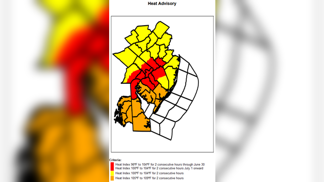
Heat Advisory criteria used by the National Weather Service office in Philadelphia/Mount Holly, New Jersey.
(National Weather Service)
As you can see, the criteria for the Philadelphia urban corridor are different before June 30 than the criteria from July 1 onward.
Southern US
The map below shows the criteria that must be met for Heat Advisories to be issued in the southern U.S.
Areas along the Gulf Coast and parts of Texas and Oklahoma have the highest criteria to warrant a Heat Advisory. Portions of the Texas and Oklahoma panhandles westward into New Mexico have the lowest thresholds for NWS Heat Advisories, especially over the higher elevations.
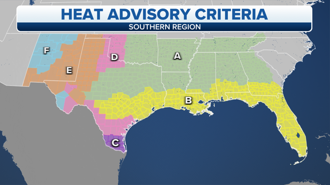
Heat Advisory criteria in the southern U.S. A = temperature of 103 degrees or heat index of 105 degrees. B = temperature of 103 degrees or heat index of 108 degrees. C = temperature or heat index of 111 degrees. D = temperature or heat index of 110 degrees. E = temperature or heat index of 105 degrees. F = temperature or heat index of 100 degrees.
(FOX Weather)
This also holds true for Excessive Heat Warnings. The Gulf Coast and portions of Texas and Oklahoma have the highest thresholds to meet, while the NWS uses lower criteria for the areas that aren’t typically as hot from parts of the Texas and Oklahoma panhandles westward into New Mexico.
WHY DEW POINT IS THE BEST WAY TO CLASSIFY HOW MUCH HUMIDITY IS IN THE AIR
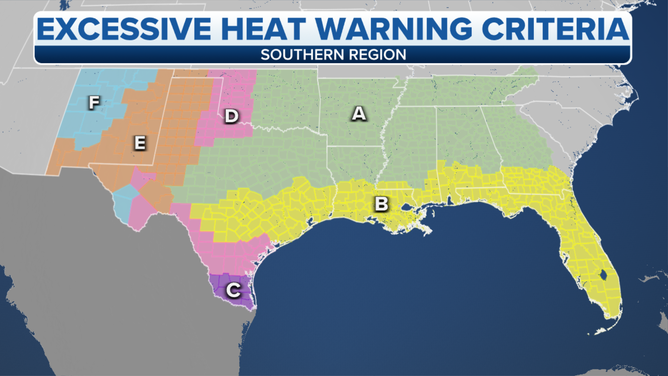
Excessive Heat Warning criteria in the southern U.S. A = temperature of 105 degrees or heat index of 110 degrees. B = temperature of 105 degrees or heat index of 113 degrees. C = temperature or heat index of 116 degrees. D = temperature or heat index of 115 degrees. E = temperature or heat index of 110 degrees. F = temperature or heat index of 105 degrees.
(FOX Weather)
Central US
The following map displays the thresholds used for Heat Advisories in the central U.S.
The red-shaded areas from the central Plains to the Midwest require the hottest conditions to warrant an advisory. Areas shaded in yellow and green to the north and west in the Upper Midwest, northern Plains and the Front Range of the Rockies have lower criteria since those regions don’t typically get as hot, especially in the mountains.
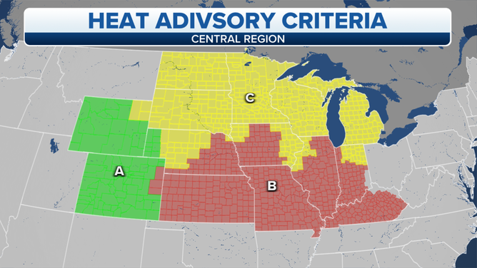
Heat Advisory criteria in the central U.S. A = 100 degrees (Plains) or 95 degrees (mountains). B = 105 degrees. C = 100 degrees.
(FOX Weather)
The next map shows the criteria that must be achieved for Excessive Heat Warnings to be posted.
Similar to the Heat Advisory map above, the red-shaded areas depict the highest thresholds for Excessive Heat Warnings, while the yellow- and green-shaded areas don’t have to be quite as hot for the NWS to issue a warning.
CLICK HERE TO GET THE FOX WEATHER UPDATE PODCAST
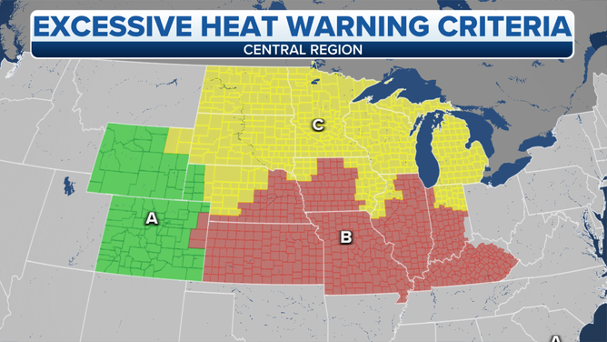
Excessive Heat Warning criteria in the central U.S. A = 105 degrees (Plains) or 100 degrees (mountains). B = 110 degrees. C = 105 degrees.
(FOX Weather)
Western US
Unfortunately, the NWS Western Region does not have a map available showing its heat alert criteria. This is because NWS forecasters in the West use what’s known as "HeatRisk" to determine which type of alert to use.
"At its most basic level, the HeatRisk output at a location is a fractional number that represents the risk of impacts to human health due to excessive heat over a 24-hour period," the NWS wrote in a supplemental publication. "The higher the value, the greater the potential risk."
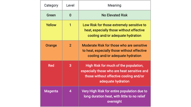
The National Weather Service's HeatRisk forecast is portrayed in a numeric (0-4) and color (green/yellow/orange/red/magenta) scale, which is similar in approach to the Air Quality Index (AQI) or the UV Index.
(National Weather Service)
HeatRisk is calculated by combining the potential heat stresses from both daytime highs and overnight lows, with the overall HeatRisk value increasing when these temperatures are excessive for a particular climate and are at levels that have been shown to be dangerous.
According to the NWS, HeatRisk takes into consideration:
- How far above average the temperatures are at a given location
- Time of year (early-season heat vs. midsummer typical heat)
- Duration of anomalous heat (Do overnight temperatures add to daytime accumulated heat stress or relieve it? Is this a multiday event?)
- If the predicted temperatures are at levels that pose an elevated risk for heat-related illnesses such as heat exhaustion or heatstroke
HOW TO TELL THE DIFFERENCE BETWEEN HEAT EXHAUSTION AND HEATSTROKE
The Centers for Disease Control and Prevention heat health data are also included in the HeatRisk calculations, which contain a national dataset of mortality and morbidity statistics, the NWS noted.
"The HeatRisk approach takes all this into consideration when creating the 24-hour HeatRisk output," the NWS wrote. "While HeatRisk can be an important tool to identify approaching episodes of heat that will have significant impacts on human health, it is also expected to be of value to other sectors where heat plays an important part in driving significant impacts (i.e., agriculture, electrical demand, air quality, recreation, water usage, etc.)."
The table below shows which HeatRisk values correspond with each NWS heat alert, whether it be an Excessive Heat Warning, a Heat Advisory, consideration for an advisory or nothing at all.
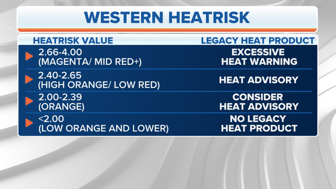
A table showing HeatRisk values and the corresponding heat alert recommended at those values.
(FOX Weather)
You can find the NWS HeatRisk forecast for the next seven days at this link.
An example HeatRisk forecast map for June 10, 2022, is shown below.
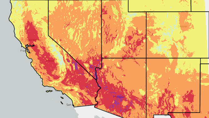
NOT A CURRENT FORECAST – An example of the National Weather Service's HeatRisk forecast for Friday, June 10, 2022.
(National Weather Service)