When is the typical last hurricane strike on the US coast?
The Atlantic hurricane season officially begins on June 1 and ends on November 30.
Here is why hurricane season runs from June to November
Hurricane season is long, why?
The Atlantic basin hurricane season is a 183-day period that runs from June 1 through November 30, but due to seasonal weather pattern changes, some states' statistical likelihood of being impacted by a hurricane runs out long before the season is considered to be officially over.
According to historical data from the National Oceanic and Atmospheric Administration, the latest hurricane ever to make landfall in the Southeast happened on November 21, 1985.
Forecasters considered the strike and strength of Hurricane Kate to be rare, with just nine days left of the season.
A combination of hostile upper-level winds, cooler water temperatures and drier air tends to put an end to tropical development in many areas of the basin.
November ranks fifth out of the six months for seeing the least amount of tropical cyclone development, only running slightly ahead of June’s pace.
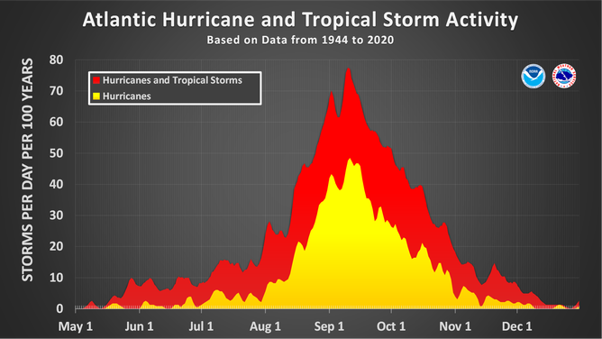
The official hurricane season for the Atlantic Basin (the Atlantic Ocean, Caribbean Sea and Gulf of Mexico) is from June 1 to Nov. 30. As seen in the graph above, the peak of the season is Sept. 10. However, deadly hurricanes can occur anytime in the hurricane season.
(NOAA/NHC)
Some states’ likelihood of directly being impacted wraps up weeks and even more than a month before the season is considered to be officially over.
The addition of cold fronts and ridges of high pressure from Canada during autumn greatly influence the paths of late-season cyclones.
Here’s a breakdown of the hurricanes that hold the distinctions of being the latest in the year to impact states in the Southeast.
WHAT ARE EL NINO AND LA NINA CLIMATE PATTERNS?
Texas - Latest direct landfall: October 16
The latest hurricane to impact the Lone Star State during a season was the unnamed hurricane of 1912.
The cyclone made landfall on the evening of October 16, south of Corpus Christi.
The National Weather Service reported Brownsville experienced winds of 55 mph, and over half a foot of rain fell in 24 hours in southern parts of the state.
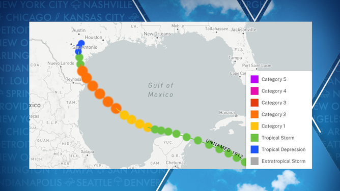
The unnamed hurricane of 1912 strengthened into a Category 2 storm before impacting Texas.
(FOX Weather)
The FOX Forecast Center said the threat of hurricanes usually shuts down for Texas during October because of the changing fall pattern.
If a tropical cyclone doesn’t run into Central America, it is usually pulled north and northeastward and away from the western Gulf.
WATCH A WIND TURBINE DISINTEGRATE IN TEXAS AFTER A LIGHTNING STRIKE
Louisiana - Latest direct landfall: October 29
Louisiana has experienced about two weeks of additional hurricane activity past the statistical date that their neighbors in the Lone Star State bid farewell to hurricanes.
The latest hurricane to impact Louisiana was Hurricane Juan, which made landfall near Morgan City as a Category 1 storm on October 29, 1985.
The NWS said the system’s organization made it similar to a subtropical storm, with the worst of the weather well displaced from the center.
Hurricane made landfall as a Category 1 storm on October 29, 1985.
(NOAA)
Because a trough failed to pick up the system, its track resembled a figure eight, which resulted in a foot of rainfall and impacts for the central and eastern Gulf states.
‘IT UNRAVELS FROM THE BOTTOM’: SCIENTISTS WORK TO SAVE LOUISIANA’S SHRINKING WETLANDS
Mississippi - Latest direct landfall: September 28 (Latest impacts: October 29)
The Magnolia State has the second-smallest coastline of any U.S. state that borders the Gulf. Mississippi is only home to around 80 miles of beaches along the Gulf of Mexico.
This narrow territory means the chances of receiving a direct strike on the coastline are lower than some nearby states, but because hurricanes are usually hundreds of miles wide, a direct strike is not needed to see significant impacts.
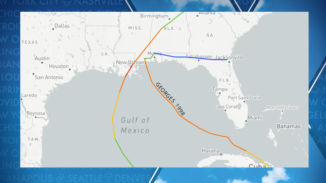
Hurricane Georges in September 1998 holds the record of being the latest significant cyclone to make a direct landfall in the state.
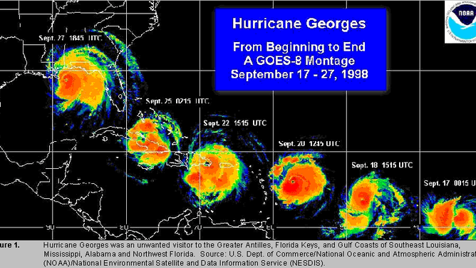
Hurricane Georges Satellite Track (1998)
(FOX Weather)
On September 28, the hurricane produced a storm surge of 7 – 12 feet and winds that were just shy of Category 3 strength.
The cyclone caused billions of dollars in damage but is not the latest in the calendar year to impact the state.
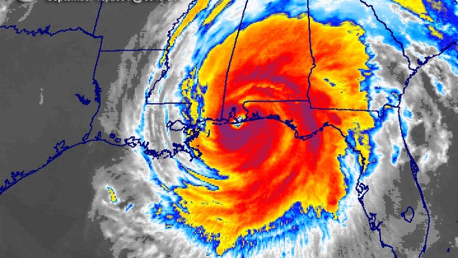
The latest in-season hurricane to affect Mississippi was Zeta in 2020.
Hurricane Zeta made landfall as a Category 3 on October 28 in nearby Louisiana but traveled over the state in the hours afterward.
The NHC reported Zeta had sustained winds of around 90 mph when it impacted Mississippi.
Mississippi latest hurricane impacts
(FOX Weather)
HURRICANE CAMILLE, ONE OF THE WORLD’S WORST STORMS, PUMMELED THE US 53 YEARS AGO
Alabama - Latest direct landfall: September 16 (Latest impacts: October 29)
Alabama is home to the shortest coastline of any state on the Gulf Coast. Beaches only extend for about 60 miles along the Gulf of Mexico.
Similarly, to Mississippi, the chances of receiving a direct strike on the Alabama coastline are lower because of the lack of square miles, but a direct landfall is not needed to see significant impacts.
The latest in-season landfall in Alabama by a hurricane was Ivan in 2004. The hurricane made landfall as a devastating Category 3 on September 16.
Ivan caused an estimated $13 billion in damage in the U.S., making it one of the costliest storms at the time.
At 1:50 a.m. on September 16, 2004, Hurricane Ivan made landfall just west of Gulf Shores, Alabama.
(NOAA)
The state has been walloped by many hurricanes that have made landfall in nearby Florida, Mississippi and Louisiana.
Back in 2020, Hurricane Zeta made landfall as a Category 3 storm along the Louisiana coast, but because of the system’s fast-forward speed, it was still considered a hurricane when it reached inland Alabama.
Hurricane conditions were experienced between Mobile and Tuscaloosa during the early morning hours of October 29.
These conditions from Zeta made the storm the latest during any calendar year to produce sustained winds over 74 mph in Alabama.
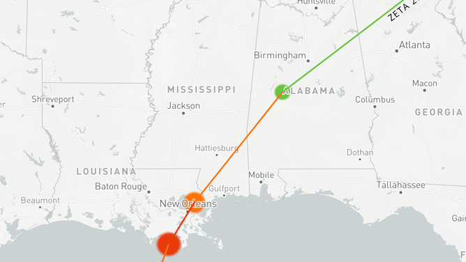
Hurricane Zeta 2020 path
CENTRAL AMERICA IS PRONE TO HURRICANE DISASTERS
Florida (Latest direct landfall: November 21)
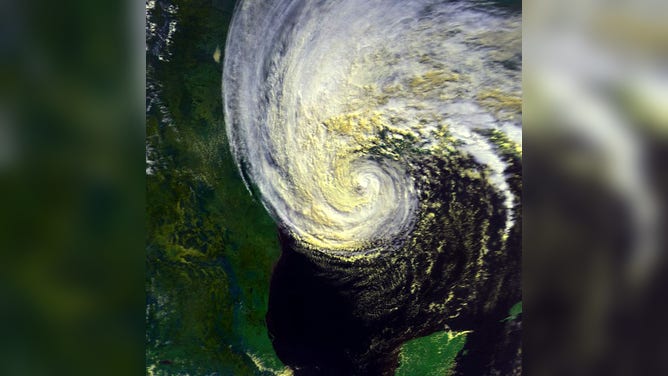
Hurricane Kate of 1985 holds several records in weather history. The Category 2 storm is the strongest and latest to have impacted the lower 48 during any season.
The cyclone had a complicated beginning and formed because a stout ridge over the southwest Atlantic kept fall’s usual fronts further north.
Kate moved through the Bahamas and Cuba before entering the Gulf of Mexico.
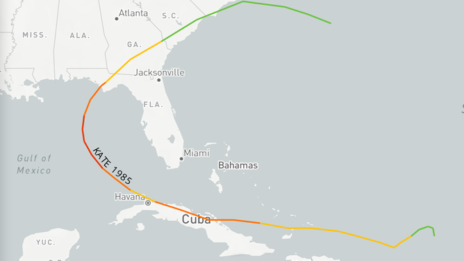
Hurricane Kate Track 1985
It was in the eastern Gulf, that the cyclone became a Category 3 hurricane with winds in excess of 115 mph.
Its strength alone was a rare feat in November due to usually cooler water temperatures and hostile upper-level winds, which prevent cyclone strengthening.
A cold front was able to help turn and pull the storm northward, and it made landfall along the Florida Panhandle as a weakening Category 2 storm on November 21.
The hurricane caused damage that would be estimated to be around $1.9 billion in today’s dollar value.
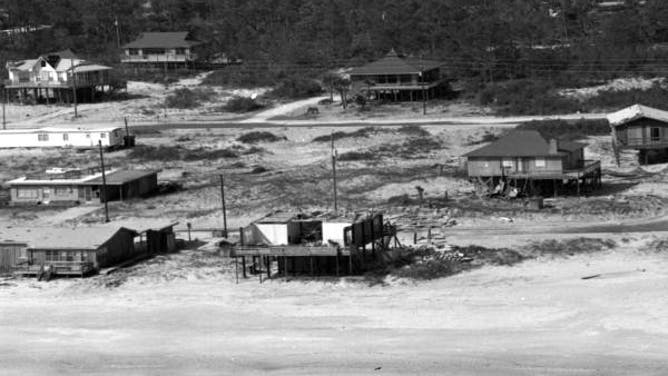
![Hurricane Kate]() Image 1 of 3
Image 1 of 3Hurricane Kate impacted the Florida Panhandle and Tallahassee. (Florida Memory)
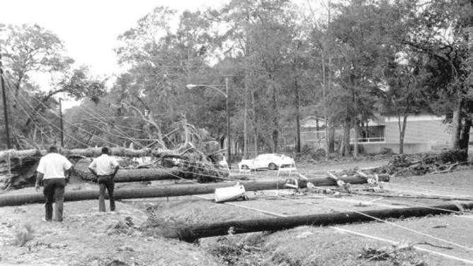
![Hurricane Kate]() Image 2 of 3
Image 2 of 3Hurricane Kate impacted the Florida Panhandle and Tallahassee. (Florida Memory)
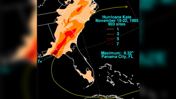
![Hurricane Kate track and rainfall]() Image 3 of 3
Image 3 of 3Hurricane Kate track and rainfall (NOAA)
Despite the tremendous devastation from the Caribbean to Florida, the storm’s name was not retired from a repeating list of identifications used by the World Meteorological Organization.
"Kate" was used to name cyclones in 2003, 2015, 2021 and will again be available to be used in 2027.
KNOW YOUR ZONE: FLORIDA EVACUATION MAP SHOWS WHO WILL HAVE TO LEAVE BEFORE A HURRICANE STRIKES
Georgia (Latest direct landfall: October 15; Latest impact: November 22)
The Peach State is similar to Mississippi and Alabama in that hurricane conditions can be experienced without seeing a direct landfall.
The latest direct landfall in Georgia was the unnamed hurricane of 1947. The storm, which is sometimes referred to as "Hurricane King," made landfall south of Savannah on October 15.
The storm developed on October 9 off the coast of Nicaragua and, similar to many other late-season storms, had an erratic path to Georgia.
Meteorologists considered the storm to be small, with hurricane-force winds that only extended outwards 40 miles when it impacted the Savannah region.
Due to the state’s curved nature and short coastline, direct strikes to Georgia are rare. The state is home to a little more than 100 miles of coast along the Atlantic Ocean.

Georgia Hurricane Strikes
(FOX Weather)
Because Georgia is only a hop, skip and jump away from the Gulf of Mexico, the state can also be impacted by Gulf Coast storms.
That is exactly was happened in November of 1985. After Hurricane Kate made landfall along the Florida Panhandle, it moved inland over Georgia, producing winds of around 75 mph on the morning of November 22.
So while Kate was not a direct landfall, it does hold the record for producing the latest hurricane conditions in a season in the Peach State
MILLIONS OF BEES DIE FROM HEAT ON TARMAC AT ATLANTA’S AIRPORT
South Carolina (Latest direct landfall: October 31)
The exact landfall location of the unnamed hurricane of 1889 is unknown. Data commonly used by the NHC showed the Category 2 storm made landfall near Myrtle Beach on October 31, but an NWS summary put the strike location much further north.
The cyclone initially formed in the Caribbean Sea on September 23 and moved north, passing over Cuba and then up to the Carolina coast.
Winds were estimated to be over 100 miles an hour, and the storm surge was significant. The NWS reported the water rise was estimated to be 8 feet, flooding several coastal towns.
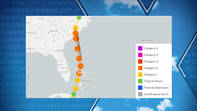
Track of an unnamed hurricane in 1889
(FOX Weather)
SOUTH CAROLINA EPICENTER OF EARTHQUAKE SEQUENCE
North Carolina (Latest direct landfall: November 2)
An unnamed hurricane on November 2, 1861, is the latest event in the calendar year to impact the Tar Heel State.
The cyclone originally formed in the Gulf of Mexico, made landfall in Florida, crossed into the Atlantic and strengthened into a hurricane before impacting North Carolina.
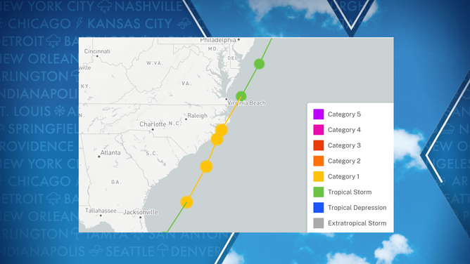
November 1861 hurricane track
(FOX Weather)
A common nickname for the storm is the "Expedition Hurricane" as the hurricane is said to have impacted the expedition of warships during the Civil War.
The North Carolina landfall produced winds that were thought to have been Category 1 strength on the Saffir-Simpson Hurricane Wind Scale.
HOW ARE HURRICANES RATED? THE SAFFIR-SIMPSON HURRICANE WIND SCALE EXPLAINED