Dramatic images show power of severe storms in South after tornadoes reported
Video and photos tell the story of storm damage in Arkansas and Louisiana as the start of a multiday severe weather outbreak continues into Tuesday and Wednesday.
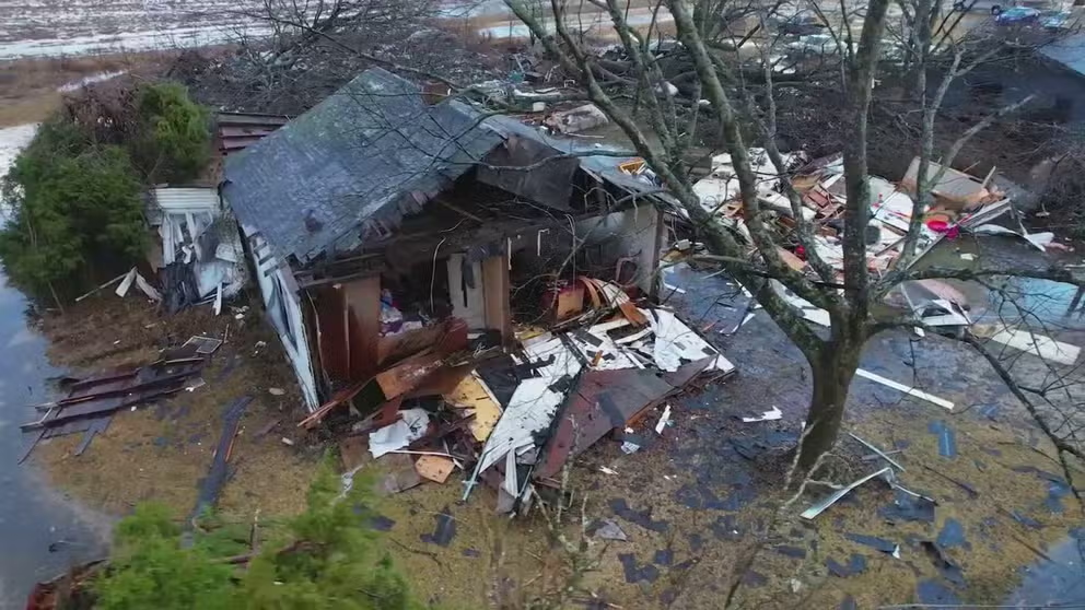
Daylight reveals scope of damage in Montrose, Arkansas from tornado
Video from Tuesday morning reveals the scope of damage in Montrose, Arkansas from a tornado on Monday night.
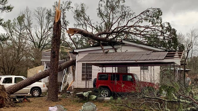
The South was slammed after a dangerous and multiday severe weather outbreak began its trek Monday across Louisiana and Arkansas, and there's more nasty weather on tap for the region Tuesday.
Several tornadoes were reported, and dramatic images show how damaging the storms were.
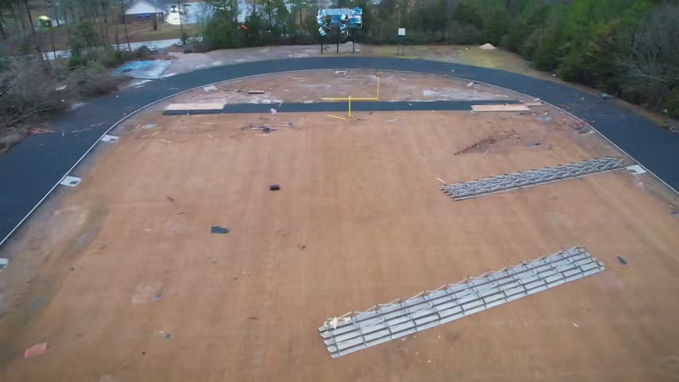
Drone footage shows damage to Arkansas high school from apparent tornado
Drone video captures damage to a high school in Jessieville, Arkansas from an apparent tornado.
An apparent tornado twisted its way through Jessieville High School near Hot Springs, Arkansas, about 2:45 p.m. Monday, according to the Garland County Sheriff's Office.
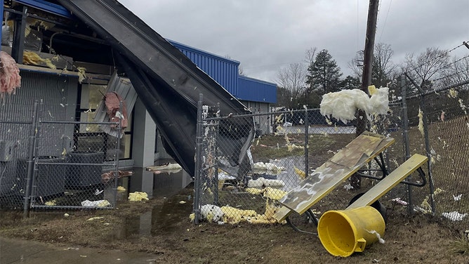
The band building was no match for the winds.
(@DPierceretired/Twitter)
Bleachers were tossed about, and stadium light poles were snapped in half as the apparent twister rolled across the football field, eventually damaging nearby classrooms and adjacent homes.
![Tornado hits school in Hot Springs, AR]() Image 1 of 31
Image 1 of 31An apparent tornado twisted its way through Jessieville High School near Hot Springs, Arkansas, Monday afternoon, according to the Garland County Sheriff's Office. (Garland County Sheriff's Office/Facebook)
![Tornado hits school in Hot Springs, AR]() Image 2 of 31
Image 2 of 31An apparent tornado twisted its way through Jessieville High School near Hot Springs, Arkansas, Monday afternoon, according to the Garland County Sheriff's Office. (Garland County Sheriff's Office/Facebook)
![Tornado hits school in Hot Springs, AR]() Image 3 of 31
Image 3 of 31An apparent tornado twisted its way through Jessieville High School near Hot Springs, Arkansas, Monday afternoon, according to the Garland County Sheriff's Office. (Garland County Sheriff's Office/Facebook)
![Tornado hits school in Hot Springs, AR]() Image 4 of 31
Image 4 of 31An apparent tornado twisted its way through Jessieville High School near Hot Springs, Arkansas, Monday afternoon, according to the Garland County Sheriff's Office. (Garland County Sheriff's Office/Facebook)
![Tornado hits school in Hot Springs, AR]() Image 5 of 31
Image 5 of 31An apparent tornado twisted its way through Jessieville High School near Hot Springs, Arkansas, Monday afternoon, according to the Garland County Sheriff's Office. (Garland County Sheriff's Office/Facebook)
![Tornado hits school in Hot Springs, AR]() Image 6 of 31
Image 6 of 31An apparent tornado twisted its way through Jessieville High School near Hot Springs, Arkansas, Monday afternoon, according to the Garland County Sheriff's Office. (Garland County Sheriff's Office/Facebook)
![Tornado hits school in Hot Springs, AR]() Image 7 of 31
Image 7 of 31An apparent tornado twisted its way through Jessieville High School near Hot Springs, Arkansas, Monday afternoon, according to the Garland County Sheriff's Office. (Garland County Sheriff's Office/Facebook)
![Tornado hits school in Hot Springs, AR]() Image 8 of 31
Image 8 of 31An apparent tornado twisted its way through Jessieville High School near Hot Springs, Arkansas, Monday afternoon, according to the Garland County Sheriff's Office. (Garland County Sheriff's Office/Facebook)
![Tornado hits school in Hot Springs, AR]() Image 9 of 31
Image 9 of 31An apparent tornado twisted its way through Jessieville High School near Hot Springs, Arkansas, Monday afternoon, according to the Garland County Sheriff's Office. (Garland County Sheriff's Office/Facebook)
![Tornado hits school in Hot Springs, AR]() Image 10 of 31
Image 10 of 31An apparent tornado twisted its way through Jessieville High School near Hot Springs, Arkansas, Monday afternoon, according to the Garland County Sheriff's Office. (Garland County Sheriff's Office/Facebook)
![Tornado hits school in Hot Springs, AR]() Image 11 of 31
Image 11 of 31An apparent tornado twisted its way through Jessieville High School near Hot Springs, Arkansas, Monday afternoon, according to the Garland County Sheriff's Office. (Garland County Sheriff's Office/Facebook)
![Tornado hits school in Hot Springs, AR]() Image 12 of 31
Image 12 of 31An apparent tornado twisted its way through Jessieville High School near Hot Springs, Arkansas, Monday afternoon, according to the Garland County Sheriff's Office. (Garland County Sheriff's Office/Facebook)
![Tornado hits school in Hot Springs, AR]() Image 13 of 31
Image 13 of 31An apparent tornado twisted its way through Jessieville High School near Hot Springs, Arkansas, Monday afternoon, according to the Garland County Sheriff's Office. (Garland County Sheriff's Office/Facebook)
![Tornado hits school in Hot Springs, AR]() Image 14 of 31
Image 14 of 31An apparent tornado twisted its way through Jessieville High School near Hot Springs, Arkansas, Monday afternoon, according to the Garland County Sheriff's Office. (Garland County Sheriff's Office/Facebook)
![Tornado hits school in Hot Springs, AR]() Image 15 of 31
Image 15 of 31An apparent tornado twisted its way through Jessieville High School near Hot Springs, Arkansas, Monday afternoon, according to the Garland County Sheriff's Office. (Garland County Sheriff's Office/Facebook)
![Tornado hits school in Hot Springs, AR]() Image 16 of 31
Image 16 of 31An apparent tornado twisted its way through Jessieville High School near Hot Springs, Arkansas, Monday afternoon, according to the Garland County Sheriff's Office. (Garland County Sheriff's Office/Facebook)
![Tornado hits school in Hot Springs, AR]() Image 17 of 31
Image 17 of 31An apparent tornado twisted its way through Jessieville High School near Hot Springs, Arkansas, Monday afternoon, according to the Garland County Sheriff's Office. (Garland County Sheriff's Office/Facebook)
![Tornado hits school in Hot Springs, AR]() Image 18 of 31
Image 18 of 31An apparent tornado twisted its way through Jessieville High School near Hot Springs, Arkansas, Monday afternoon, according to the Garland County Sheriff's Office. (Garland County Sheriff's Office/Facebook)
![Tornado hits school in Hot Springs, AR]() Image 19 of 31
Image 19 of 31An apparent tornado twisted its way through Jessieville High School near Hot Springs, Arkansas, Monday afternoon, according to the Garland County Sheriff's Office. (Garland County Sheriff's Office/Facebook)
![Tornado hits school in Hot Springs, AR]() Image 20 of 31
Image 20 of 31An apparent tornado twisted its way through Jessieville High School near Hot Springs, Arkansas, Monday afternoon, according to the Garland County Sheriff's Office. (Garland County Sheriff's Office/Facebook)
![Tornado hits school in Hot Springs, AR]() Image 21 of 31
Image 21 of 31An apparent tornado twisted its way through Jessieville High School near Hot Springs, Arkansas, Monday afternoon, according to the Garland County Sheriff's Office. (Garland County Sheriff's Office/Facebook)
![Tornado hits school in Hot Springs, AR]() Image 22 of 31
Image 22 of 31An apparent tornado twisted its way through Jessieville High School near Hot Springs, Arkansas, Monday afternoon, according to the Garland County Sheriff's Office. (Garland County Sheriff's Office/Facebook)
![Tornado hits school in Hot Springs, AR]() Image 23 of 31
Image 23 of 31An apparent tornado twisted its way through Jessieville High School near Hot Springs, Arkansas, Monday afternoon, according to the Garland County Sheriff's Office. (Garland County Sheriff's Office/Facebook)
![Tornado hits school in Hot Springs, AR]() Image 24 of 31
Image 24 of 31An apparent tornado twisted its way through Jessieville High School near Hot Springs, Arkansas, Monday afternoon, according to the Garland County Sheriff's Office. (Garland County Sheriff's Office/Facebook)
![Tornado hits school in Hot Springs, AR]() Image 25 of 31
Image 25 of 31An apparent tornado twisted its way through Jessieville High School near Hot Springs, Arkansas, Monday afternoon, according to the Garland County Sheriff's Office. (Garland County Sheriff's Office/Facebook)
![Tornado hits school in Hot Springs, AR]() Image 26 of 31
Image 26 of 31An apparent tornado twisted its way through Jessieville High School near Hot Springs, Arkansas, Monday afternoon, according to the Garland County Sheriff's Office. (Garland County Sheriff's Office/Facebook)
![Tornado hits school in Hot Springs, AR]() Image 27 of 31
Image 27 of 31An apparent tornado twisted its way through Jessieville High School near Hot Springs, Arkansas, Monday afternoon, according to the Garland County Sheriff's Office. (Garland County Sheriff's Office/Facebook)
![Tornado hits school in Hot Springs, AR]() Image 28 of 31
Image 28 of 31An apparent tornado twisted its way through Jessieville High School near Hot Springs, Arkansas, Monday afternoon, according to the Garland County Sheriff's Office. (Garland County Sheriff's Office/Facebook)
![Tornado hits school in Hot Springs, AR]() Image 29 of 31
Image 29 of 31An apparent tornado twisted its way through Jessieville High School near Hot Springs, Arkansas, Monday afternoon, according to the Garland County Sheriff's Office. (Garland County Sheriff's Office/Facebook)
![Tornado hits school in Hot Springs, AR]() Image 30 of 31
Image 30 of 31An apparent tornado twisted its way through Jessieville High School near Hot Springs, Arkansas, Monday afternoon, according to the Garland County Sheriff's Office. (Garland County Sheriff's Office/Facebook)
![Tornado hits school in Hot Springs, AR]() Image 31 of 31
Image 31 of 31An apparent tornado twisted its way through Jessieville High School near Hot Springs, Arkansas, Monday afternoon, according to the Garland County Sheriff's Office. (Garland County Sheriff's Office/Facebook)


The sheriff's office said school was in session at the time, though all students were accounted for and there were no reports of injuries.
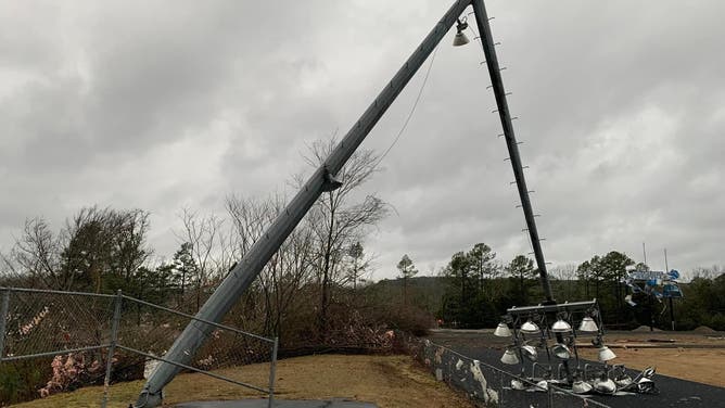
An apparent tornado twisted its way through Jessieville High School near Hot Springs, Arkansas, Monday afternoon, according to the Garland County Sheriff's Office.
(Garland County Sheriff's Office/Facebook)
"A home located at 8000 Highway 7N experienced severe damage along with a few other homes in the area," the sheriff's office said. "The area has been evacuated and all residence have been accounted for and reports of no injury have been made."
An apparent tornado twisted its way near Hot Springs, Arkansas, Monday afternoon.
(Garland County Sheriff's Office/Facebook)
Footage captured by Jaden Pappenheim showed a dark funnel cloud forming east of Jonesboro, Louisiana, in Jackson Parish.
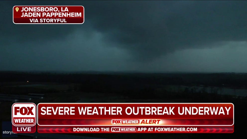
Dark funnel spotted over Jonesboro, Louisiana
A dark funnel cloud is captured looming over Jonesboro, Louisiana on Monday.
On Tuesday morning, the National Weather Service told residents in Louisville, Kentucky, to avoid driving through flooded and closed roads and stay tuned for the latest weather alerts as the severe and flood risks continue into the evening.
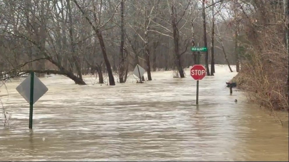
Debris swept through rushing floodwater in Kentucky
Video posted by photographer Kurtis Ryan Coady on Tuesday shows debris, including a hay bale and trash can, rushing through floodwater after heavy rains in Fisherville.
Kurtis Ryan Coady posted video on Tuesday showing debris, including a hay bale and trash can, rushing through floodwater after heavy rains in Fisherville.