NASA satellite shows just how big Death Valley's ghost lake really was
Hurricane Hilary and the intense winter atmospheric river storms flooded salt flats in the desert of Death Valley National Park, the driest place in North America.
Atmospheric rivers bring lake to Death Valley National Park
Abby Wines, park ranger with Death Valley National Park, explains how a temporary lake was able to form in California's Death Valley National Park. The lake is deep enough that some people have kayaked on it. Feb. 21, 2024.
DEATH VALLEY, Calif. – The National Park Service recently announced that there will be no more boating at the driest place on the continent because a lake that appeared in Death Valley is disappearing, but NASA has released satellite images showing exactly how big the so-called ghost lake was.
Death Valley National Park averages just 2 inches of rain and 130 inches of evaporation a year, but it has been a boating mecca for inland kayakers since summer after a lake reappeared 10,000 years after going extinct.
CHILLING IRONY: HOW WORLD HEAT CHAMP DEATH VALLEY OWES NAME, IN PART, TO A SNOWSTORM
![]() Image 1 of 2
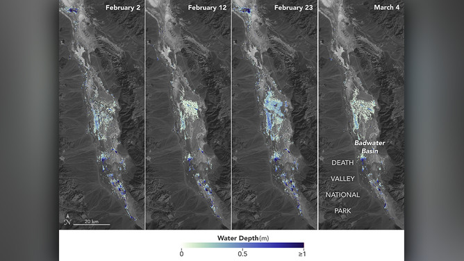
Image 1 of 2Satellite estimates of the depth of Manly Lake from February 2 to March 4. ( )
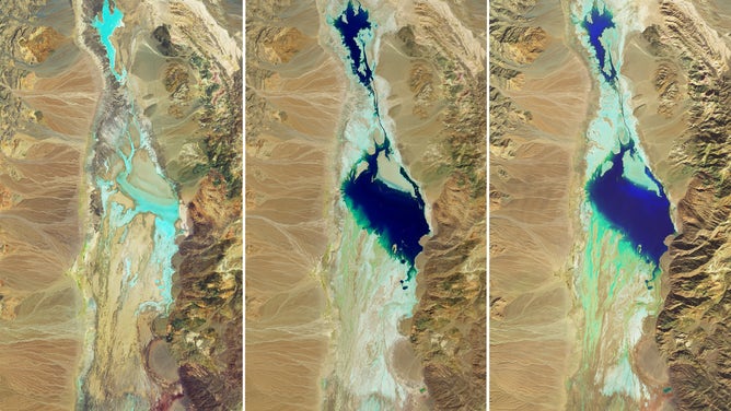
![A series of NASA satellite images show Lake Manly in the Badwater Basin at Death Valley National Park.]() Image 2 of 2
Image 2 of 2A series of NASA satellite images show Lake Manly in the Badwater Basin at Death Valley National Park. (NASA Earth Observatory images by Wanmei Liang, using Landsat data from the U.S. Geological Survey)
Lake Manly is an extinct lake
The lake dubbed "Lake Manly" began developing during Hurricane Hilary. The monster Category 4 storm slammed Mexico in August 2023 and continued into California. The National Hurricane Center issued its first-ever Tropical Storm Warning for Southern California. In just one day, it dropped more than a year's worth of rain. The floodwater rushed into almost every basin in the national park.
DEATH VALLEY NATIONAL PARK TRANSFORMS INTO LAND OF EPHEMERAL LAKES AFTER HURRICANE HILARY
Photos showing the ghost lake in 2024 compared to the dry salt flat in 2021.
(DAVID SWANSON/AFP, David Butow/Corbis, Andia/Universal Images Group, NPS / K. Skilling / Getty Images)
"The most notable one is the one at Badwater Basin," Matthew Lamar, park ranger at Death Valley National Park, told FOX Weather in November.
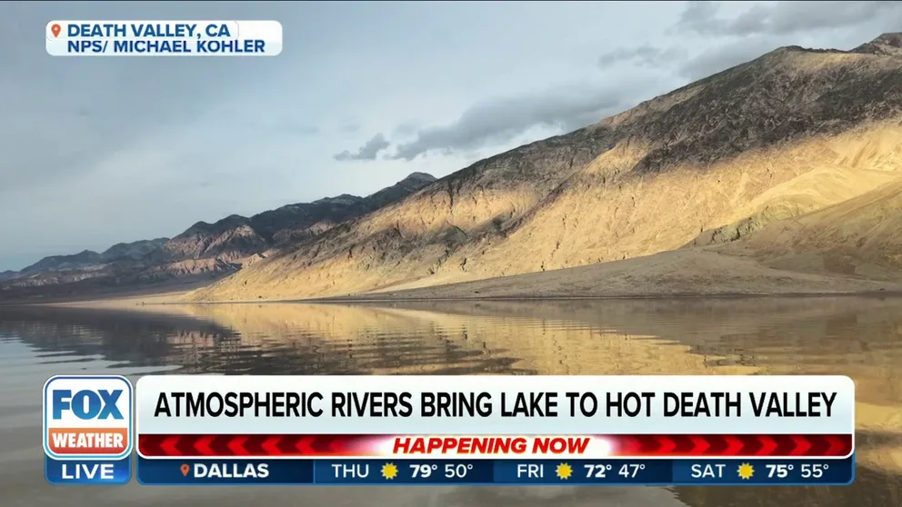
Badwater Basin, a salt flat 282 feet below sea level and as far as the eye can see, is the lowest point in North America, according to Lamar. He said it filled with 2 feet of water after the storm, but since the area is normally a desert, there were no permanent instruments to measure it. Rangers and park visitors judged the depth by wading into the water.
DEATH VALLEY REOPENS 195 MILES OF ROADS DAMAGED BY HURRICANE HILARY
By November, the lake was down to a couple of inches, he said. Then came the winter of 51 atmospheric rivers which drenched the West Coast. February soakers dropped another three-quarters of a year's worth of rain in a day, and kayakers set sail again.
ATMOSPHERIC RIVER DROPS SNOW, FLOODS ROADS IN DEATH VALLEY NATIONAL PARK

File: Kayaking at Badwater Basin on February 9, 2024. (Photo: NPS/Michael Kohler)
(NPS / FOX Weather)
No instruments to measure water depth in desert
NASA used the U.S.-French Surface Water and Ocean Topography satellite to measure the depth of the ephemeral lake. Over six weeks, from Feb. 2 to March 4, the water ranged from 3 feet to 1.5 feet deep. Analysts used the satellite to measure the elevation of the water's surface and combined it with U.S. Geological Survey data about the basin.
The images from NASA tell the tale of the stormy February and windy March.
KAYAKING HALTED IN DEATH VALLEY AS POWERFUL WINDS BLOW TEMPORARY LAKE 2 MILES NORTH
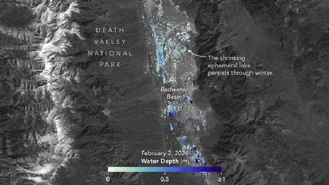
The water depth shown is in meters. NASA explained the influx of new water.
(NASA)
"The researchers found that the water levels varied across space and time in the roughly 10-day period between SWOT observations. Right after a series of storms in early February, the temporary lake was about 6 miles (10 kilometers) long and 3 miles (5 kilometers) widest," wrote NASA in a statement. "Each pixel in the image represents an area that is about 330 feet by 330 feet (100 meters by 100 meters)."
Another storm brought strong winds to Death Valley between Feb. 29 and March 4. The winds moved the shallow lake a couple of miles. That was when kayaking was temporarily halted. Sunday, the park closed the "lake" for boating.
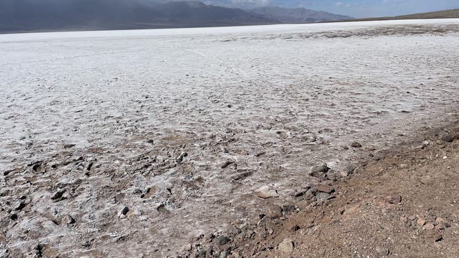
File: Footprints in the mud scar the landscape and those footprints won't go away until the next time the prehistoric lake floods.
(Abby Wines / NPS / FOX Weather)
Don't even leave your footprints behind
"'Lake Manly,' the temporary shallow lake at Badwater Basin (formed after storms in August 2023 and February 2024) is shrinking rapidly and is now only a few inches deep. It is a minimum of 1/4 mile away from the road over rough, uneven salt and mud (no trail)," the NPS posted. "Due to the shallow depth of the lake and the damage caused by people dragging watercraft across the salt flats, the lake is closed to all boating (kayaks, paddleboards, canoes, pool floats etc.)."
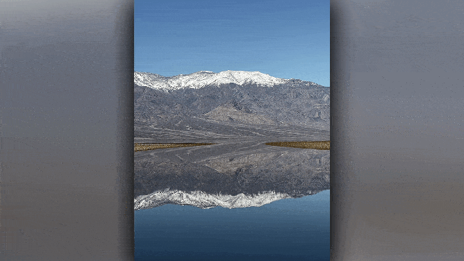
Visitors can still walk in the water and enjoy the mountain reflections, though. However, park officials prohibit anyone from walking in the mud and leaving footprints, which will scar the landscape until the next wild weather event causes the lake to reappear.