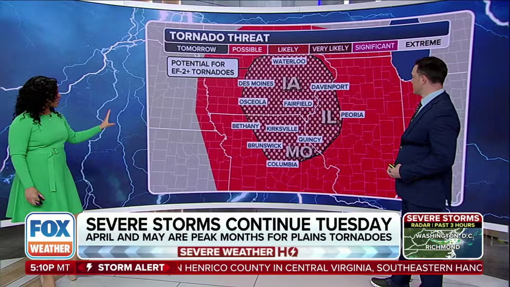
Severe storm threat for Midwest sets up 'very likely' EF-2 tornado risk in Iowa, Missouri, Illinois on Tuesday
A couple of rounds of severe weather are forecast Tuesday as the threat moves into America's heartland. Storms are also expected Wednesday in the Ohio Valley.
Storms continue to pop during the overnight setting up an early Tuesday strong tornado threat
Chicago, St. Louis, Little Rock and Des Moines are in the tornado and hail bullseye on Tuesday. Storms will continue to rumble overnight delivering an early threat.
Severe thunderstorms are firing off this week across the Plains and Midwest, bringing the potential for baseball-sized hail, damaging wind gusts, tornadoes and heavy downpours across America's heartland.
April is typically the second-most-active month for severe weather, and this year is no exception. The month has already featured its share of damaging storms, and that active pattern is expected to continue heading into the second half of the month.
This week, a multiday severe weather threat is unfolding across areas from Texas to Ohio. The first round of storms kicked off late Monday across the Plains. The threat shifts eastward into the Midwest on Tuesday. By Wednesday, scattered thunderstorms roll into the Ohio Valley and mid-South.

(FOX Weather)
Tuesday's threat centered over Iowa, northern Missouri, Illinois, northwestern Illinois
An atmospheric cap kept storms at bay for most of Monday, but the atmosphere became more primed for severe weather overnight and into Tuesday.
NOAA's Storm Prediction Center (SPC) has posted a Level 3 out of 5 risk of severe weather Tuesday across portions of the Midwest. The SPC warned of the potential of EF-2 tornadoes or stronger, wind gusts up to 70 mph and tennis ball-sized hail.
APRIL KICKS OFF AMERICA'S MOST ACTIVE TIME OF YEAR FOR TORNADOES

(FOX Weather)
"The atmosphere certainly would support hail up to 2.5 inches in diameter," Shawn Jacobs, Warning Coordination Meteorologist at the National Weather Service office in North Platte, Nebraska, told FOX Weather. "And, you know, those hailstones can fall at over 100 mph. So you certainly don't want to be caught outside in a hail storm producing 2.5 in hail."
A second round of severe weather gets started Tuesday afternoon into the evening and pushes farther east.
WHAT IS A DRYLINE AND WHY ITS LOCATION IMPORTANT IN SEVERE WEATHER FORECASTING?

(FOX Weather)
Chicago in Illinois faces a Level 2 out of 5 risk, along with Kansas City and St. Louis in Missouri and Little Rock in Arkansas. Northeast Missouri, eastern Iowa and northwest Illinois are in a Level 3 out of 5 threat.
While that region might face the greatest threat of damaging storms, the overall severe weather risk on Tuesday encompasses more than 47 million people from southern Minnesota and southern Wisconsin through northeastern Texas and northwestern Louisiana.
Thunderstorms move into Ohio Valley, southern Michigan by Wednesday
On Wednesday afternoon, scattered thunderstorms are possible across parts of Michigan, Indiana, Ohio, Kentucky and Tennessee. The SPC issued a Level 2 out of 5 risk for areas of Indiana, Ohio and Louisville andKentucky.

(FOX Weather)
Once again, the timing for storms begins Wednesday afternoon and will continue into the evening hours.
The highlighted area may experience a mix of severe hazards, including hail, wind, heavy rain and tornadoes.
Only eastern Oklahoma remains in the Level 2 of 5 threat for Thursday.
Heavy rain could lead to flooding in some areas
The FOX Forecast Center expects intense downpours with these storms through midweek, with 1-2 inches of rain possible in places like Nebraska, Iowa and Wisconsin. Isolated areas in northwestern Iowa could see up to 4 inches of rainfall locally.
This increase in moisture over a short period of time will create the ingredients for potential flooding in some areas.

(FOX Weather)