Back-to-back winter storms bringing measurable snow, rain to Pacific Northwest
FOX Forecast Center is tracking two winter weather systems bringing measurable snow and rain across most of the West Coast.
Winter storm could bring measurable snow from Seattle to California's Sierra Nevada
Seattle has been placed under a Winter Weather Advisory, while Winter Storm Watches and Warnings cover much of the Cascades and Sierra Nevada.
A cold front moving into the Northwest U.S. on Tuesday is forecast to bring high wind gusts, snow and rain to areas from Seattle into the Sierra Nevada mountains.
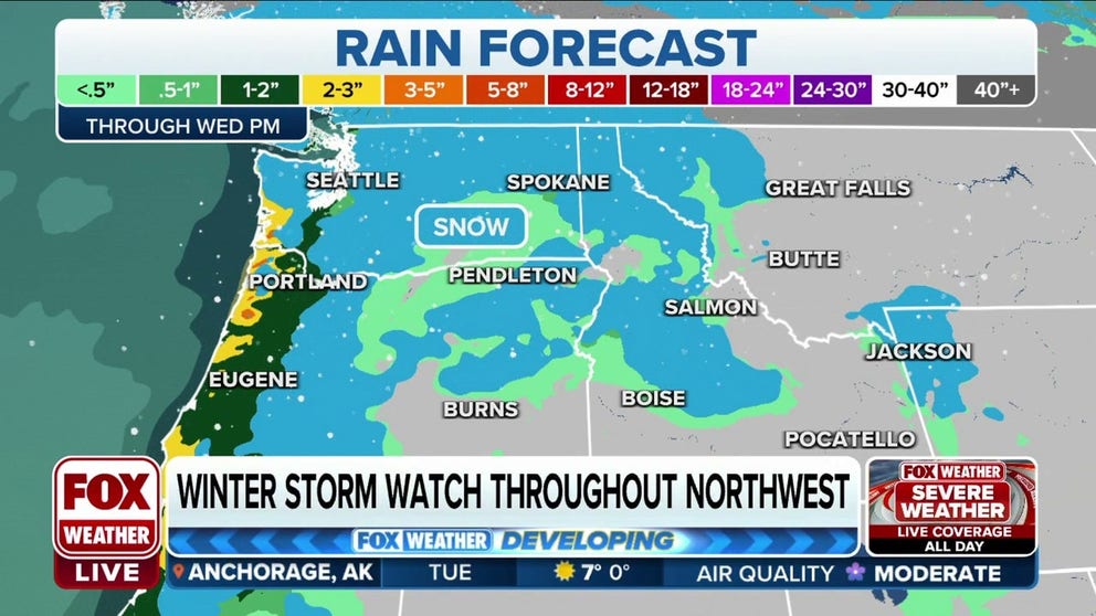
The system is the first of two rounds of rain and snow the FOX Forecast Center is tracking across the West Coast that will impact the Pacific Northwest early in the week and most of California later in the week and through the weekend.
Washington and Oregon

(FOX Weather)
Snow showers were moving over Seattle and surrounding areas by late Tuesday morning and are expected to continue throughout the day before transitioning to rain.
The highest levels of snowfall are forecast north of Seattle.
Areas including the Cascades and the valleys of Whatcom and Skagit counties are forecast to see accumulations of 1 to 2 feet in higher elevations through Wednesday afternoon.
A Winter Storm Warning is in effect through Saturday for parts of Northern California, Oregon, Washington, Idaho and Montana.
The National Weather Service issued wind alerts, including a High Wind Warning near Bellingham, Washington, through Wednesday morning. High Wind Watches remain in effect for coastal areas from Astoria down to Gold Beach, Oregon.
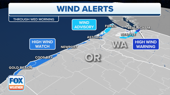
Wind Alerts are in effect through Wednesday for parts of the Pacific Northwest, including Seattle.
(FOX Weather)
Winds gusting as high as 50 mph, combined with snowfall, may make travel difficult for evening commuters and school dismissal through Wednesday evening.
WHICH IS THE SNOWIEST MONTH OF THE YEAR?
As the snow began to stick to roads, Washington Department of Transportation officials reported crashes on Tuesday on eastbound State Road 516 in Kent, Washington, and State Road 96.
Up to a foot of snow is forecast Tuesday for the Snoqualmie Pass.
"You feel how cold it is outside, so this is going to impact that snow level, and that's a concern for traveling over the mountain passes today," FOX Weather meteorologist Britta Merwin said.
California
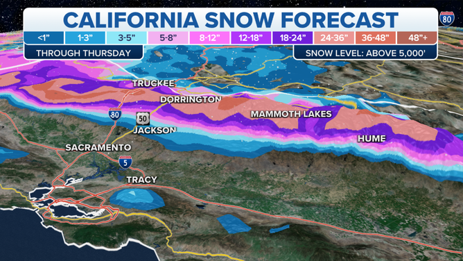
California snow forecast through Thursday.
(FOX Weather)
The first round of winter weather will bring significant snow to Northern and Central California and across the Sierra Nevada through Thursday.
Areas above 5,000 feet, including Mammoth Lakes, could see several feet of snow.
ERUPTION OF HAWAII’S MAUNA LOA VOLCANO SENDS LAVA SHOOTING HUNDREDS OF FEET INTO THE AIR
On the heels of the first system, a second will move farther south Friday, bringing another heavy dose of rain and snow to Northern California and the Sierra Nevada.
Meanwhile, Central and Southern California will see widespread rain later this week.
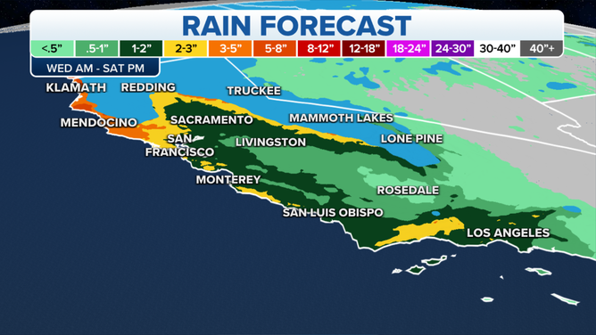
Western rain forecast through Saturday night.
(FOX Weather)
Rain showers are forecast to begin in Los Angeles on Thursday, bringing up to 2 inches of rainfall through Saturday.
Good news for mountain snowpack
The back-to-back winter weather will help the mountain snowpack west of the Continental Divide continue to build for the fall.
So far, most mountains have seen between 100% and 300% of average snow to date. The snow is not as high east of the divide, between 60% and 120% of average, but still a promising start.