Looking for rain or snow? Here's why you won't find much across the US on Tuesday
An eerily quiet weather pattern like this one tends to happen a few days each year, and fall is the time of year when it's most expected because of cool, Canadian air beginning to infiltrate the U.S., the FOX Forecast Center said.

Windy days ahead in Plains
A High Wind Warning is in effect for the Laramie Mountain range and a large part of Big Sky country in Montana. Winds will be out of the west from 30 to 40 mph, with gusts up to 60 mph, the National Weather Service said.
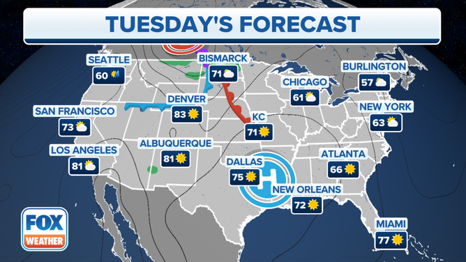
The weather map across the U.S. is nearly blank on Tuesday due to the lack of significant storm systems.
An eerily quiet weather pattern like this one tends to happen a few days each year, and fall is the time of year when it's most expected because of cool, Canadian air beginning to infiltrate the U.S., the FOX Forecast Center said.
The only rain showers in the nation can be found along the U.S.-Canada border from Montana to North Dakota and the coast of Washington state, as seen below on a three-hour radar loop tracking ongoing showers and thunderstorms.
AUTUMN CHILL HAS MORNING TEMPERATURES TUMBLING INTO THE 40S FROM THE PLAINS TO EAST COAST

(FOX Weather)
The only impactful weather expected on Tuesday is high winds in parts of Montana, Wyoming and South Dakota, where High Wind Warnings and Wind Advisories are in effect.
"Where we're talking about these stronger winds that we're expecting as this low begins to strengthen and emerge in the Plains, there's an outside chance that we could be dealing with some stronger winds that are sometimes referred to as the chinooks," FOX Weather meteorologist Stephen Morgan said. "These are developed as a downsloping wind warms just east of the Front Range. And where we're looking at some of those warnings – it's mainly up into Wyoming – there's a possibility that we could have this."

A High Wind Warning is in effect for the Laramie Mountain range and a large part of Big Sky country in Montana. Winds will be out of the west from 30 to 40 mph, with gusts up to 60 mph, the National Weather Service said.
(FOX Weather)
According to the FOX Forecast Center, an area of high pressure is currently situated over the southern region of the U.S., causing the air to be dry across much of the central and eastern parts of the country. Similarly, the western region is also experiencing limited precipitation due to the presence of a high-pressure system in that area.
Cool, Canadian air is infiltrating the U.S., leading to a few days of quiet weather.
(FOX Weather)
An area of low pressure, which usually causes stormy weather conditions, is moving away from the Northeast, while a separate low-pressure system is responsible for the wet weather in the northern Plains of Montana and North Dakota.