Invest 96L could become a tropical depression as it approaches the Caribbean islands, Puerto Rico
Showers and thunderstorms, along with gusty winds, are possible in Puerto Rico and the US Virgin Islands from Friday through Saturday.
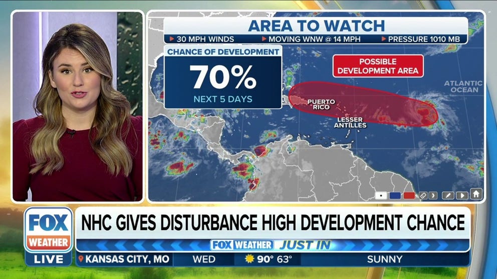
Tropical disturbance in central Atlantic given high chance of development by NHC
The tropical disturbance in the central Atlantic has now been given a high chance of development by the NHC with a 70% chance of development over the next five days.
As is typical for the peak of hurricane season, the FOX Forecast Center is tracking a robust disturbance moving across the central tropical Atlantic that could develop into a tropical depression as it eyes the northeastern Caribbean islands and Puerto Rico late this week.
The tropical disturbance is centered less than 800 miles east of the northeastern Caribbean islands and is producing a large area of showers and thunderstorms. Satellite observations indicate this shower and storm activity is showing signs of organization after finding a pocket of favorable environmental conditions on Wednesday morning.
ATLANTIC HURRICANE SEASON REACHES CLIMATOLOGICAL PEAK SEPT. 10

(FOX Weather)
This disturbance has been dubbed Invest 96L by the National Hurricane Center. An invest is simply a naming convention used by the NHC to identify an area of weather that it is investigating for possible development into a tropical depression or tropical storm within the next five days.
WHAT IS AN INVEST DURING HURRICANE SEASON?
According to the FOX Forecast Center, upper-level winds are not particularly conducive for additional development, but only a slight increase in this disturbance's organization would result in the formation of a tropical depression as it generally moves westward over the central tropical Atlantic during the next day or so.
The NHC currently gives Invest 96L a high chance of development.

(FOX Weather)
The tropical disturbance is expected to move near or over the northeastern Caribbean islands, including the U.S. Virgin Islands and Puerto Rico, on Friday and Friday
night.
"What that means is the northern islands of the Lesser Antilles, (including) Puerto Rico, need to be on alert now because we are expecting to see showers and thunderstorms start to increase in that activity, and we could see some pretty strong wind gusts out of these thunderstorms that are again intensifying in these warmer waters of the Atlantic," FOX Weather meteorologist Jane Minar said.
Recent rainfall has saturated the soils in Puerto Rico, so any additional heavy rain from Invest 96L between Friday and Saturday could lead to flooding in urban areas and small streams, as well as trigger mudslides in the archipelago's mountainous terrain.
WHERE TROPICAL STORMS AND HURRICANES TYPICALLY OCCUR DURING EACH MONTH OF ATLANTIC HURRICANE SEASON
2022 Atlantic hurricane season off to a slow start
Early to mid-September is the time of the season when sea-surface temperatures are the warmest, upper-level winds relax and drier air is typically not widespread.
Unlike recent active years, dry air has been more dominant than usual across the eastern parts of the Atlantic Basin, which has stunted the organization and development of tropical cyclones.
August ended without seeing a single tropical cyclone in the Atlantic Basin for only the second time in the satellite era.
HURRICANE SEASON 2022: AUGUST FINISHES WITHOUT ANY NAMED STORMS FOR FIRST TIME IN DECADES

(FOX Weather)
During an average year, eight named storms and three hurricanes have typically already formed by now, but so far in 2022, the tally stands at only five named storms and two hurricanes.
The next system to organize into a tropical storm with winds of at least 40 mph will be called Fiona.
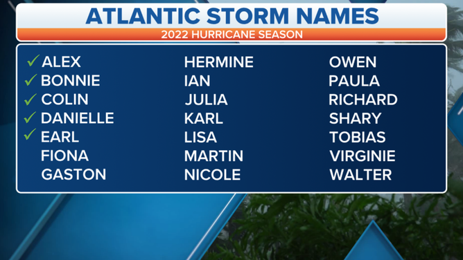
A table showing an alphabetical list of the 2022 Atlantic tropical cyclone names as selected by the World Meteorological Organization. The official Atlantic hurricane season runs from June 1 through Nov. 30.
(FOX Weather)