Tropical Storm Bret to move across Caribbean islands tonight while new depression forms
Residents should be ready for flooding rain up to 6 inches or more, winds gusting to hurricane force in exposed areas, and dangerous conditions on the water and at the coast.
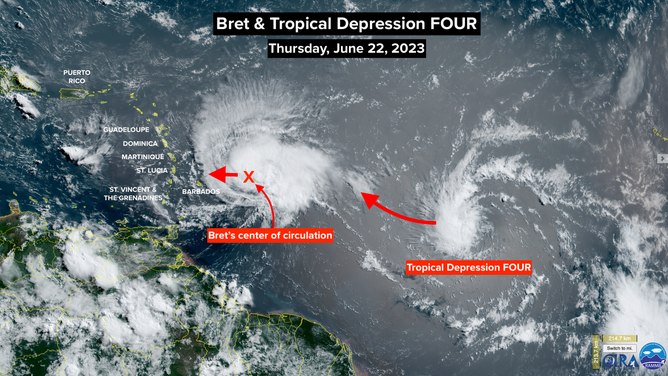
A NOAA satellite image of Tropical Storm Bret and Tropical Depression 4.
(NOAA)
Updated Thursday 10 a.m ET
Tropical Storm Bret intensified to near hurricane strength overnight. It's now on the final approach to the Caribbean. Meanwhile, Tropical Depression Four has formed behind it. It's forecast to soon intensify into Tropical Storm Cindy.
Today is the last chance to prepare in the east-central Caribbean. Tropical Storm Bret is on track to cross the islands, probably near St. Lucia, plus or minus, late this evening or early tomorrow. A Hurricane Watch is in effect there. The islands of Barbados and St. Vincent and the Grenadines to the south are also on alert. Effects will be felt farther north to Guadeloupe, especially in east-facing areas.
The atmospheric environment around Bret is forecast to slowly become more hostile, so little if any strengthening is likely. Although Bret could briefly reach hurricane strength.
Residents should be ready for flooding rain up to 6 inches or more, winds gusting to hurricane force in exposed areas, and dangerous conditions on the water and at the coast.
By tomorrow morning, the weather will be improving in the islands with Bret moving into the central Caribbean Sea.
The upper-level winds will become increasingly hostile, and dry air is forecast to impact the system. As a result, the computer forecasts show Bret dissipating over the weekend. The system's moisture will disperse across the western Caribbean.
Bret poses no significant threat to Puerto Rico or the Virgin Islands and is no issue for the U.S. and surrounding areas.
Behind Bret is the newly designated Tropical Depression Four. The system now has a well-defined circulation, which means it has the mechanical structure to intensify if the atmospheric environment around it is adequate.
The NHC is forecasting the depression to become Tropical Storm Cindy later today or tonight. On average, the fourth named storm of the year comes Aug. 15, so we are in crazy territory here. I know this feels like the third named storm, but there was a later-designated subtropical storm in January that counts as part of this year's list.
Likely Cindy is forecast to turn north before it reaches the Caribbean islands and does not appear to be any threat to land.
Another robust disturbance is just coming off Africa. But this one is farther south, and dry air should help limit its potential. For now, no development is expected.
Disturbances always move off Africa in June, but they usually encounter cool water in the eastern tropical Atlantic. That's why we rarely see development in that part of the ocean until the water temperatures warm up in August. This year's high water temperatures are a key part of what has made this season busy so early.
With the overall weather pattern stuck in place – heat over Texas, strong thunderstorms in Florida and the South, cool in the Northeast, etc. – we'll have to keep an unusually close eye on the tropics.