Tropical moisture fueling renewed flood threat for Helene-ravaged areas of Carolinas
The FOX Forecast Center said rain totals through Saturday will stay between 1–2 inches, but the front will begin to stall, bringing lingering, heavy downpours and 2–3 inches of rain, with higher amounts possible.

Cold front, tropical moisture fueling flood threat in Carolinas
A cold front moving through the Southeast will join tropical moisture to fuel a flood threat this weekend and into next weekend. A PRE could also form into next week, bringing rapid, heavy rainfall to areas already recovering from Hurricane Helene last year.
A cold front moving through the Southeast will join tropical moisture produced by Hurricane Humberto and Invest 94L to fuel a flood threat this weekend for much of North and South Carolina, including areas which were deeply devastated by Hurricane Helene just one year ago.
The front that has been giving parts of the South wet, stormy days is forecast to stall across the Southeast coast, bringing heavy rain to the Carolinas.
Tropical moisture streaming in from Hurricane Humberto off the coast and Invest 94L approaching from the Caribbean will only make the flash flood threat that much worse, the FOX Forecast Center said.
FLOOD WATCH, WARNING AND EMERGENCY: HERE ARE THE DIFFERENCES THAT COULD SAVE YOUR LIFE

(FOX Weather)
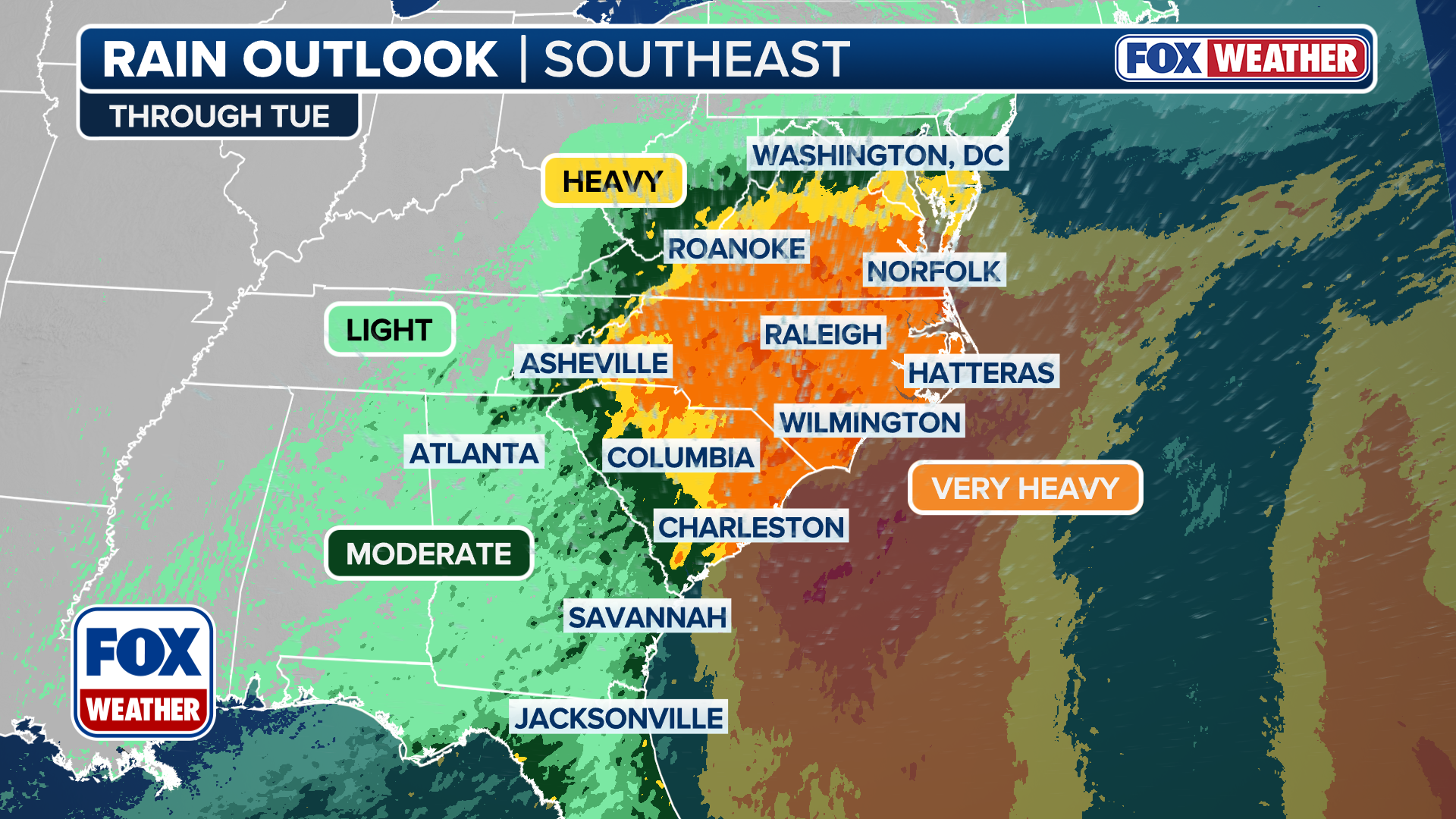
The worst of the rain impacts will stretch from Washington, D.C., into South Carolina.
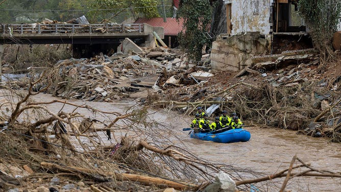
A level 2 of 4 flash flood threat was issued on Friday for much of Western North Carolina, including Asheville, which was badly damaged by flooding during Hurricane Helene one year ago.
Parts of Asheville, and many communities within the Blue Ridge Mountains of Western North Carolina, are still recovering from Helene's aftermath.
HISTORIC BILTMORE VILLAGE SHOWS STRENGTH, RESILIENCE IN RECOVERY 1 YEAR AFTER HURRICANE HELENE
![ASHEVILLE, USA - SEPTEMBER 30: A view of the damaged area at Asheville along with the western part of North-Carolina is devastated by the heavy rains and flooding after Hurricane Helene in Asheville, United States on September 30, 2024 (Photo by Peter Zay/Anadolu via Getty Images)]() Image 1 of 6
Image 1 of 6ASHEVILLE, USA - SEPTEMBER 30: A view of the damaged area at Asheville along with the western part of North-Carolina is devastated by the heavy rains and flooding after Hurricane Helene in Asheville, United States on September 30, 2024 (Photo by Peter Zay/Anadolu via Getty Images) ( )
![A rescue team paddles down the Swannanoa River on Sunday, Sept. 29, 2024.]() Image 2 of 6
Image 2 of 6A rescue team paddles down the Swannanoa River on Sunday, Sept. 29, 2024. (Travis Long/The News & Observer/Tribune News Service)
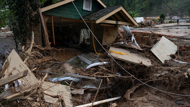
![The remnants of a home are seen in Lake Lure, North Carolina, October 2, 2024, after the passage of Hurricane Helene. The death toll from powerful storm Helene, which battered the southeastern United States, has climbed to more than 155, authorities said on October 1, as President Joe Biden and Vice President Kamala Harris surveyed the damage. (Photo by Allison Joyce / AFP) (Photo by ALLISON JOYCE/AFP via Getty Images)]() Image 3 of 6
Image 3 of 6The remnants of a home are seen in Lake Lure, North Carolina, October 2, 2024, after the passage of Hurricane Helene. The death toll from powerful storm Helene, which battered the southeastern United States, has climbed to more than 155, authorities said on October 1, as President Joe Biden and Vice President Kamala Harris surveyed the damage. (Photo by Allison Joyce / AFP) (Photo by ALLISON JOYCE/AFP via Getty Images) ( )
![Workers, community members, and business owners clean up debris in the aftermath of Hurricane Helene in Marshall, North Carolina on Monday, Sept. 30, 2024.]() Image 4 of 6
Image 4 of 6Workers, community members, and business owners clean up debris in the aftermath of Hurricane Helene in Marshall, North Carolina on Monday, Sept. 30, 2024. (Jabin Botsford/The Washington Post via Getty Images)
![]() Image 5 of 6
Image 5 of 6Avery county, NC family escapes devastating mudslide (Alisha and Matthan Hicks)
![The remnants of a home are seen in Lake Lure, North Carolina, October 2, 2024, after the passage of Hurricane Helene.]() Image 6 of 6
Image 6 of 6The remnants of a home are seen in Lake Lure, North Carolina, October 2, 2024, after the passage of Hurricane Helene. (ALLISON JOYCE/AFP via Getty Images)


The FOX Forecast Center said rain totals through Saturday will stay between 1–2 inches, but the front will begin to stall, bringing lingering, heavy downpours and 2–3 inches of rain, with higher amounts possible.
The greater concern comes from what could happen leading into next week.
"Every day next week there's a chance of showers and storms," FOX Weather Meteorologist Stephen Morgan said on Friday. "We're not talking these afternoon downpours. It could be some organized rain that could be concerning."
(FOX Weather)
As Invest 94L and Hurricane Humberto move through the Atlantic and near the U.S. East Coast, tropical moisture will surge into the southeast.
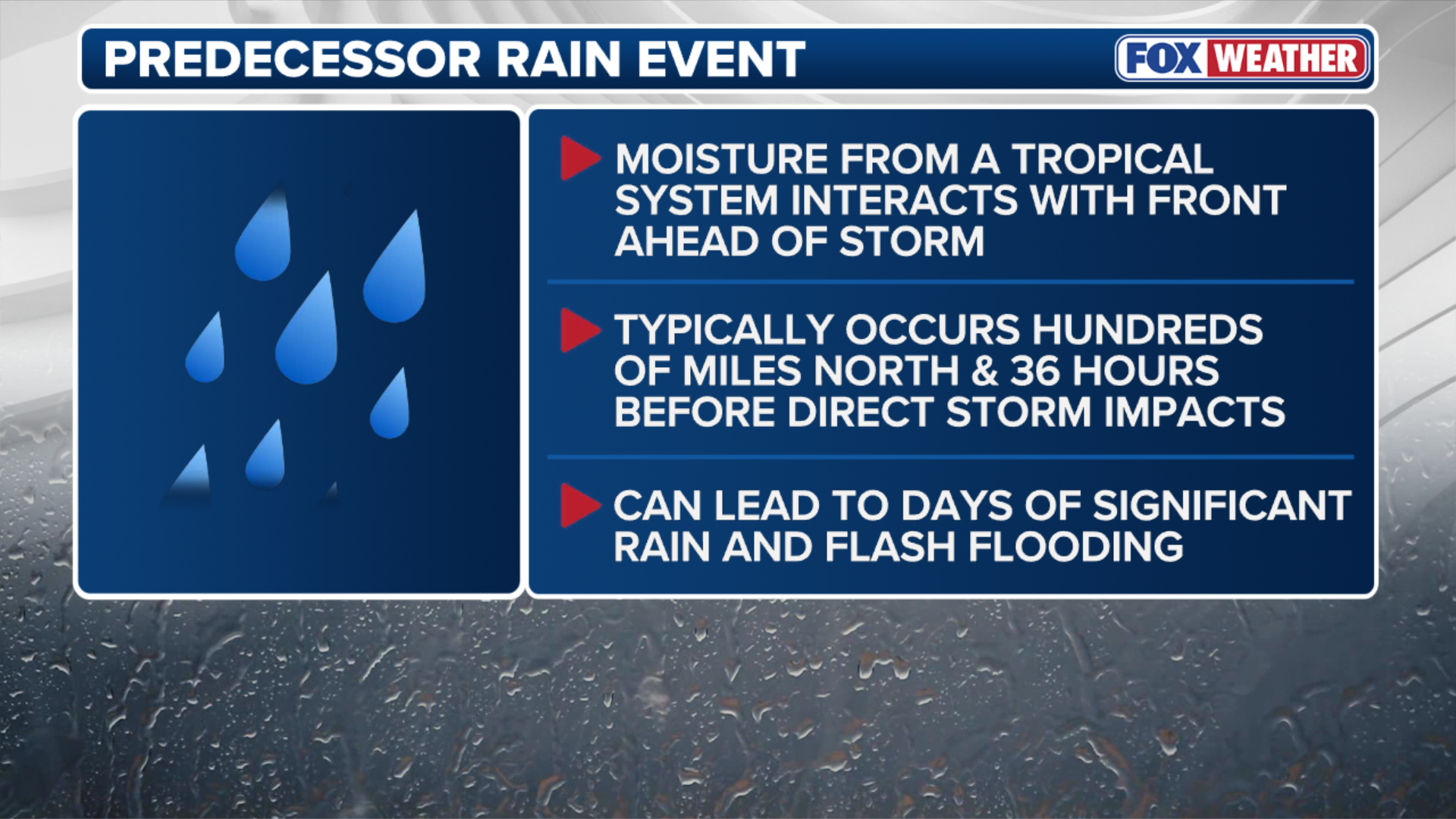
With this type of setup, a predecessor rain event (PRE) could develop before any tropical system moves closer to the region. This is the same type of event that did most of the flooding during Hurricane Helene last year, the FOX Forecast Center said.

Hurricane Specialist Bryan Norcross provides exclusive analysis on future of Invest 94L
FOX Weather Hurricane Specialist Bryan Norcross joins us to give his exclusive analysis on the state of the tropics, including Invest 94L, Hurricane Humberto and possible impacts to the Carolinas.
"It occurs hundreds of miles north of where a tropical system is," Morgan said.
(FOX Weather)
While it's too early to tell exactly where Invest 94L will end up, it's forecast that Hurricane Humberto will remain off the coast of the U.S., therefore avoiding any direct landfall threats.
The Hurricane Hunters will fly into Invest 94L on Friday afternoon to get a better idea of the track this system could take.