Tropical development possible in three areas of the Atlantic Basin this week
Parts of the U.S. Gulf Coast should pay close attention to the forecast
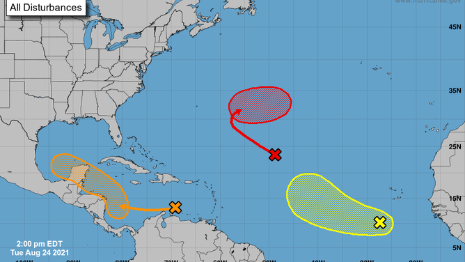
The tropical weather outlook issued at 2 p.m. Eastern on Aug. 24, 2021.
(NOAA/NHC)
Three areas are being monitored for possible tropical development in the Atlantic Ocean and Caribbean Sea as we approach the Sept. 10 peak of hurricane season.
We'll discuss the forecast for each one, including any potential impacts to the United States.
Disturbance No. 1: Medium chance of development
While nothing is imminent, the NHC expects a broad area of low pressure to form over the southwestern Caribbean Sea later in the week from a tropical disturbance currently located over the central Caribbean (the "X" on the left of the map above).
Environmental conditions are favorable for development in this area, so there's a medium chance that a tropical depression could form late this week or this weekend as the system moves northwestward, according to the NHC.
This potential system will likely track over the northwestern Caribbean Sea, across Mexico's Yucatan Peninsula, and then into the southwestern Gulf of Mexico by Sunday.
From there, the forecast gets a bit more uncertain. Some computer forecast model guidance suggests the system will head in the direction of southern or southeastern Texas, while other models have a more southern solution into northern Mexico.
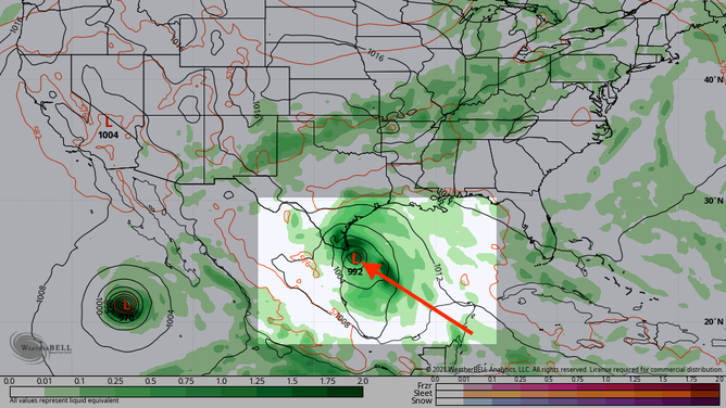
GFS model showing a possible tropical system in the Gulf of Mexico next Monday.
(WeatherBELL)
Disturbance No. 2: High chance of development
The second disturbance, dubbed Invest 97L by the National Hurricane Center, is located over the central tropical Atlantic Ocean about 1,000 miles east-northeast of the northern Leeward Islands (the "X" in the middle of the map at the top of this story).
An invest is a naming convention used by the NHC to identify areas it is investigating for possible development into a tropical depression or tropical storm within the next five days.
Environmental conditions will be unfavorable for tropical development over the next couple of days. However, conditions are expected to become more favorable later this week.
The NHC said there's a medium chance that a tropical depression could develop by the end of the week as the system turns eastward over the central Atlantic. It is not currently expected to affect any land areas.
Disturbance No. 3: Low chance of development
The NHC is monitoring another tropical disturbance, dubbed Invest 98L, over the eastern tropical Atlantic Ocean a few hundred miles south-southwest of the Cabo Verde Islands (the "X" on the right of the map at the top of this story). It's currently producing a concentrated area of showers and thunderstorms.
Some development is possible over the next several days as the system moves westward over the eastern tropical Atlantic. However, upper-level winds are predicted to become less favorable for development by the weekend, so the NHC only gives it a low chance of formation.
This system is not currently expected to affect any land areas.
Check back to FOX Weather for updates on all three systems in the days ahead.