Tracking the tropics: Northern Hemisphere finally sees its first tropical depression
PAGASA names tropical depressions, tropical storms and typhoons. The latest date on record for seeing the western Pacific’s first cyclone is June 8, which happened in 1983. Despite the slow start in 1983, 23 cyclones formed, with ten that became typhoons.

FOX Weather Hurricane Specialist Bryan Norcross analyzes hurricane season forecast
NOAA has released its hurricane season outlook plus a look at what is spinning in the tropics right now.
Days before the start of the Atlantic basin hurricane season, the Northern Hemisphere is showing signs of activity, with the first tropical cyclone of the year forming near the Philippines.
The Philippine Atmospheric, Geophysical and Astronomical Services Administration (PAGASA) was tracking Tropical Depression Aghon, which was expected to strengthen into a tropical storm.
Unlike the Atlantic basin, where there are start and end dates for the season, the western Pacific can produce cyclones year-round, but the bulk of activity happens from May through October.
The development of Aghon was unusually late in the year and solidifies 2024 as being the fifth-slowest start to tropical cyclone activity in the basin.
The latest date on record for seeing the basin’s first cyclone is June 8, which happened in 1983.
NOAA ISSUES ITS MOST AGGRESSIVE HURRICANE SEASON FORECAST ON RECORD
During an average season, 26 storms form, with 16 that strengthen into typhoons, but these values have not been reached since 2019.
Typhoons are much like what hurricanes are called in the Atlantic basin and have sustained winds of at least 74 mph.
The tropical depression is forecast to turn sharply northward and could strengthen into a tropical storm while north of the Philippines.
The main threat to the islands that make up the country in Southeast Asia is heavy rainfall as sustained winds remain below 40 mph.
During the next week, a combination of westerly winds and steering flow toward the north and northeast will help weaken the cyclone and prevent it from threatening significant population centers in Taiwan and Japan.
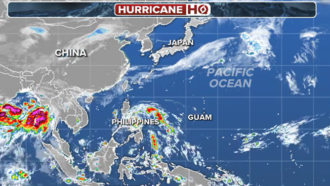
Tracking the tropics: Western Pacific Ocean satellite
(FOX Weather)
2024 ATLANTIC HURRICANE SEASON GUIDE: HERE’S WHAT TO KNOW ABOUT THIS YEAR’S STORMS
Pacific Ocean monitored by several meteorological organizations
Due to several agencies having jurisdiction over the largest ocean on the planet, cyclone naming is a bit complex.
If the system forms in the southwest part of the basin, such as what happened with Aghon, PAGASA is responsible for forecasts, but systems are also tracked by the United States Joint Typhoon Warning Center.
If a cyclone forms in the northwest part of the basin, Japan’s meteorological organization will use an entirely different list of names.
Another major difference between the meteorological agencies is that the national weather service of the Philippines names tropical depressions, while others assign weak systems numbers or letters until they reach the tropical storm threshold.
The first name on the World Meteorological Organization’s 2024 list for cyclones in the western Pacific is Ewiniar – a name that the tropical depression Aghon could be known by once it gains winds of at least 40 mph.
The cyclone is the only feature being tracked in the western Pacific in what will likely be another down year for activity in the basin as an El Niño transitions into a La Niña by the fall.

Expected track of Aghon
(FOX Weather)