Unusual June tropical disturbance speeding across southern Caribbean while Gulf system tries to organize
Three areas of troubled weather are being tracked across the North Atlantic basin
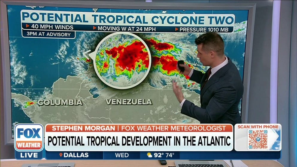
Potential Tropical Cyclone Two nearing ABC Islands
As of 2 p.m. Eastern, the storm system had winds of 40 mph with higher gusts. It was located about 85 miles southeast of Curaçao and was speeding off to the west at 24 mph.
Tropical Disturbance No. 1, which we have followed across the tropical Atlantic, has now entered the Caribbean. It is flying toward the west, just north of the Venezuelan coast, and will move through the ABC islands Wednesday, first coming across Bonaire, then Curaçao, and finally Aruba.
The National Hurricane Center is designating this system Potential Tropical Cyclone 2 as part of their protocol for issuing tropical storm warnings for the islands. Winds of 40 mph have been measured in the storm, so they are ready to name it Bonnie if it ever fully organizes. Even with the fancy name, however, it is still just a tropical disturbance.
HOW TO WATCH FOX WEATHER ON YOUR TV
This is quite unusual for June. Only once before in the record book, in 1933, has a tropical system come near these islands this early in the season. Technically, of course, this one won’t count in the future, unless it is able to organize enough to officially become Tropical Storm Bonnie. But the records are still indicative of how unusual it is to have any tropical system track this far south.

(FOX Weather)
The disturbance still has a slight chance of becoming Tropical Storm Bonnie on Wednesday. The atmospheric conditions are supportive. But systems that are moving super quickly have a harder time acquiring a full circulation. Since the whole system is zooming to the west at about 30 mph, the winds on the bottom side of the attempted circulation would have to be stronger than that to get going.
BONNIE LIKELY TO FORM AS SYSTEM CONTINUES TO MOVE RAPIDLY ACROSS SOUTHERN CARIBBEAN

(FOX Weather)
Imagine a system that is standing still and has a donut of 40 mph winds circulating counterclockwise around the center. Now, move the system to the west at 25 mph. Winds at the top of the donut get accentuated (40 + 25 = 65 mph) because they are going in the same direction as the movement. But on the bottom side, the winds get canceled down to a net of 15 mph. Since this speedy system isn’t very strong, getting bottom-side winds going has been a challenge.
On the projected track, the northern coastlines of Venezuela and Colombia are just ahead. Even though the disturbance should slow down a bit as the steering flow weakens, dry air feeding into the system off the land will likely limit significant development. Although, if it tracks just far enough offshore, and slows down sufficiently, Bonnie could still form.
WHAT IS A POTENTIAL TROPICAL CYCLONE?

(FOX Weather)
Once the system clears the South American landmass late tomorrow or early Friday, development appears likely over the extreme southwestern Caribbean. This means that southern Nicaragua is projected to be impacted by a stronger system.
Interestingly, what should be Bonnie by then is forecast to move across the thinnest part of Central America and emerge into the Pacific, though as a weaker system. Assuming it acquires a circulation over the Caribbean and maintains it across the landmass, it would still be called Bonnie if it redevelops over the Pacific Ocean.
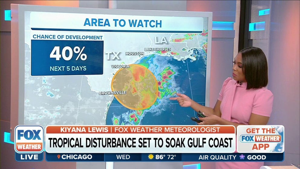
Gulf disturbance
In the Gulf, there is a broad area of low pressure off the coast of southern Texas, which is drifting toward shore. I’m labeling it Disturbance No. 2. Heavy thunderstorms are associated with the system, but they are not organized around the circulation. There is a decent chance that the disturbance will organize enough to be designated a tropical depression before it comes ashore about Friday.
TRACKING THE TROPICS: WHAT A TROPICAL DISTURBANCE IN THE GULF MEANS FOR TEXAS

(FOX Weather)
Whether it organizes or not, the main threat with this system is the heavy rain it will drag over the Texas coast tomorrow and Friday. This system combined with an old front will keep rain going over the rest of the northern Gulf coast through the weekend.
Coastal Texas is having a drought, so the rain will be beneficial if it doesn’t come too fast.
Gulf Coast to get hit with heavy rain from tropical disturbance
The rain will begin to increase along the immediate Texas and Louisiana coast on Wednesday and then push inland on Thursday.
Third disturbance
Out in the Atlantic, Tropical Disturbance No. 3 is just a blob of moisture. It is projected to reach the Caribbean islands late Friday into the weekend. Its odds of development are fairly low, but in any case, it will likely bring gusty tropical rainstorms to the islands.
This disturbance will likely take a more northerly track than its better-developed cousin Tropical Disturbance No. 1. This means that the northeastern Caribbean islands including Puerto Rico and the Virgin Islands will likely be affected.
HOW TO PREPARE FOR HURRICANE SEASON
Stay informed on the potentially affected islands to be sure the system doesn’t quickly organize into something more threatening.
Hopefully, Mother Nature with take its typical late June/early July break after this. But we’ll see. Nothing obvious is on the horizon.
GET THE LATEST EPISODE OF THE TRACKING THE TROPICS PODCAST
Be sure to download the FOX Weather app to track any storms in your area and receive potentially life-saving weather alerts issued by the National Weather Service. The free FOX Weather livestream is also available 24/7 on the website and app and on your favorite streaming platform. The FOX Weather Update podcast also provides weather information for the entire country.