Northeast weather system to bring snow, but will major cities along I-95 be shoveling?
Washington has a snowfall deficit of more than 17 inches. Boston is more than 30 inches in the hole, and New York is around 2 feet below average.
Parts of the Northeast, I-95 corridor could see snow this weekend
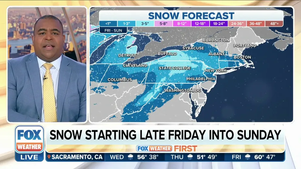
The FOX Forecast Center is tracking the potential for snow in the Northeast this weekend. Forecast models suggest around that a couple inches of snow could fall late Friday into Sunday. This includes New York City, Boston, and D.C.
NEW YORK – The FOX Forecast Center is tracking the potential for snow in the Northeast this weekend, but much like every other winter storm this season, the system will fail to amount to much in the major cities along Interstate 95.
As has been the case for most of the winter, moisture and cold air have not been in sync – meaning that when precipitation has fallen, it has mostly done so in the form of rain because air temperatures are simply too warm.
The storm system will approach the region on Friday and exit by Sunday morning. The FOX Forecast Center will be paying a close eye to about a 36-hour period when there could be enough cold air intrusion to make flakes fly in some of the major cities in the Northeast.
How much snow will fall?
Areas of the interior Northeast are forecast to pick up the most snow, with the potential for 3 to 5 inches from Rochester in New York to State College in Pennsylvania.
‘QUITE CATASTROPHIC’: CALIFORNIA MOUNTAIN RESIDENTS PLEAD FOR MORE HELP AS FEET OF SNOW REMAIN

(FOX Weather)
Will the I-95 corridor get any snow?
Areas to the south and east, closer to the Northeast and mid-Atlantic coasts, are slated to see substantially less snow.
The heaviest snowfall event to impact New York City so far this season happened in late February when 1.8 inches fell over Central Park. The lack of snow has caused the city's overall snowfall deficit to balloon to around 2 feet, and it remains a question whether the weekend system will muster up enough cold air and frozen precipitation to even beat February’s minuscule amounts.
HAVE AND HAVE-NOTS: SEE HOW MUCH SNOW FELL AND WHERE THIS WINTER
![]() Image 1 of 4
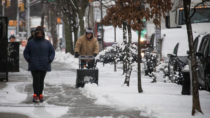
Image 1 of 4A resident clears snow from a sidewalk following a storm in the Brooklyn borough of New York, US, on Tuesday, Feb. 28, 2023. (Michael Nagle/Bloomberg)
![]() Image 2 of 4
Image 2 of 4A dog is taken for a walk through Riverside Park on the West Side of New York City on February 28, 2023, as the city records its first significant snowfall in over a year. (TIMOTHY A. CLARY/AFP)
![]() Image 3 of 4
Image 3 of 4A view of city during a foggy day after its biggest snowfall of this season the late in New York, United States on February 28, 2023. (Selcuk Acar/Anadolu Agency)
![]() Image 4 of 4
Image 4 of 4People walk by the Bethesda Fountain in Central Park after a snowfall on February 28, 2023, in New York City. (Gary Hershorn)


Chances of measurable snowfall (at least 0.1 inches) from the upcoming event decrease even further as you head south along I-95 toward the nation's capital.
Baltimore and Washington, who are dealing with snowfall deficits of around 17 inches, are not currently expected to pick up any snowfall from the weekend storm system. Computer forecast models show air temperatures will likely be too warm for snow, with low temperatures only dipping into the mid- to upper 30s.

(FOX Weather)
What are the expected impacts of this weekend's snow?
As long as snowfall amounts remain light in Boston and New York, the winter wonderland will be primarily an inconvenience for travelers and will spare communities from significant disruptions.
"If you do live closer to New York or Philadelphia, it's going to be right on that cusp of maybe seeing an inch or maybe not," FOX Weather meteorologist Marissa Torres said. "It’s a big asterisk here because we're still fine-tuning the totals."
WHEN CAN YOU EXPECT THE LAST SNOW OF THE SEASON?
NOAA expects a colder pattern to develop for a large part of the East in March, which could be a solution for winter weather lovers if there is enough precipitation to take advantage of the colder air.
But if March ends on a relatively snowless note, the chances for measurable snow decrease tremendously during April as average high temperatures reach the 50s and 60s across most of the northern tier of the country.

(FOX Weather)