Severe Thunderstorm Watch issued for threats of large hail, damaging winds in Great Lakes region
The storms will be widely scattered, but damaging winds will be the main hazard with this activity
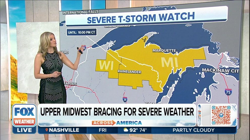
Severe Thunderstorm Watch issued for parts of Wisconsin and Michigan
Severe Thunderstorm Watch issued for parts of Wisconsin and Michigan until 10 p.m. central time on Thursday.
A cold front moving through the central part of the country could help to trigger showers and thunderstorms on Thursday from eastern Colorado into the Great Lakes.
A widespread severe weather outbreak is not anticipated, but meteorologists warn some storms will be capable of producing damaging winds and hail.
Cities in the threat zone include Omaha, Nebraska; Des Moines, Iowa; Minneapolis/St. Paul; and Green Bay, Wisconsin.
Happening Now
A Severe Thunderstorm Watch has been issued for parts of northern Wisconsin and the Upper Peninsula of Michigan through 10 p.m. CDT.

(SOURCE GOES HERE IN PARANTHESES)
Meteorologists warn some storms could produce large hail upwards of two inches in diameter and scattered damaging winds to 70 mph.
HOW TO WATCH FOX WEATHER ON TV

(FOX Weather)
Most of the thunderstorms will occur during the afternoon and evening hours, but because meteorologists do not expect the storms to stall over the same areas, widespread flooding concerns will be minimal.
The cold front will continue eastward on Friday, with the chance of showers and thunderstorms extending from the interior Northeast into the upper Ohio Valley.
Forecast models show most of the activity will be scattered, and the atmosphere will lack the ingredients for any type of widespread severe weather outbreak.

(FOX Weather)
Meteorologists say any time a thunderstorm develops during the summer, it has the chance of becoming strong to severe, so it is always beneficial to keep updated with the latest forecast.
WHY IT RAINED WHEN YOUR WEATHER APP SAID THERE WAS ONLY A 20% CHANCE OF PRECIPITATION
The same frontal boundary could linger over the Northeast during the Independence Day holiday weekend and provide plenty of chances for scattered showers and storms.
Most of the rain is forecast to move out of the region for Monday’s holiday celebrations.
FIRST LOOK: INDEPENDENCE DAY WEEKEND FORECAST

(FOX Weather)
GET THE LATEST EPISODE OF THE FOX WEATHER UPDATE PODCAST
Be sure to download the FOX Weather app to track any storms in your area and receive potentially life-saving weather alerts issued by the National Weather Service. The free FOX Weather livestream is also available 24/7 on the website and app and on your favorite streaming platform. The FOX Weather Update podcast also provides weather information for the entire country.