Northern Rockies, Plains gear up for first major snowstorm of season
Computer forecast models indicate the ingredients may be coming together for heavy snow to fall from the Rockies to the Plains, according to the FOX Forecast Center.
Pacific storm could deliver up to 1 foot of snow across Rockies
The first major snow of the season for the Northern Rockies and Northern Plains could deliver up to a foot of snow in the mountains by mid week in Montana, Wyoming and the Dakotas. For the main mountain passes in the Pacific Northwest between 5 and 10 inches is possible.
Portions of the northern Rockies and northern Plains are expected to receive their first major snow of the season this week.
Computer forecast models indicate the ingredients may be coming together for heavy snow to fall from the Rockies to the Plains, according to the FOX Forecast Center.
But first, an initial storm system will affect the region through Monday, bringing rain and high-elevation snow to the Northwest and northern Rockies.
"We have this appetizer setting the stage this weekend," FOX Weather meteorologist Jane Minar said. "A bigger storm arrives as we go into the middle of (this) week."
A parade of lows is responsible for the surge of moisture across the Northwest. As one moves across the Rockies on Monday, another is set up just behind it.
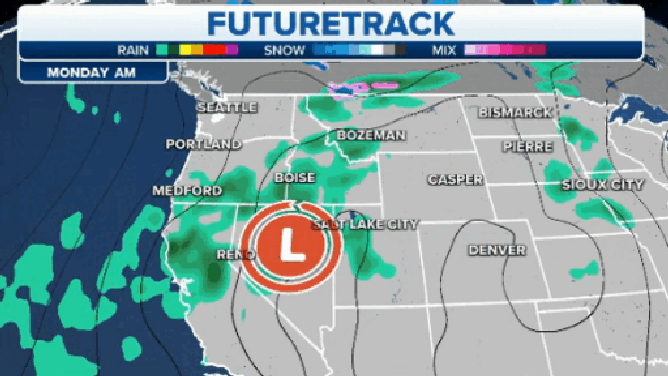
A series of lows will track across the Northwest, bringing snow and rain.
(FOX Weather)
WHEN CAN YOU EXPECT THE FIRST SNOW OF THE SEASON?
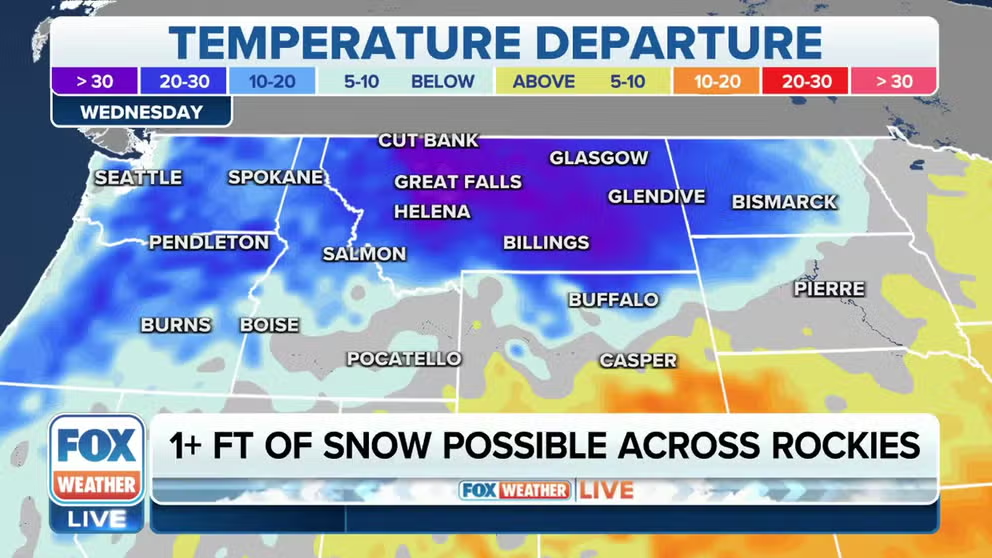
By midweek, a more potent storm is forecast to dive south out of Alberta, Canada. That storm may drag down some of the coldest air the region has felt so far this season.
Temperatures across the West will reflect the major chill, with highs in the 20s and 30s on Wednesday for places like Billings, Montana.
With ample moisture in place, the colder temperatures will mean increasing chances for widespread snow, even at lower elevations.
"We're not talking about just like a dusting," FOX Weather Meteorologist Michael Estime said. "We're talking like 6 to 12 inches of snow. In northwest parts of Wyoming, we could be talking about over a foot of snow."

(FOX Weather)
While snow is forecast across higher elevations and mountain passes, between a half-inch and 1 inch of rain will fall from Eugene, Oregon, into Boise, Idaho, through this week.
HOW COLD DOES IT HAVE TO BE TO SNOW?

(FOX Weather)
At this point, the FOX Forecast Center said it's too early to determine exactly where and how much snow will fall, but more than a foot of snow appears likely at higher elevations of Montana. This is quite a contrast from last week when the region was experiencing record-high temperatures in the upper 70s and lower 80s.
Snow forecast across high-traffic mountain passes
Some of the higher snow totals may even make their way down to lower elevations, impacting road travel in the region.

(FOX Weather)
FOX 13 Seattle Meteorologist Abby Acone said the first round of mountain snow could be a "decent dumping" for the passes over the Cascade Range, which could create travel woes.
"That's kind of tricky when we're talking about the first round of winter white for the mountain passes," Acone said. "For folks who don't know, the Cascade Mountain Range is so important for us here in Washington and Oregon. And it helps people move from east to west across both sides of the states."
Between 5 and 10 inches of snow is forecast for the main mountain passes, including Snoqualmie Pass on Interstate 90 in Washington.
There are indications that this storm will then roll east and northeast, spreading snow over the Dakotas, too. This could lead to significant impacts on east-west interstates through late week.