Severe Thunderstorm Watches in effect for 21 million Americans from New England to mid-Atlantic
Storms will be capable of producing damaging wind gusts and will have plenty of lightning
Severe Thunderstorm Watch issued for a large part of New England, Northeast
More than 13 million Americans from Maine to New York are under a Severe Thunderstorm Watch until 8 p.m. Eastern.
A front moving through the eastern third of the nation will be the focal point for showers and thunderstorms on Thursday from New England to the Gulf Coast.
Meteorologists will be watching for the threat of damaging winds, heavy rainfall and lightning from the storms.
Afternoon storms turned deadly in Georgia on Wednesday when lightning struck a US Army Base. At least one soldier was killed, and nine others were injured when a line of showers and thunderstorms traveled through the Peach State.
The Storm Prediction Center says it expects damaging wind gusts to be the main threat on Thursday but cannot entirely rule out hail or an isolated tornado.
Severe thunderstorm watch
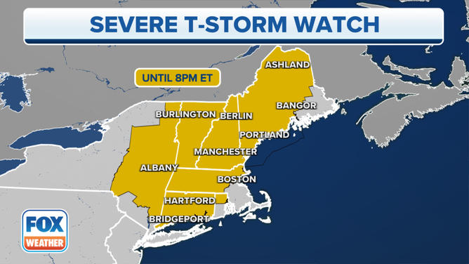
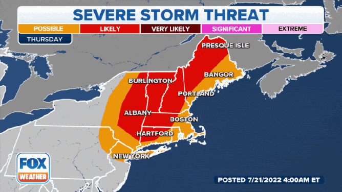
A Severe Thunderstorm Watch is in effect until 8 p.m. for parts of Maine, New Hampshire, Vermont, New York, Massachusetts, Rhode Island and Connecticut.
(FOX Weather)
Because of the threat of severe weather on Thursday, a Severe Thunderstorm Watch has been issued until 8 p.m. Eastern for more than 13 million Americans in Maine, New Hampshire, Vermont, New York, Massachusetts, Rhode Island and Connecticut.

(FOX Weather)
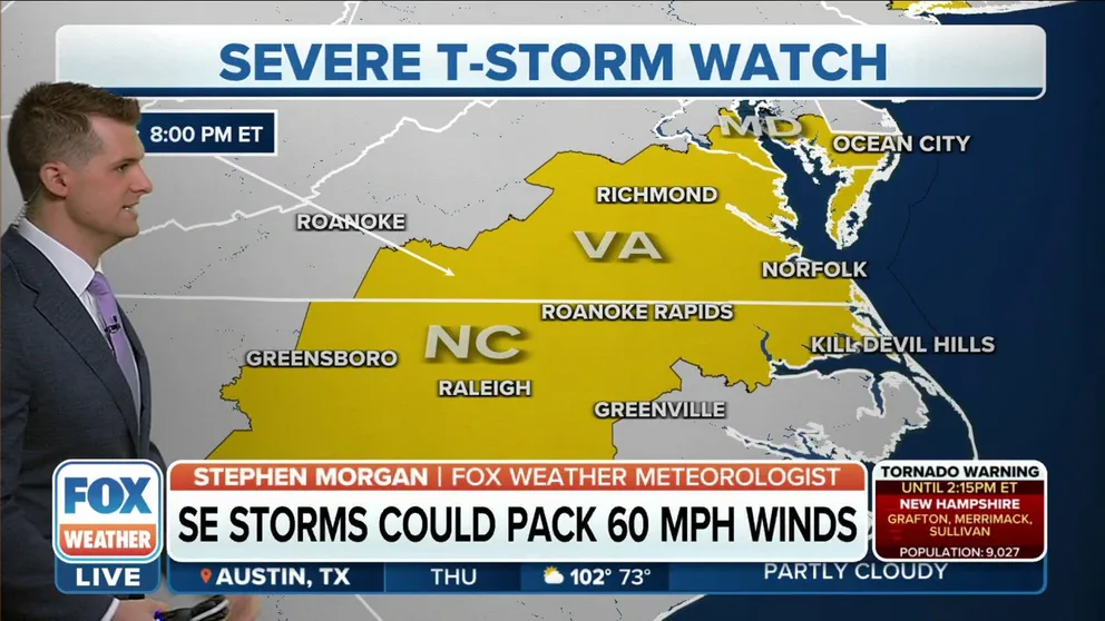
An additional 8 million people are under a Severe Thunderstorm Watch from Maryland to North Carolina until 8 p.m. Eastern.
The main threats will be damaging winds, large hail and frequent lightning.
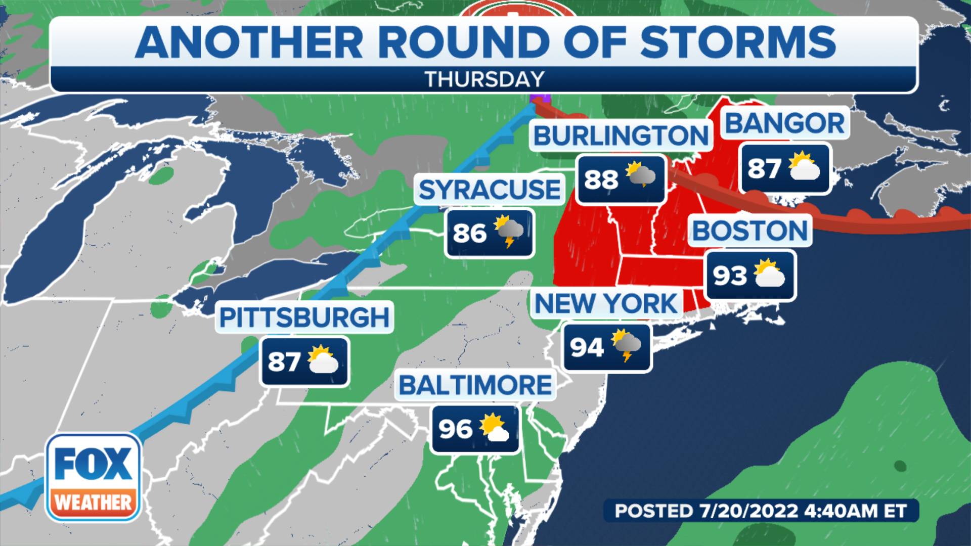
Northeast Forecast
The combination of the storm system and plenty of warm, moist air could help initiate showers and thunderstorms as early as late morning.
Cities under the most significant threat of storms include: Albany, New York; Burlington, Vermont; and Boston.
"We are tracking the potential for some wind shear — that is a change of wind direction and speed with height," says FOX Weather meteorologist Jason Frazer. "And that tends to lead to some of these (severe) thunderstorms developing."
Forecast models show the rain could be heaviest in interior New England, where a quick inch or two could fall in the heavier storms.
(FOX Weather)
"Thunderstorms are going to continue to flourish as we move throughout the afternoon time as that cold front slowly moves eastward," Frazer said. "By 5 o’clock, it’ll be those of you not only in the Portland area but those of you to the west of Bangor that will likely see some of those heavy downpours."
Once the front pushes offshore, it should end the chance of rain.
FLORIDA WOMAN CAPTURES STUNNING ‘RAINBOW LIGHTNING’ PHOTO
Southeast Forecast
Millions under Severe Thunderstorm Watch from Maryland to North Carolina
A Severe Thunderstorm Watch is in effect until 8 p.m. Eastern in the mid-Atlantic.
Widespread thunderstorms are expected to develop by late afternoon and last into the evening.
Any thunderstorm during the summer has the chance of turning severe, but the best chance of finding a strong storm will be south of Interstate 40.
Cities under the most significant threat of storms include: Jackson, Mississippi; Birmingham, Alabama; Atlanta; Charlotte; and Raleigh.
Similar to the Northeast, damaging wind gusts will be the main threat.
Forecast models show the front will stall over the region, which means there will likely be several days of wet weather.
