Ferocious storms blast Iowa, Nebraska regions still reeling from major tornadoes earlier in the month
Towns in the Plains still in the infant stages of recovery from deadly tornadoes that raced through on Tuesday were faced with another round of blistering severe weather Thursday night and Friday morning.

Severe Thunderstorm Watch issued for parts of Illinois, Missouri and Iowa
A Severe Thunderstorm Watch has been issued for the St. Louis metro until at least 9 p.m. local time due to the threats of hail and damaging winds.
DES MOINES, Iowa — Towns in the Plains still in the infant stages of recovery from deadly tornadoes that raced through on Tuesday were faced with another round of blistering severe weather Thursday night and Friday morning.
Supercell thunderstorms that began in western Nebraska on Thursday afternoon with scattered reports of tornadoes and baseball-sized hail later congealed into a squall line Thursday night that brought widespread reports of 70 mph wind gusts or greater as it swept through eastern Nebraska into Iowa on Friday morning.
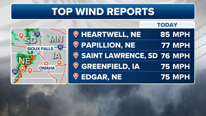
The town of Greenfield, Iowa, which was heavily damaged by an EF-4 tornado Tuesday, reported gusts of 70-75 mph early Friday morning as the storms rolled through. Heartwell, Nebraska hit a gust of 85 mph while Papillion, Nebraska reported a gust of 77 mph and Missouri Valley, Iowa hit 74 mph.
The squall line moved through Des Moines around 5 a.m. CT with continued Severe Thunderstorms and Tornado Warnings. Des Moines Police reported multiple downed trees and limbs in the city, with some power outages. Madison County Emergency managers echoed those reports with "multiple calls of storm damage and power outages around the county."
National Weather Service spotters reported a tree fell on a home in Pershing, Iowa, while a tree fell onto a car in St. Charles, Iowa and semi trucks were blown over on Iowa's Interstate 35 near Ellsworth and Highway 20 in Buckeye.
"Debris is also scattered across the road from a farm that took a hit from the storm," Iowa State Patrol Trooper Paul Gardner posted on X from the Interstate 35 closure.

Southbound lanes of Interstate 35 are CLOSED in Hamilton County north of Ellsworth due to semis blown over and power lines down.
(Trooper Paul Gardner / Iowa State Patrol / FOX Weather)
About 60,000 people had lost power in Nebraska and Iowa at the peak of the storms Friday morning, according to PowerOutage.US, but those numbers have been dwindling Friday as the storms cleared the area.
The threat of storms will not end on Friday, as renewed rounds of wet weather are expected to continue into the holiday weekend.
MILLIONS FACE THREAT OF TORNADOES, LARGE HAIL, DAMAGING WINDS THROUGH MEMORIAL DAY WEEKEND
Massive hail reported in Oklahoma Thursday
Clusters of supercell thunderstorms first brought reports of large hail and some tornadoes to western Nebraska and Oklahoma Thursday afternoon.
One of the tornadoes impacted Jackson County, Oklahoma around the town of Olustee, where power was reported to be out. In addition to tornadoes, hail upwards of softball-size was reported in Nebraska.

Multi-vortex tornado spotted in southwest Oklahoma
A multi-vortex tornado spotted in southwest Oklahoma on Thursday by FOX Weather exclusive storm tracker Corey Gerken
Hail was also fairly common in southwest Oklahoma, where it fell about the size of baseballs, south of Interstate 40, on Thursday evening.

Baseball-sized hail north of Hollis, Oklahoma on May 23, 2024
(@CoreyGerkenWX / FOX Weather)