Tornado Watch issued as severe storms threaten the South through Wednesday night
A more significant severe weather threat is predicted to materialize New Year's Eve into New Year's Day
Tornado watch in effect for several Southeast states
Arkansas, Louisiana, Mississippi and Tennessee now under a tornado watch.
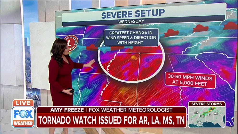
Severe thunderstorms, including the threat of tornadoes, have returned to the South on Wednesday with a stalled cold front draped across the region.
NOAA's Storm Prediction Center has issued a Tornado Watch valid until 7 p.m. Central time for southeastern Arkansas, northeastern Louisiana, northern Mississippi and southwestern Tennessee.
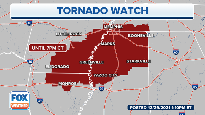
A Tornado Watch is in effect for parts of the South until 7 p.m. Central time.
(FOX Weather)
The storms are predicted to continue through Wednesday night from parts of the lower Mississippi Valley into the Tennessee Valley and southern Appalachians.
WHAT YOU SHOULD DO TO PREPARE FOR TORNADOES
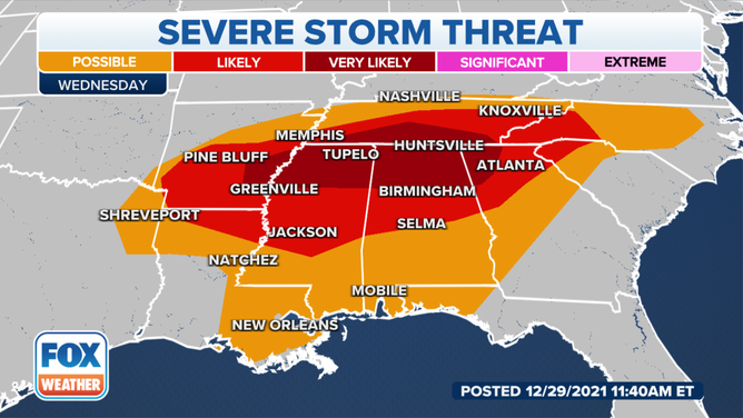
Severe thunderstorm threat on Wednesday, Dec. 29, 2021.
(FOX Weather)
The greatest risk for tornadoes is in east-central Arkansas, northern Mississippi, northern Alabama, southern Tennessee and northwestern Georgia. Some of the twisters have the potential to be strong, especially from northern Mississippi into northwestern Alabama.
Damaging wind gusts and large hail are also expected with these severe storms across the South through Wednesday night.
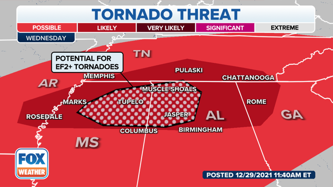
Tornado threat on Wednesday, Dec. 29, 2021.
(FOX Weather)
High rainfall rates up to 1.5 to 2 inches per hour could also trigger flash flooding in parts of the Tennessee Valley and southern Appalachians on Wednesday.
Areas from northern Mississippi and northern Alabama into northern Georgia and much of Tennessee have the greatest risk of flash flooding through Wednesday night.
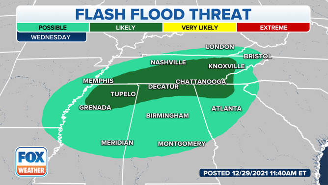
Flash flood threat on Wednesday, Dec. 29, 2021.
(FOX Weather)
EXPLAINING FLOOD ALERTS ISSUED BY THE NATIONAL WEATHER SERVICE
On Thursday, a few strong to isolated severe thunderstorms are possible across portions of the Southeast into the Carolinas.
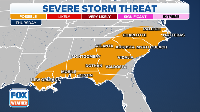
Severe thunderstorm threat on Thursday, Dec. 30, 2021.
(FOX Weather)
A more significant severe weather threat is predicted to materialize across the South on New Year's Eve, likely continuing overnight and into New Year's Day.
On Friday (New Year's Eve), severe thunderstorms are expected from the Ark-La-Tex region to the Tennessee Valley. The storms will be capable of all severe-weather hazards, including large hail, damaging wind gusts and a few tornadoes.
This could potentially have an impact on "Nashville's Big Bash" on New Year's Eve when live performances are scheduled across multiple locations in Music City.
NIGHTTIME TORNADOES FAR MORE LIKELY TO TURN DEADLY THAN THOSE DURING THE DAY
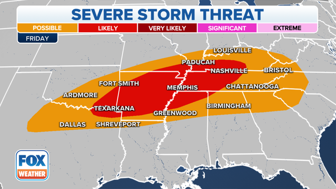
Severe thunderstorm threat on Friday, Dec. 31, 2021.
(FOX Weather)
A large area of the South is also at risk for additional severe storms on Saturday (New Year's Day).
At this time, it appears eastern Mississippi into central and northern Alabama is likely the region where a greater severe weather threat may exist to kick off the new year. Similar to Friday, the thunderstorms will be capable of all severe-weather hazards, including large hail, damaging wind gusts and a few tornadoes.
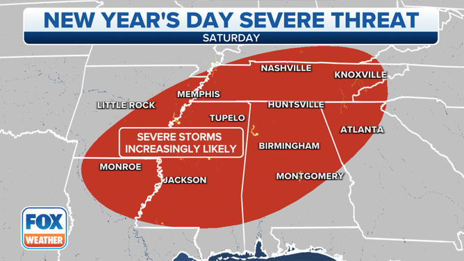
Severe thunderstorm threat on Saturday, Jan. 1, 2022.
(FOX Weather)