Severe storms, flooding possible across parts of Southeast on Wednesday
The severe weather threat wanes for much of the nation on Wednesday, with just a low risk of severe thunderstorms capable of damaging winds across parts of the Southeast, including Birmingham, Alabama and Jackson, Mississippi.

Heavy rain, widespread storms possible from Gulf Coast to Southeast on Wednesday
It's rinse and repeat across the Southeast as storms are expected to roll in again on Wednesday.
It's rinse and repeat across the Southeast as thunderstorms are expected to roll in again on Wednesday.
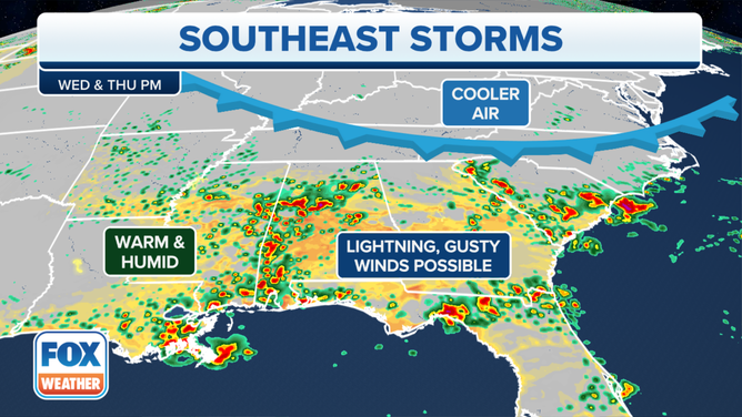
More storms are likely across the Southeast on Wednesday and Thursday evening.�
(FOX Weather)
The severe weather threat wanes for much of the nation on Wednesday compared to the past few days, with just a low risk of severe thunderstorms capable of damaging winds across parts of the Southeast, including Birmingham, Alabama and Jackson, Mississippi.
Even those in the Atlanta metro area will end up seeing some scattered rain showers, which will likely happen just in time for the evening rush hour.

(FOX Weather)
"It's a lower warning than (Tuesday)," said FOX Weather meteorologist Britta Merwin. "(Tuesday), we were 3 out of 5 (SPC severe weather risk). Today, a 1 out of 5. So the majority of you will just experience your garden variety thunderstorms."
However, these summertime storms can still be dangerous, with frequent lightning and gusty winds.
"The concern is strong straight line winds," Merwin said. "We could see some wind gusts in excess of 65 mph. That's enough that you can do a little damage to some fencing."
These storms will also remain nearly stationary, which will allow for periods of heavy rain and some potential for flash flooding, according to the FOX Forecast Center. Indications are storm coverage will begin to decrease on Friday.
(FOX Weather)
A second low risk area is in the northern Plains and Rockies along a frontal boundary that stretches from South Dakota into northern Texas on Wednesday. Again, a few thunderstorms could bring damaging wind gusts to 60 mph.