Southern Plains slammed by severe weather Friday with damage across three states
Already dozens of structures were damaged by a tornado in Arkansas while other damage reports are coming in from Oklahoma. More severe storms are likely through Friday evening.
Weekend weather outlook
FOX Weather meteorologist Steve Bender has a look at who will see storms over the weekend.
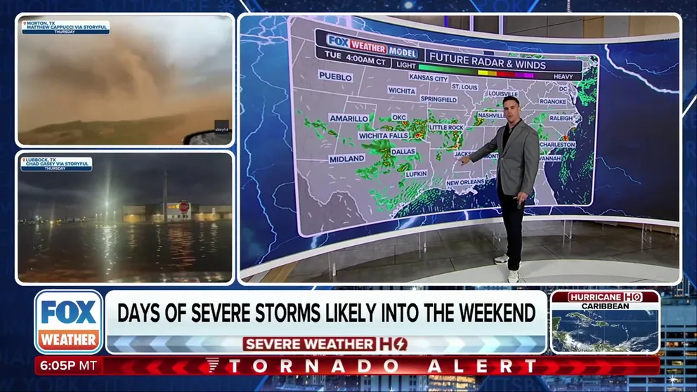
LUBBOCK, Texas – A pattern that shows no signs of relaxing is producing strong to severe thunderstorms through the weekend and well into the upcoming workweek, with only slight variations from day to day.
On Friday, many of the areas that were impacted by severe storms on Thursday saw an additional round of thunderstorms, with Tornado Watches that lasted into the evening.
During the height of the activity, nearly 5 million residents were underneath Tornado Watches, which included the city of Lubbock, Texas, which was hit hard by tornadic supercells on Thursday.
Lubbock wasn't the only area that saw significant weather - a severe thunderstorm in Arkansas spun up a damaging tornado in Van Buren. Emergency managers reported at least 50 structures sustained damage in a neighborhood.

Tornado damage in Van Buren, Arkansas.
(Joshua Mannion / FOX Weather)
A tornado-warned storm was caught on a traffic camera as it swept through Fort Smith, Arkansas as the line of storms pushed east Friday morning.

Tornado-warned storm sweeps through Fort Smith, AR
A tornado-warned storm was caught on a traffic camera as it swept through Fort Smith, AR on Friday morning.
An apparent tornado was spotted by police Friday morning near Vian, Oklahoma as a tornado-warned storm moved through Sequoyah County.
The storms were strong enough to rip down trees and close local roads in Luther, Oklahoma, according to the fire department.
WATCH: SUPERCELL CUTS PATH THROUGH 2 STATES, PRODUCING TORNADOES LIVE ON FOX WEATHER

Apparent tornado looms near Vian, OK Friday
An apparent tornado was spotted near Vian, OK on Friday morning as tornado-warned thunderstorms swept through the area.
An apparent tornado was spotted by police Friday morning near Vian, Oklahoma as a tornado-warned storm moved through Sequoyah County.
The storms were strong enough to rip down trees and close local roads in Luther, Oklahoma, according to the fire department.
WATCH: DRONE VIDEO SHOWS GIANT WAVE SWALLOWING UP SWIMMERS ON MEXICAN BEACH
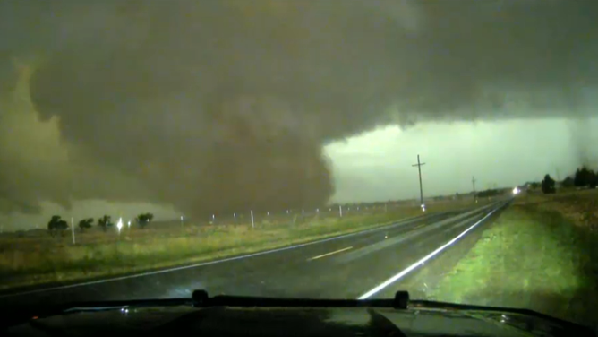
![Photo of a supercell in West Texas on 6/6/2025]() Image 1 of 12
Image 1 of 12Photo of a supercell in West Texas on 6/6/2025 (Brandon Copic)
![Metal debris is twisted around power lines and telephone pole in Van Buren, Arkansas.]() Image 2 of 12
Image 2 of 12Metal debris is twisted around power lines and telephone pole in Van Buren, Arkansas. (Joshua Mannion)
![Tornado damage in Van Buren, Arkansas.]() Image 3 of 12
Image 3 of 12Tornado damage in Van Buren, Arkansas. (Joshua Mannion)
![The fire department in Luther, Oklahoma responded to trees brought down after severe storms Friday, June 6, 2025.]() Image 4 of 12
Image 4 of 12The fire department in Luther, Oklahoma responded to trees brought down after severe storms Friday, June 6, 2025. (Luther Fire Department)
![The fire department in Luther, Oklahoma responded to trees brought down after severe storms Friday, June 6, 2025.]() Image 5 of 12
Image 5 of 12The fire department in Luther, Oklahoma responded to trees brought down after severe storms Friday, June 6, 2025. (Luther Fire Department)
![The fire department in Luther, Oklahoma responded to trees brought down after severe storms Friday, June 6, 2025.]() Image 6 of 12
Image 6 of 12The fire department in Luther, Oklahoma responded to trees brought down after severe storms Friday, June 6, 2025. (Luther Fire Department)
![Damage caused by severe storms in Vian, Oklahoma Friday morning, June 6, 2025]() Image 7 of 12
Image 7 of 12Damage caused by severe storms in Vian, Oklahoma Friday morning, June 6, 2025. (Vian Police Department/Facebook)
![Damage caused by severe storms in Vian, Oklahoma Friday morning, June 6, 2025]() Image 8 of 12
Image 8 of 12Damage caused by severe storms in Vian, Oklahoma Friday morning, June 6, 2025 (Vian Police Department/Facebook)
![FOX Weather Exclusive Storm Tracker Brandon Copic intercepts tornado toucheing down in Shallowater, Texas on June 5, 2025.]() Image 9 of 12
Image 9 of 12FOX Weather Exclusive Storm Tracker Brandon Copic intercepts tornado toucheing down in Shallowater, Texas on June 5, 2025. (FOX Weather)
![Damage caused by severe storms in Vian, Oklahoma Friday morning, June 6, 2025]() Image 10 of 12
Image 10 of 12Damage caused by severe storms in Vian, Oklahoma Friday morning, June 6, 2025 (Vian Police Department/Facebook)
![Flash flooding in Lubbock, Texas in the wake of severe storms on June 5, 2025.]() Image 11 of 12
Image 11 of 12Flash flooding in Lubbock, Texas in the wake of severe storms on June 5, 2025. (Chad Casey via Storyful)
![Hail comparison over West Lubbock, Texas 6/5/2025.]() Image 12 of 12
Image 12 of 12Hail comparison over West Lubbock, Texas 6/5/2025. (@myprojectpluto)


During the next several days, storms are expected to develop daily in the afternoons and evenings, with leftover energy driving some thunderstorm formation in the overnight hours. The threat is expected to gradually move east as the weekend progresses.
"It's like all of this action has been riding the [Interstate]-40 corridor and the I-40 corridor has been the focus of all the action this entire week," FOX Weather Meteorologist Britta Merwin said.

(FOX Weather)
Severe storms bring weekend flash flood threat for Southern Plains, Deep South
Tropical moisture from the Gulf will enhance severe storms through the weekend, meaning that they will be able to produce lots of rain in a short amount of time.
Rain rates have the potential to easily exceed 1 inch per hour at times.
Storms Friday morning produced enough rain to cause flash flooding in Ada, Oklahoma.

Severe storms trigger flash flooding in Ada, Oklahoma
Severe thunderstorms caused flash flooding in Ada, Oklahoma (Video Credit: @mattellis1233/X).
Although the storms are expected to move at a decent pace, the setup may allow some areas to experience repeated rounds of heavy rain. This "training" effect—where storms repeatedly form over the same locations, could lead to totals exceeding 3 inches, and possibly as high as 5 inches by the time it's all over.

(FOX Weather)