Severe thunderstorms with large hail, tornadoes possible in the Midwest on Sunday
Cities in Illinois such as Peoria and Springfield and communities in Indiana such as Indianapolis and Bloomington are all in the likely threat zone for severe weather on Sunday.
Severe storms will march across Midwest into Northeast Sunday and Monday
Tornados, high winds and large hail are possible across the Midwest Sunday then threaten the Northeast on back-to-work Monday.
A slow-moving cold front will creep through the Midwest on Sunday and will help to trigger strong to severe thunderstorms.
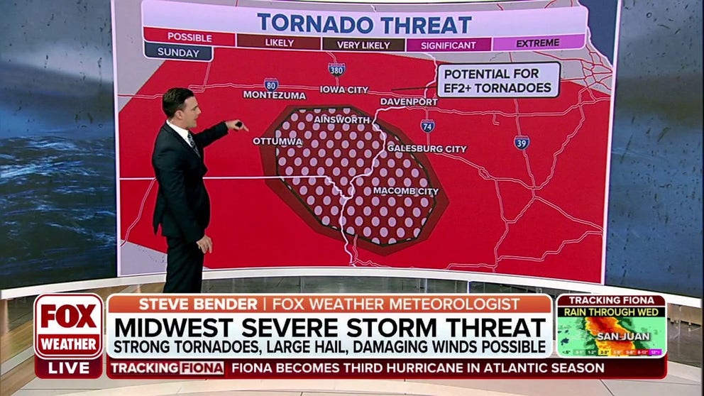
Severe thunderstorms are possible across a large area of the region that stretches from southeastern Iowa and northeastern Missouri, through Illinois and Indiana.
However, the highest risk is centered across southeastern Iowa, including Davenport, and portions of northwestern Illinois, including the cities of Peoria and Springfield.
The FOX Forecast Center believes all modes of severe weather, which includes damaging wind, hail and tornadoes, will be possible, especially during the late afternoon and evening hours.

(FOX Weather)
Once storms develop, they will have a tendency to move eastward to east-southeastward as long as sufficient atmospheric conditions exist.
FALL IS THE SECOND SEVERE WEATHER SEASON
The storm system will move eastward through the evening and could spawn a few showers on storms on Monday along the eastern Great Lakes and the Northeast.
Unlike on Sunday, the threat should be minimal, with only isolated chances for few strong storms, which could produce gusty winds and hail.
Rainfall accumulations are expected to remain light, with many areas seeing less than an inch of rain.

(FOX Weather)