Rockies could get first snowstorm of the season next week
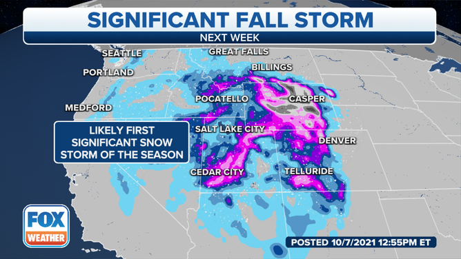
Forecast charts indicate the first snowstorm of the season is looming for the Rocky Mountains and parts of the Intermountain West, with over a foot of snow possible in higher elevations if current projections pan out.
(FOX Weather)
SALT LAKE CITY – The first snowstorm of the season is looming for the Rocky Mountains and parts of the Intermountain West, with over a foot of snow possible in higher elevations if current projections pan out.
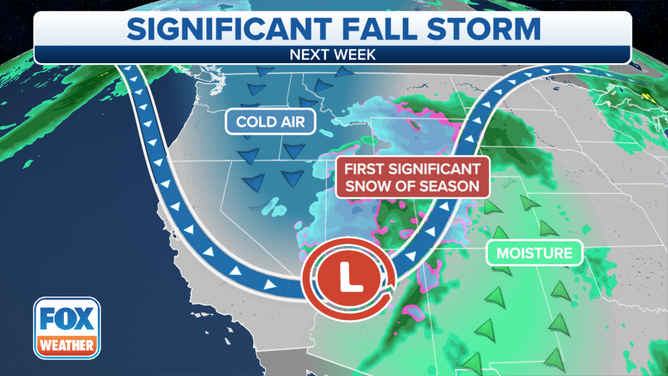
A strong upper level trough is expected to dig into the inland West from the Pacific Northwest by late in the weekend, bringing along the coldest weather of the season thus far.
The exact timing of the storm is still in flux as we sit four to five days out from the event. Still, mountain snows are expected to begin in eastern Idaho, southern Montana, northeastern Nevada early Monday, spreading across Utah and into Wyoming by later on Monday.
Heavy snows are possible across much of the northern and central Rockies Monday night into Tuesday, with even a chance of a bit of snow in Salt Lake City and Denver.
"This does have the potential to be one of the first higher impact events of the winter season," says FOX Weather meteorologist Jordan Overton. "It’s a reminder that we should all be reviewing our winter weather safety plans and prepare our winter weather safety kits. The exact details of this system will become more clear over the next few days, and it’s important to check back on the forecast often!"
Even areas outside the snowfall will notice temperatures plummet. Whereas temperatures were generally in the 60s across the region Thursday, they are expected to be stuck in the 30s or 40s on Tuesday across the Central Great Basin and even northern Arizona. Those levels are between 15 and 30 degrees below average.