Rainy start to the week in Northeast as backdoor cold front brings numerous showers, thunderstorms
A backdoor cold front is one that moves in from the east or northeast
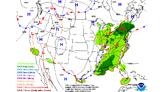
A backdoor cold front is draped across the Northeast, bringing showers and thunderstorms to the region early this week.
(NOAA's Weather Prediction Center)
Multiple rounds of showers and thunderstorms will move through the Northeast and mid-Atlantic early this week as a backdoor cold front drapes itself across the region.
While a typical cold front moves in from the west or northwest, a backdoor cold front is the opposite: It moves in from the east or northeast.
This particular front was situated from the Southern Tier of New York to northern New Jersey as of Monday morning. It's predicted to drift southward into Pennsylvania and central New Jersey later Monday, then stall over Delaware and Maryland on Tuesday.
The result will be a rainy start to the workweek for much of the region as numerous showers and thunderstorms develop along the backdoor cold front.
NOAA's Weather Prediction Center has highlighted a broad area from southeastern Michigan and northern Ohio eastward into southern New England for a marginal risk (level 1 out of 4) of excessive rainfall on Monday. Rainfall rates up to 1 inch per hour are expected in the heaviest downpours, which could be high enough to yield isolated flash flooding issues.
A few lingering showers are possible on Tuesday, but the rain won't be as widespread as Monday, so the risk for additional flash flooding is low.
In general, 1 to 2 inches of total rain is predicted through Tuesday night. Localized amounts up to 3 inches are possible, especially in southern New England.
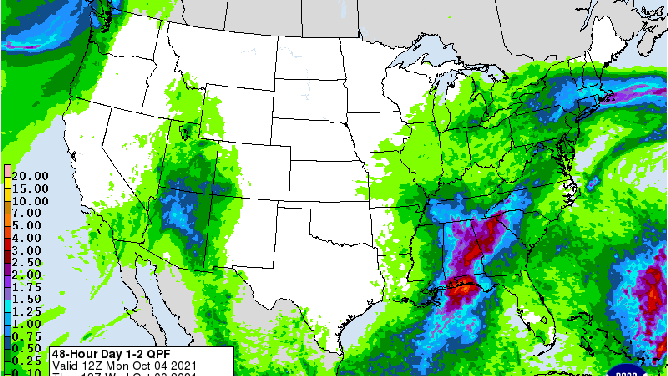
NOAA's rainfall forecast through early Wednesday morning, Oct. 6, 2021.
(NOAA's Weather Prediction Center)
High pressure should bring drier conditions to the Northeast by Wednesday.