Rain, thunderstorms return to Southern California forecast
The bulk of the storms are expected to trigger Monday evening into Monday night, possibly lingering into early Tuesday.
LOS ANGELES -- Sunshine is taking a bit of a break around Los Angeles and San Diego later Monday as an upper level low tracks into southern California, bringing a chance of showers and thunderstorms.
Clouds will begin building later Monday afternoon, but the bulk of the storms are expected to trigger Monday evening into Monday night, possibly lingering into early Tuesday.
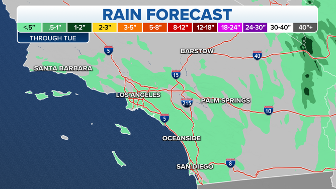
The rainfall will be showery, meaning some areas could dodge the rain while others will be picked on a bit. Some of the showers may last long enough to bring minor flooding issues. Overall light amounts are forecast around Los Angeles with heavier amounts expected farther south toward San Diego and east into the mountains, where around a quarter-inch or more of rain could fall.
Here is the current projection for rainfall through Tuesday afternoon. #CAwx pic.twitter.com/hCVhaI1GJp
— NWS San Diego (@NWSSanDiego) October 4, 2021
There is enough atmospheric instability for some showers to intensify into thunderstorms that may bring isolated bursts of heavy rain, frequent lightning and gusty winds.
Some of the lightning may occur outside where it's raining, bringing a risk of triggering new wildfires.
San Diego just had a half-inch of rainfall last week as a band of thunderstorms moved through, but any rainfall that makes it into Downtown Los Angeles will be the first in quite some time. The rain gauge at the USC campus has only measured one day of rainfall since June 26 -- a paltry 0.01 inches on Sept. 10.
There's a chance of showers/storms for L.A. and Ventura Co Mon afternoon-night. As is typical with this type of showers/storms, some areas will get rain and other spots will stay dry. Keep an eye on the radar to see if you are in the path, & plan outdoor work accordingly. #socal pic.twitter.com/2F0YjYVBMQ
— NWS Los Angeles (@NWSLosAngeles) October 3, 2021
The showers will scoot off to the east by Tuesday morning, leaving the rest of the day as a more familiar dry and sunny day, though temperatures will be a tad below average, dropping into the mid-upper 70s.
Cooler air moves in later this week, with high temperatures dropping into the mid-60s to near 70. Overnight temperatures in the outlying areas will fall into the 50s.