Déjà vu: Temperatures in the Pacific Northwest soar on year anniversary of record-breaking heat wave
In June 2021, Oregon cities experienced all-time record high temperatures
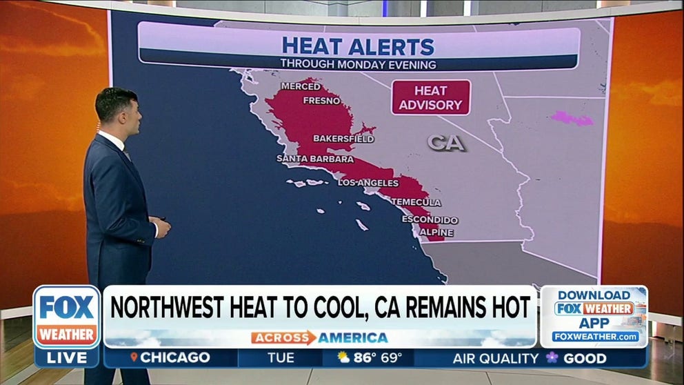
Heat alerts remain in effect for Pacific Northwest through Monday
Heat alerts will stick around for parts of the Pacific Northwest through Monday evening.
The summer swelter is underway in the Pacific Northwest amid a heat wave occurring on the anniversary of last year's record-breaking heat wave.
Last year, parts of Oregon and Washington set new records with high temperatures well above 100 degrees on June 26 and 27. This week, temperatures are hot but not nearly as scorching as last summer.
HOW TO WATCH FOX WEATHER ON TV
Associate Prof and director of Oregon Climate Services Larry O’Neill said the 2021 summer heat wave was an unprecedented event, which set 116 all-time temperature records across the state.
On June 27, 2021, Portland hit 112 degrees and the following day reached 116, a record for the city. Eugene, Salem, Astoria and McMinnville also set all-time records on June 27.
"The heat wave that we are currently experiencing is actually very seasonable, so this is a very typical heat wave, but people are really on edge because this is happening at the same time as last year’s unprecedented heat wave."
On Sunday, the NWS in Seattle/Tacoma tweeted that Seattle-Tacoma International Airport reached over 90 degrees for two years in a row. Last year on June 26, the high was 102 degrees.
Temperatures on Monday were between 10 and 30 degrees higher than average, but there is good news for the Pacific Northwest with a cool down coming.
WHAT IS THE HEAT INDEX AND WHY IS IT IMPORTANT TO YOUR HEALTH?
The heat peaked Monday with highs hitting the 90s and 100s outside the coast and mountains, still nowhere near the 110+ temperatures of last summer's heatwave.
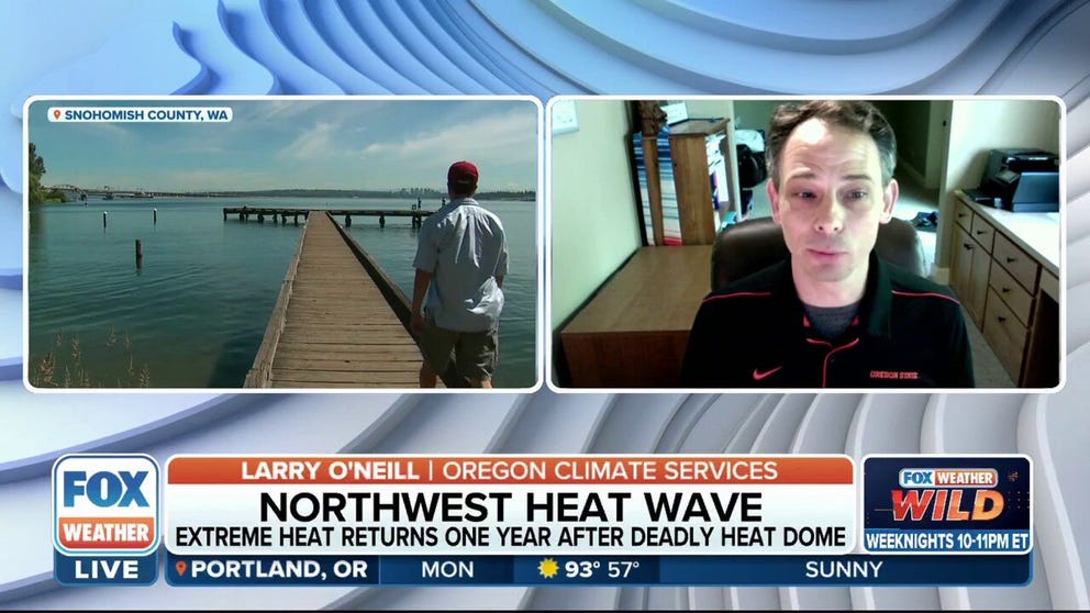
Extreme heat returns to Pacific Northwest one year after record-breaking heat wave
Larry O'Neill, Associate Professor and Director of Oregon Climate Services, joined FOX Weather to discuss the year anniversary of the record-breaking heat wave in Oregon and the Pacific Northwest as temperatures soar on Monday.
O'Neill said forecast models last year aligned about 10 days out of the deadly heat wave that temperatures would reach 115-120 degrees.
"This was bonkers," O'Neill said forecasters thought at the time. "This was so far out of normal range that there must have been something wrong."
However, those models proved true during the historic weather event.
"That's the thing about a changing climate is that the past is starting to become less of a predictor for us to kind of evaluate the reasonableness of a forecast about 10 days out," O'Neill said.
Relief on the way
![]() Image 1 of 2
Image 1 of 2Northwest temperatures compared to average this time of year. ( )
![High temperatures forecast across the Pacific Northwest on Tuesday.]() Image 2 of 2
Image 2 of 2High temperatures forecast across the Northwest on Tuesday. ( )


By mid-week, the above-average temperatures will shift away from the Northwest and back to the Plains by Wednesday.
According to the NWS Seattle, there is one more hot day up and down the Interstate 5 corridor before cool marine air pushes in Monday night into Tuesday.
WHEN SECONDS MATTER: CHILDREN EXPERIENCE HEATSTROKE SYMPTOMS WITHIN MINUTES OF BEING IN A HOT CAR
A surge of cool air moving along the Oregon coast will bring relief along the coast later Monday but won't drop temperatures inland until Tuesday.
The Portland metro area will be the last to cool down Monday evening, according to the NWS Portland. Temperatures will be in the mid-70s to the lower 80s near into the overnight hours.
This slow cool down is partly due to urban heating effects like large areas of asphalt and concrete. Urban areas tend to retain heat longer than green open spaces.
CLICK HERE TO GET THE FOX WEATHER UPDATE PODCAST
Be sure to download the FOX Weather app to track any storms in your area and receive potentially life-saving weather alerts issued by the National Weather Service. The free FOX Weather livestream is also available 24/7 on the website and app and on your favorite streaming platform. The FOX Weather Update podcast also provides weather information for the entire country.