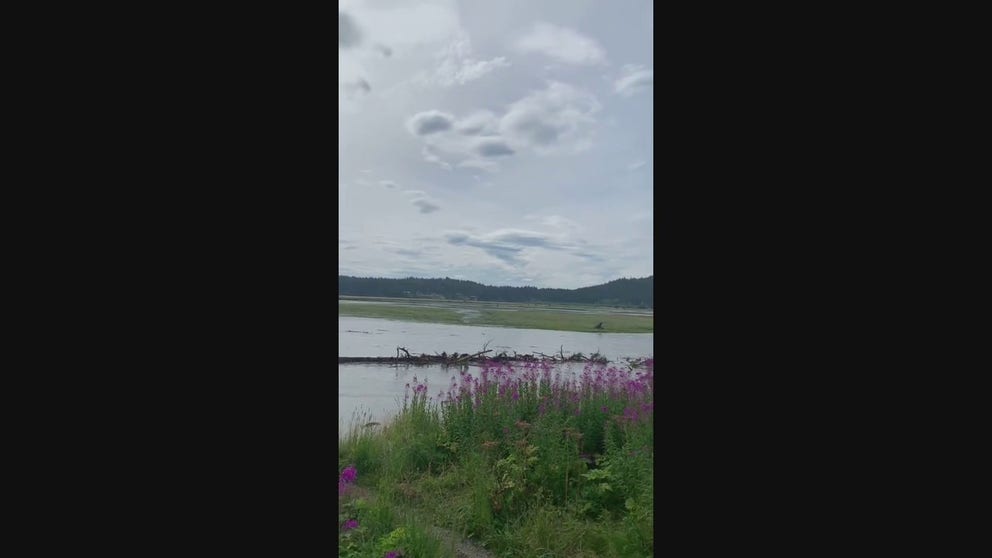
See Alaska's raging Mendenhall River erode riverbank prompting evacuations as buildings, trees get swept away
According to the National Weather Service, the Mendenhall Lake gage crested around 11:15 p.m. AKDT Saturday with a maximum level of 14.97 feet – well above the previous record flood stage of 11.99 feet set back in 2016.
Watch: Trees swept down Mendenhall River due to significant flooding
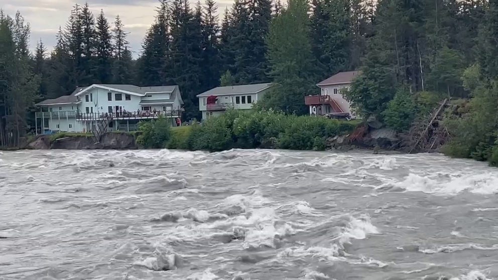
A large tree is seen being swept down the Mendenhall River in Juneau, Alaska, after significant flooding on Saturday, August 5, 2023.
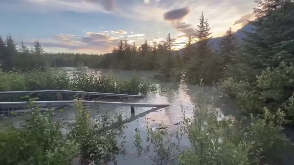
JUNEAU, Alaska – Floodwaters are finally receding along a river in Alaska after a major release at the Suicide Basin of the Mendenhall Glacier above Juneau that sent record amounts of water rushing downstream, forcing the evacuation of several areas on Saturday.
According to the National Weather Service, the Mendenhall Lake gage crested around 11:15 p.m. AKDT Saturday with a maximum level of 14.97 feet – well above the previous record flood stage of 11.99 feet set back in 2016.
Watch: Raging Mendenhall River erodes riverbank as water rushes downstream
Water is seen rushing down the Mendenhall River in Alaska after a major release of water within the Mendenhall Glacier - one of Alaska's top tourist destinations.
Several feet of water were reported in areas along the Mendenhall River after the glacier-dammed lake outburst, as well as inside homes that have not previously seen flooding.
What is a glacier-dammed lake outburst?
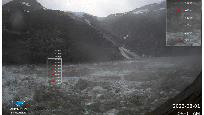
A time lapse image of water levels dropping inside Suicide Basin of the Mendenhall Glacier.
(National Weather Service)
According to the National Weather Service, outburst floods are caused by the rapid release of water from a glacier-dammed lake.
Glacier-dammed lakes are formed when a glacier blocks water flow out of a tributary valley. And as the seasons change, rainfall, rainfall runoff, snowfall, snowmelt and glacier melt all accumulate in the lake.
Then at semi-regular intervals, which can vary between each lake, the lake begins a self-emptying process. A fracture will allow water to start to flow out of the lake, and that fracture will then grow larger and larger as it melts due to the heat created by the potential energy flowing through it, according to the NWS.
![Water is rushing down the Mendenhall River in Alaska and eroding the riverbank on Saturday, August 5, 2023.]() Image 1 of 9
Image 1 of 9Water is rushing down the Mendenhall River in Alaska and eroding the riverbank on Saturday, August 5, 2023. (Kayla Browning/Facebook)
![Water is seen rushing down the Mendenhall River in Alaska on Saturday, August 5, 2023.]() Image 2 of 9
Image 2 of 9Water is seen rushing down the Mendenhall River in Alaska on Saturday, August 5, 2023. (Kayla Browning/Facebook)
![This image shows a tree falling into the Mendenhall River in Alaska on Saturday, August 5, 2023.]() Image 3 of 9
Image 3 of 9This image shows a tree falling into the Mendenhall River in Alaska on Saturday, August 5, 2023. (Kayla Browning/Facebook)
![This photo shows a raging Mendenhall River in Alaska on Saturday, August 5, 2023.]() Image 4 of 9
Image 4 of 9This photo shows a raging Mendenhall River in Alaska on Saturday, August 5, 2023. (Kayla Browning/Facebook)
![Flooding is seen along the Mendenhall River in Juneau, Alaska.]() Image 5 of 9
Image 5 of 9Flooding is seen along the Mendenhall River in Juneau, Alaska. (Kayla Browning)
![FILE - Mendenhall Glacier in the Tongass National Forest near the city of Juneau, Alaska, Tuesday, July 6, 2021.]() Image 6 of 9
Image 6 of 9FILE - Mendenhall Glacier in the Tongass National Forest near the city of Juneau, Alaska, Tuesday, July 6, 2021. (Salwan Georges/The Washington Post)
![These images from the National Weather Service show an area known as Skater’s Cabin. The first photo on the left was taken at 6:30 a.m. local time on Saturday and the photo on the right shows what it looked like at 1:30 p.m.]() Image 7 of 9
Image 7 of 9These images from the National Weather Service show an area known as Skater’s Cabin. The first photo on the left was taken at 6:30 a.m. local time on Saturday and the photo on the right shows what it looked like at 1:30 p.m. (National Weather Service Juneau)
![A major release at the Suicide Basin in Juneau, Alaska, sent water rushing into Mendenhall Lake and River leading to significant and historic flooding on Saturday.]() Image 8 of 9
Image 8 of 9A major release at the Suicide Basin in Juneau, Alaska, sent water rushing into Mendenhall Lake and River leading to significant and historic flooding on Saturday. (Alaska Electric Light & Power/Twitter)
![A time lapse image of water levels dropping inside Suicide Basin of the Mendenhall Glacier.]() Image 9 of 9
Image 9 of 9A time lapse image of water levels dropping inside Suicide Basin of the Mendenhall Glacier. (National Weather Service)


After the lake empties, it freezes again, and the process starts all over.
Regarding Suicide Basin, glacier lake outburst floods have occurred since 2011 and have caused inundation along Mendenhall Lake and Mendenhall River.
Structures, trees swept away by Mendenhall River
In addition, the NWS reports that significant bank erosion along the river has occurred, with structures and large trees collapsing into the river on Saturday evening and being swept downstream.
Watch: Debris seen floating down Mendenhall River in Juneau, Alaska
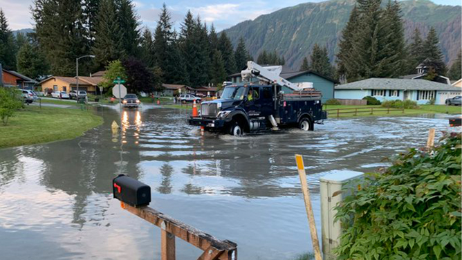
Evacuations were ordered and buildings have been washed away after a major release at the Suicide Basin in Juneau, Alaska, on Saturday, August 5, 2023.
Juneau city officials said several roads had been closed due to the flooding, and affected residents had been notified to leave the area while the flooding was ongoing.
Residents were also asked to limit vehicle activity on the Mendenhall River bridge on Back Loop to essential travel only and not to try and visit the area to observe the flooding incident.
When the record-breaking flooding was occurring, Alaska Electric Light and Power Company cut off electric supplies to several areas as a precaution.
Watch: Record flooding occurs along Mendenhall River in Alaska
Glacier-dammed outburst flooding occurred in Alaska on Saturday leading to record-breaking flooding along the Mendenhall River.
Those areas without electricity included the Mendenhall Campground, View Drive, Meander Way and Stream Court. However, as water levels began to recede, power was slowly starting to be restored in affected areas.
The NWS said Flood Warnings for areas around Mendenhall Lake and River would continue until 10 a.m. AKDT.
The U.S. Coast Guard was also warning mariners to use caution when navigating the waters due to the amount of debris in the area.

FILE - Mendenhall Glacier in the Tongass National Forest near the city of Juneau, Alaska, Tuesday, July 6, 2021.
(Salwan Georges/The Washington Post / Getty Images)
The Mendenhall Glacier is a 13-mile-long river of ice within the Tongass National Forest and is among one of the top tourist destinations in Alaska.
According to the Bureau of Land Management, nearly 700,000 people visit Alaska's Mendenhall Glacier every year. It's about 12 miles from downtown Juneau, making it one of the most accessible glaciers in the U.S.
The glacier is just one of many that connect to the Juneau Ice Field, a 1,500 square-mile remnant of the last ice age, according to the U.S. Forest Service.