Kona Low over Hawaii weakens after bringing 10 inches of rain to Maui, snow to Mauna Kea summits
By Saturday night and Sunday, a much more stable airmass will become established over the islands, and typical northeast trade winds will begin to return. The trades will strengthen early next week, with stable trade wind weather prevailing through mid-week, the the FOX Forecast Center adds.
Kona Low over Hawaii weakens as dry weather returns Sunday
The Kona Low, a weather system that caused continuous rain and messiness in the Hawaiian islands, is gradually losing its strength, the FOX Forecast Center said.
HONOLULU – The Kona Low, a weather system that caused continuous rain and messiness in the Hawaiian islands, is gradually losing its strength, the FOX Forecast Center said.
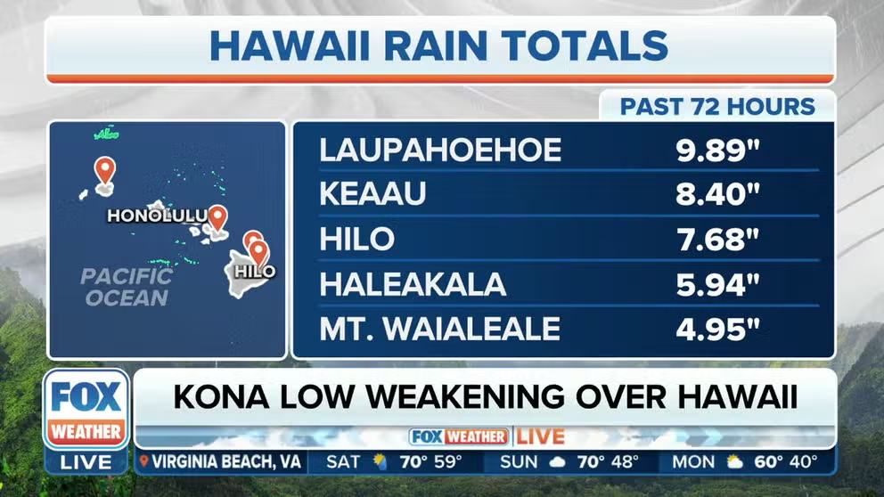
Before its weakening, it resulted in the accumulation of almost 10 inches of rain in eastern Maui and 1-2 feet of rainfall on the Big Island.
Radar estimates indicate that Windward Haleakala has received 1 to 2 feet of rainfall due to southeasterly surface flow that has caused rain and storms to be concentrated on the terrain. The rainfall rate in this area has been consistently around 2 inches per hour, with occasional bursts of up to 4 inches per hour during the peak of the storm.
"Over portions close to Honolulu, there have been reports of big rocks, boulders, the size of small cars sliding down the mountains," FOX Weather Meteorologist Craig Herrera said. "Thankfully, no one has been hurt or injured, but this is the type of rain that will do that."
HOW MOUNTAINS CAN HOG THE RAIN
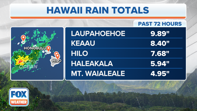
The top rainfall reports in Hawaii for Dec. 1, 2023.
(FOX Weather)
Steady heavy rain fell on the southeast and the windward slopes of the Hilo and Puna Districts of the Big Island. Rain rates have been equivalent to those seen on Maui.
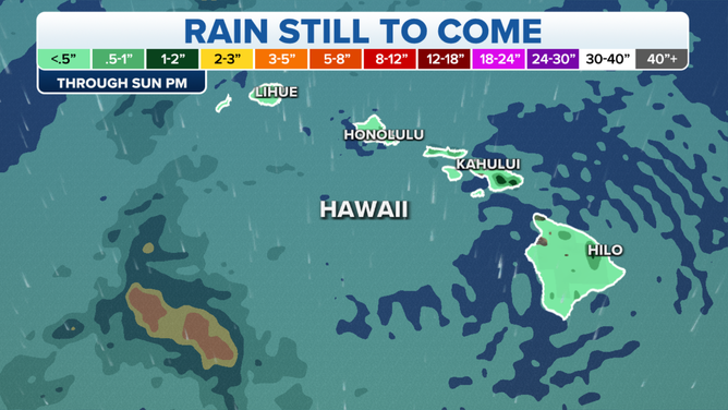
The rainfall forecast for Hawaii through Dec. 3, 2023.
(FOX Weather)
But good news for those looking for a break from the rain.
By Saturday night and Sunday, a much more stable airmass will become established over the islands, and typical northeast trade winds will begin to return.
The trades will strengthen early next week, with stable trade wind weather prevailing through mid-week, the FOX Forecast Center adds.
Flood Watches, once in effect for the entire state, have been allowed to expire.
The rains were at least a welcome respite from the ongoing drought. The latest U.S. Drought Monitor report indicated that more than 93% of the state was currently experiencing moderate drought, with 75% facing severe drought before the Kona Low arrived.
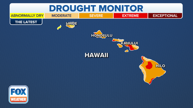
A look the latest U.S. Drought Monitor report fro Hawaii.
(FOX Weather)
Snow, gusty winds hit Hawaii's Mauna Kea Summit
It wasn't heavy rain, but heavy snow that fell across Hawaii's Mauna Kea summit due to the Kona Low.

First snow of year falls on Hawaii's Big Island
Snow and gusty winds lashed the summit of Hawaii’s Mauna Kea on Wednesday as a Kona Low system brought stormy weather to the state.
The inactive volcano Mauna Kea, which stands at an elevation of 13,800 feet, has received several inches of snow.
Footage from Derek Petrowski captured Wednesday showed gusty wind and snow outside the Keck Observatory, an astronomical observatory near the summit of Mauna Kea.
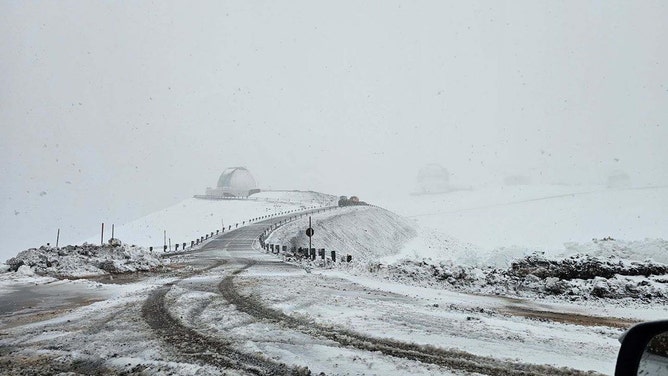
![Snow continued to fall Thursday on the summit of Mauna Kea Observatory. The road to the summit is closed until further notice due to icy conditions.]() Image 1 of 2
Image 1 of 2Snow continued to fall Thursday on the summit of Mauna Kea Observatory. The road to the summit is closed until further notice due to icy conditions. (Center for Maunakea Stewardship Rangers)
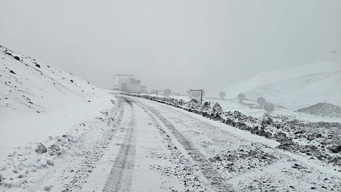
![Snow continued to fall Thursday on the summit of Mauna Kea Observatory. The road to the summit is closed until further notice due to icy conditions.]() Image 2 of 2
Image 2 of 2Snow continued to fall Thursday on the summit of Mauna Kea Observatory. The road to the summit is closed until further notice due to icy conditions. (Center for Maunakea Stewardship Rangers)
Petrowski said that he "arrived at work to see that the Kona low weather system brought freezing temps and precipitation to the Summit of Mauna Kea overnight."
According to Petrowski, the snow on Hawaii's Big Island was the first of the year.
Why Kona Lows can be so dangerous
Kona Lows have had a history of trouble in Hawaii, with their tropically infused downpours overwhelming the state with torrential rain and sometimes damaging wind gusts.
A Kona Low that struck in December 2021 dropped 2 feet of rain in Maui, washing some cars away. On Oahu, strong winds at Honolulu's airport blew a shed into parked planes, damaging the aircraft.
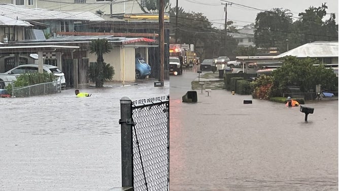
The Pearl City Road Maintenance Division had to wade chest deep in floodwater to clear storm drains in December 2021.
(Honolulu Mayor/Honolulu DEM / NOAA)
At Mauna Kea's summit, wind gusts of more than 100 mph created whiteout conditions, blowing around the 10 inches of snow that fell during the storm.
HOW A TROPICAL PARADISE IS HOME TO THE RAINIEST SPOT IN THE NATION
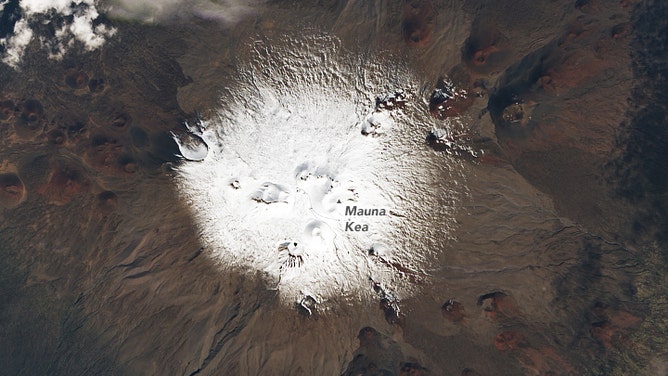
A snow-capped Mauna Kea on Hawaii on Dec. 7, 2021, as seen by Operational Land Imager (OLI) on Landsat 8.
(NASA / NASA)
In 2018, a Kona Low dropped a record-setting 49.69 inches of rain in 24 hours over Waipa Gardens on Kauai on April 14-15.