It's eerily quiet in the Atlantic, but what does it mean for the rest of hurricane season?
For what has been a very active hurricane season, the Atlantic has been relatively quiet over the past couple of weeks.
Sam became post-tropical at the beginning of October, and the Atlantic hasn't seen a significant system since.
The hurricane season ends at the end of November, and Dr. Phil Klotzbach believes we will still have more activity before it ends, even though it has been quiet.
Klotzbach is a meteorologist and research scientist at Colorado State University. He specializes in the Atlantic basin seasonal hurricane forecasts. He and his team at the university put out a forecast every year separate from NOAA's.
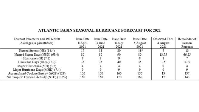
Colorado State University Atlantic Basin Seasonal Hurricane Forecast for 2021.
(Colorado State University)
The Colorado State forecast should verify as there have been 20 named storms. Seven of those named storms were hurricanes, and four were major hurricanes.
But why has the season gone quiet?
The upper-level winds are a big reason for the inactivity in the Atlantic.
"We've generally had stronger than normal shear, especially in the western Atlantic where we typically get strong storm activity late in the season," Klotzbach says. "Since zonal shear in the tropical Atlantic is typically westerly, anomalously strong westerly shear means stronger than normal shear."
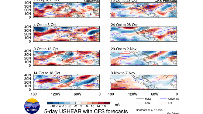
This is the observed shear over the past few weeks and the forecast shear for the next few weeks.
(Climate Forecast System)
The graphics above show the observed shear over the past several weeks and the forecast shear from the Climate Forecast System for the next few weeks.
Given the trend towards La Niña, which typically reduces the Atlantic vertical wind shear, Klotzbach says the stronger than average shear the past few weeks is surprising.
"We also have sub-seasonal variability which can either act to amplify or counteract ENSO's impacts. In this case, the Madden Julian oscillation has generally been enhancing convection over the tropical Pacific, which acts to dampen the La Niña signal temporarily," Klotzbach explains. "However, the MJO is forecasted by the ECMWF and GFS to move into the tropical Atlantic and Africa over the next week or so, which should reduce Atlantic vertical wind shear."
So when will it pick back up?
The Climate Forecast System forecasting lower shear in the next couple of weeks could mean a pickup in activity over the Atlantic.
While the next week continues to look quiet, Klotzbach says that models hint at development in the Caribbean in late October or early November.
Here's the 10-12-day ensemble forecast from ECMWF.
(WeatherModels.com)
The European Centre for Medium-Range Weather Forecast shows the potential for tropical development at the end of the month.
The Global Ensemble Forecast System also shows something similar for that timeframe as well.
What does history show?
Major hurricane development in November is possible.
There have been six major hurricanes that have formed in the last month of hurricane season.
- Lenny (1999)
- Michelle (2001)
- Paloma (2008)
- Otto (2016)
- Eta (2020)
- Iota (2020)
"It's rather unusual to get major hurricanes in November, but it wouldn't be unprecedented," Klotzbach says.