Ida poses dangerous flooding threat from the South into the Northeast
Some areas could receive more than 6 inches of rain by Thursday morning

2 dead as cars plunge from Mississippi highway washed out from Hurricane Ida rains
Two people were killed and 10 others were injured when heavy rains from the remnants of Hurricane Ida washed out a busy highway in southern Mississippi.
Heavy rainfall from Ida will spread northeastward from the South into the Northeast through Thursday morning, posing a dangerous risk of flooding for millions of Americans.
The National Weather Service has issued Flood and Flash Flood Watches from the Florida Panhandle to Massachusetts. As of Tuesday morning, more than 80 million people in the United States were under one of these watches.
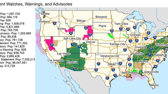
Active watches, warnings and advisories as of Tuesday morning, Aug. 31, 2021.
(NOAA/NWS)
NOAA's Weather Prediction Center is forecasting an additional 1 to 3 inches of rain for the western Florida Panhandle, eastern and northern Alabama and North Georgia through Wednesday morning.
Farther north in the Middle Tennessee Valley, Ohio Valley, central and southern Appalachians and mid-Atlantic region, 3 to 6 inches of rain is predicted to fall through Thursday morning, with isolated higher amounts possible.
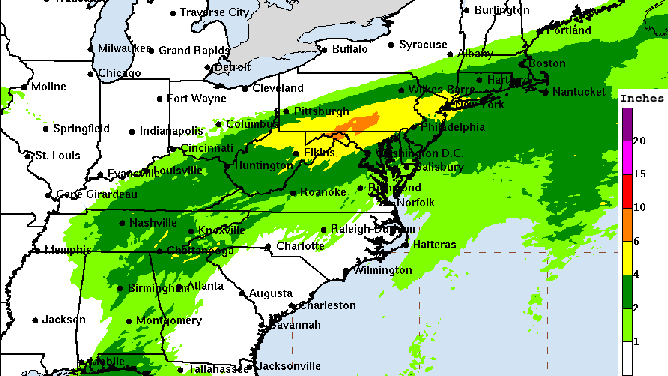
Forecast rainfall from Ida through Friday morning.
(NOAA/NWS/WPC)
In southern New England, 2 to 4 inches of rain is expected to fall Wednesday into Thursday, with isolated higher amounts possible there as well.
2 DEAD AS CARS PLUNGE FROM MISSISSIPPI HIGHWAY WASHED OUT FROM HURRICANE IDA RAINS
The WPC has highlighted portions of the Tennessee and Ohio valleys for a moderate risk (level 2 out of 4) of flash flooding on Tuesday. Areas from the central Appalachians into the mid-Atlantic and southern New England are highlighted for a moderate flash-flood risk on Wednesday.
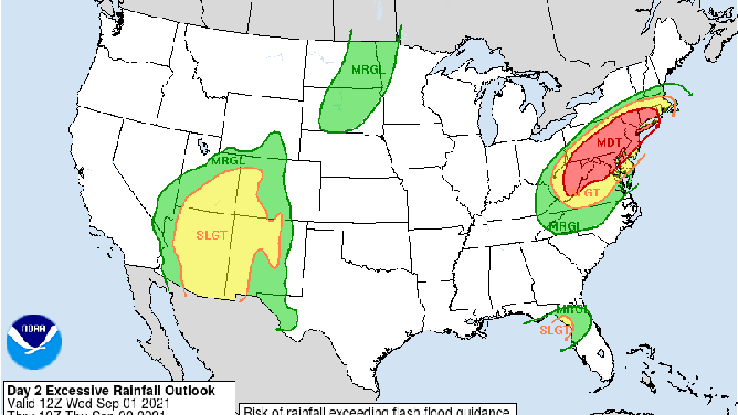
Excessive rainfall outlook for Wednesday, Sept. 1, 2021.
(NOAA/WPC)
"Considerable flash flooding is possible from the Middle Tennessee Valley, Ohio Valley, central and southern Appalachians into the mid-Atlantic and southern New England, with additional widespread moderate and isolated major river flooding impacts forecast from northern West Virginia and western Maryland into southern Pennsylvania and New Jersey," the WPC said in its 10 a.m. Central time advisory for Tropical Depression Ida.
Widespread minor to isolated major river flooding is also ongoing or forecast to occur from the lower Mississippi Valley into far western Alabama. Rivers across this region will remain elevated into next week, according to the WPC.
In addition to the dangerous flooding threat, there's also a risk for a couple of tornadoes across eastern Alabama, western Georgia and the Florida Panhandle through Tuesday evening. On Wednesday, a few tornadoes are possible in portions of the mid-Atlantic states as Ida moves northeastward.