Storm brings icy mix of freezing rain, snow to New England
A glaze of ice across parts of New England Friday could cause slick roads and downed power lines, with a bout of freezing rain even possible around Boston later Friday evening.

Ice and snow will create dangerous travel conditions in parts of New England
Ice and snow will create dangerous travel conditions Friday across parts of New England. Up to 0.25" of ice is possible which will lead not only to slick road conditions, but a few power outages and tree damage as well.
A mix of snow, sleet and freezing rain is heading through New England to end the workweek, threatening to make driving difficult.
THE HIDDEN DANGERS OF ICE STORMS. HERE'S WHAT YOU NEED TO KNOW
Freezing rain falls across upstate New York during morning commute
The icy mix moved in before sunrise just in time for the Friday morning commute across portions of upstate New York.
Massena, New York, near the Canadian border, observed one-third inch of ice accretion early Friday morning, while light freezing rain amounts were reported around Buffalo, Rochester and Oswego.
Freezing rain and snow was just moving into northeastern New York and Vermont by late morning, eventually heading east into Maine and Massachusetts later in the day. Boston may even see some freezing rain later in the day, leading to icy conditions for the evening commute.
SNOW, SLEET, FREEZING RAIN AND HAIL: WHAT'S THE DIFFERENCE?
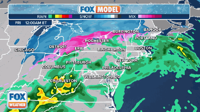
The FOX Forecast Center is tracking a dangerous mix of heavy snow, sleet and freezing rain heading through the Great Lakes and aiming for New England to end the workweek.
(FOX Weather)
How much ice will coat the region?
Generally, up to a quarter-inch of ice could accrete on roadways, which is more than enough to make driving difficult. Overpasses and bridges freeze first, so road conditions could change rapidly.
Ice accretion can weigh down power lines and tree branches, taking some of them down and potentially leading to scattered power outages, though outages were minimal as of late Friday morning.
HOW MUCH ICE IS NEEDED TO KNOCK OUT POWER, DAMAGE TREES?
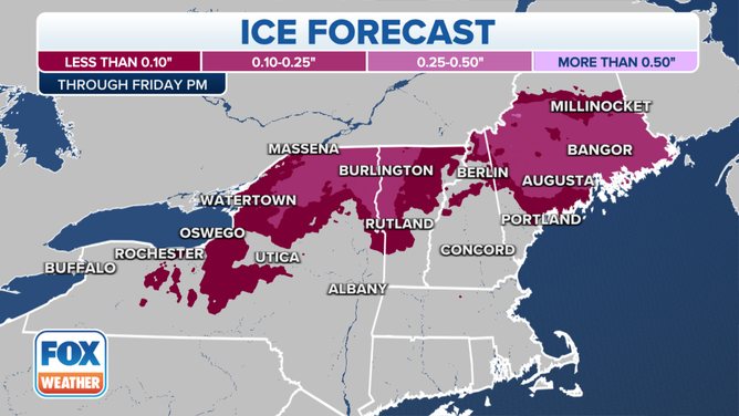
(FOX Weather)
Ice changes to snow later Friday
Much of the region will also get a light accumulation of snow on top of the ice as colder air moves in later in the day. The highest snow totals will be in northern Maine, where Houlton can expect 5 to 8 inches of snow while Caribou is in for up to a foot of snow.
The system will move out Friday night into Saturday morning.
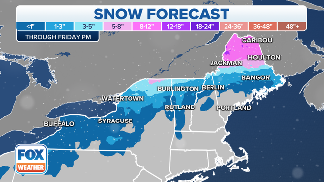
Northern Maine will need to have the plows ready.
(FOX Weather)