Bryan Norcross: Hurricane season might start up again in the Caribbean
If a threat develops, it would most likely be to the northern Caribbean islands. The timing would be toward the end of next week if a system gets organized.

FOX Weather is your Hurricane HQ, streaming free 24/7.
(FOX Weather)
Updated at 8:30 a.m. EST Friday
A large, weak area of low pressure is straddling Central America, causing disturbed weather over the Pacific and the extreme southern Caribbean waters on both sides of Panama. This feature, called the Central American Gyre, is common late in the hurricane season. Sometimes, a disturbance can consolidate from the Caribbean part of the system and develop into a tropical depression or tropical storm.
The consensus of the long-range computer forecasts is that a broad disturbance will try to organize over the next week in the extreme southern Caribbean Sea. The National Hurricane Center is giving that a slight chance of happening.
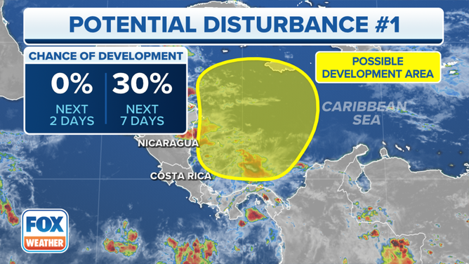
The outlook for a potential disturbance in the southwestern Caribbean Sea.
(FOX Weather)
There is little consensus on what happens if and when it develops. An upper-level disturbance – a dip in the jet stream – is forecast to move across the Gulf of Mexico about midweek next week. This system might or might not scoop up the Caribbean disturbance and pull it north.
If a threat develops, it would most likely be to the northern Caribbean islands. The timing would be toward the end of next week if a system gets organized. Plan to stay informed next week in Puerto Rico and the surrounding islands.
Cold fronts and the jet stream are doing a good job keeping tropical systems away from the continental U.S. and surrounding areas.