Hurricane Larry to bring life-threatening rip currents to East Coast; Invest 91L to enhance Southeast rainfall
Be sure to follow the orders of lifeguards if you have beach plans along the East Coast
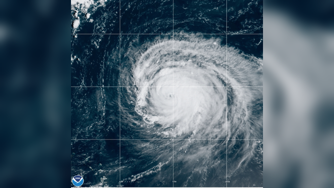
GOES-East GeoColor satellite imagery captured Category 3 Hurricane Larry over the open Atlantic Ocean Tuesday morning, Sept. 7, 2021.
(NOAA/NESDIS/STAR)
Hurricane Larry will remain hundreds of miles off the East Coast of the United States, but it's still expected to produce life-threatening surf and rip currents along much of the coastline in the week ahead.
As of 11 a.m. Eastern time Tuesday, Larry was centered more than 700 miles southeast of Bermuda as a Category 3 hurricane on the Saffir-Simpson Hurricane Wind Scale. An Air Force Reserve Hurricane Hunter aircraft was investigating the storm Tuesday morning.
OVER THE ATLANTIC - View within the eye of Hurricane #Larry from @NOAA WP-3D Orion #NOAA43 Miss Piggy during the September 6, 2021 mission. Credit: Cmdr. Didier, NOAA Corps.
— NOAA Aircraft Operations Center (@NOAA_HurrHunter) September 7, 2021
Follow @NHC_Atlantic for forecasts and advisories on this storm.#FlyNOAA #aviation #science pic.twitter.com/VKdK1F3RdE
Larry was moving northwestward at about 10 mph, and this general motion is expected to continue through Wednesday. According to the National Hurricane Center, a turn toward the north-northwest and north, along with an increase in forward speed, is predicted on Thursday.
Gradual weakening is predicted during the next several days. However, this path will take Larry just east of Bermuda on Thursday as a Category 2 hurricane.
HOW ARE HURRICANES RATED? THE SAFFIR-SIMPSON HURRICANE WIND SCALE EXPLAINED
The Bermuda Weather Service has issued a Tropical Storm Watch for the archipelago. This means tropical-storm-force winds (39-plus mph) are possible on Bermuda within 48 hours.
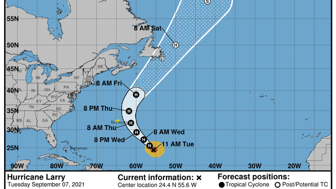
The forecast cone for Hurricane Larry issued by the National Hurricane Center at 11 a.m. Eastern time Tuesday.
(NOAA/NHC)
Even though Larry will remain far away from the U.S., life-threatening surf and rip currents are expected to reach the East Coast by midweek.
"Significant swells should reach the East Coast of the United States and Atlantic Canada by midweek and continue affecting these shores through the end of the week," the NHC said. "These swells are likely to cause life-threatening surf and rip current conditions."
Many beaches along the coast have a moderate risk of rip currents on Tuesday and a high risk on Wednesday.
As of Monday, 76 people in the U.S. had lost their lives to rip currents and high surf in 2021, according to NOAA.
Don't become a statistic. Be sure to follow the orders of lifeguards if you have beach plans this week.
Invest 91L in the Gulf of Mexico to enhance rainfall in southeastern U.S.
While Larry is the only active storm in the Atlantic, the NHC is also monitoring a tropical disturbance that's producing disorganized showers and thunderstorms over the south-central Gulf of Mexico.
This disturbance has been dubbed Invest 91L, which is simply a naming convention used by the NHC to identify areas it is investigating for possible development into a tropical depression or tropical storm within the next five days.
The system is expected to move slowly northeastward over the central and northeastern Gulf of Mexico during the next couple of days.
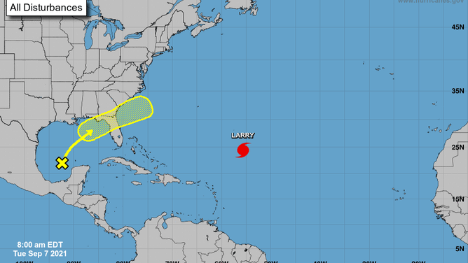
Invest 91L is denoted by the yellow "X," and its potential area of development in the next five days is highlighted in yellow.
(NOAA/NHC)
Upper-level winds are currently unfavorable for development, but they are forecast to become marginally conducive for some limited development as the disturbance approaches the northern Gulf Coast on Wednesday and Wednesday night, the NHC said.
Invest 91L is then expected to cross the Southeast, and some tropical or subtropical development is possible after it emerges over the southwestern Atlantic Ocean late this week.
Regardless of development, this system will enhance rainfall in portions of the Southeast. Areas of heavy rain could trigger localized flash flooding through the end of the week, especially from southern Alabama into North Florida and South Georgia.