Ida triggers Hurricane Warnings for Gulf Coast ahead of Category 4 landfall in Louisiana Sunday
Ida made its first landfall on Cuba's Isle of Youth Friday afternoon
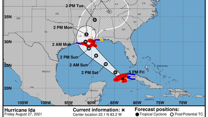
The forecast cone for Hurricane Ida issued by the National Hurricane Center on Friday at 5 p.m. Eastern time.
(NOAA/NHC)
Hurricane Ida is forecast to rapidly intensify over the Gulf of Mexico, becoming a Category 4 "major" hurricane before it makes landfall along the Louisiana coastline Sunday.
The National Hurricane Center's advisory issued Friday at 5 p.m. Eastern time predicts Ida will reach Category 3 intensity – a major hurricane – by Saturday afternoon, eventually reaching Category 4 intensity and packing winds of 140 mph by Sunday afternoon. It's expected to approach the coast of Louisiana Sunday afternoon or evening.
Ida is likely to undergo "rapid intensification" as it moves over the extremely warm waters of the Gulf of Mexico. That means its maximum sustained winds will increase by at least 35 mph in a 24-hour period.
The Friday afternoon forecast issued by the NHC predicts Ida's winds will increase from 80 mph to 120 mph between Friday at 5 p.m. Eastern and Saturday at 2 p.m. Eastern. That's an increase of 40 mph in less than 24 hours, so the storm would officially undergo rapid intensification if this forecast turns out to be correct.
WHAT DOES IT MEAN WHEN A HURRICANE UNDERGOES ‘RAPID INTENSIFICATION’?
Watches and warnings as of Friday afternoon
- A Hurricane Warning is in effect from Intracoastal City, Louisiana, eastward to the mouth of the Pearl River, including the New Orleans metro area, Lake Pontchartrain and Lake Maurepas. A Hurricane Warning is also in effect for the Cuban provinces of Pinar del Rio and Artemisa, as well as the Isle of Youth.
- A Hurricane Watch is in effect from Cameron, Louisiana, to west of Intracoastal City, Louisiana, as well as from the mouth of the Pearl River to the Mississippi/Alabama border.
- A Storm Surge Warning is in effect from east of Rockefeller Wildlife Refuge, Louisiana, to the Mississippi/Alabama border, including Vermilion Bay, Lake Borgne, Lake Pontchartrain and Lake Maurepas.
- A Storm Surge Watch is in effect from Sabine Pass to Rockefeller Wildlife Refuge, Louisiana, including Mobile Bay.
- A Tropical Storm Warning is in effect from Cameron, Louisiana, to west of Intracoastal City, Louisiana, as well as from the mouth of the Pearl River to the Mississippi/Alabama border. A Tropical Storm Warning is also in effect for the Cuban provinces of Matanzas, Mayabeque and Havana.
- A Tropical Storm Watch is in effect from the Mississippi/Alabama border eastward to the Alabama/Florida border.
Ida's status as of Friday afternoon
Hurricane Ida has maximum sustained winds of 80 mph. The storm is positioned northwest of Cuba's Isle of Youth, where it made its first landfall Friday afternoon. Ida is moving northwestward at 15 mph.
The NHC said the center of Ida will pass over western Cuba through Friday evening, then move over the southeastern and central Gulf of Mexico Friday night and Saturday. Ida is forecast to make landfall along the northern Gulf Coast of the United States within the Hurricane Warning area on Sunday.
Steady to rapid strengthening is expected when Ida moves over the southeastern and central Gulf of Mexico this weekend, and Ida is likely to be an extremely dangerous major hurricane when it approaches the northern Gulf Coast on Sunday.
Hurricane-force winds (74-plus mph) extend outward up to 25 miles from Ida's center, while tropical-storm-force winds (39-plus mph) extend outward up to 90 miles from the center. On Friday afternoon, sustained winds of 38 mph and a gust to 55 mph were reported at Cayo Largo, Cuba, according to the NHC.
Storm surge
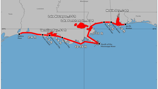
The peak storm surge predicted by the National Hurricane Center in its 5 p.m. Eastern time advisory on Friday.
(NOAA/NHC)
The NHC said a dangerous storm surge will raise water levels by as much as 4 to 6 feet above normal tide levels in areas of onshore winds along the immediate coast of the Isle of Youth and near and to the east of where the center crosses the coast of western Cuba. The surge will be accompanied by large and destructive waves as well.
The combination of a dangerous storm surge and the tide will cause normally dry areas near the coast to be flooded by rising waters moving inland from the shoreline. The water could reach the following heights above ground somewhere in the indicated areas if the peak storm surge occurs at the time of high tide:
- Morgan City, Louisiana, to the mouth of the Mississippi River: 10 to 15 feet
- Mouth of the Mississippi River to Ocean Springs, Mississippi, including Lake Borgne: 7 to 11 feet
- Intracoastal City, Louisiana, to Morgan City, Louisiana, including Vermilion Bay: 6 to 9 feet
- Ocean Springs, Mississippi, to the Mississippi/Alabama border: 4 to 7 feet
- Lake Pontchartrain: 4 to 7 feet
- Lake Maurepas: 3 to 5 feet
- Pecan Island, Louisiana, to Intracoastal City, Louisiana: 3 to 5 feet
- Mississippi/Alabama border to the Alabama/Florida border, including Mobile Bay...2 to 4 feet
- Sabine Pass to Pecan Island, Louisiana: 2 to 4 feet
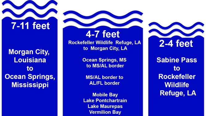
(Graphic: Infogram)
"Overtopping of local levees outside of the Hurricane and Storm Damage Risk Reduction System is possible where local inundation values may be higher than those shown above," the NHC said.
The deepest water will occur along the immediate coast near and to the east of the landfall location, where the surge will be accompanied by large and dangerous waves. Surge-related flooding depends on the relative timing of the surge and the tidal cycle, and it can vary greatly over short distances.
Wind
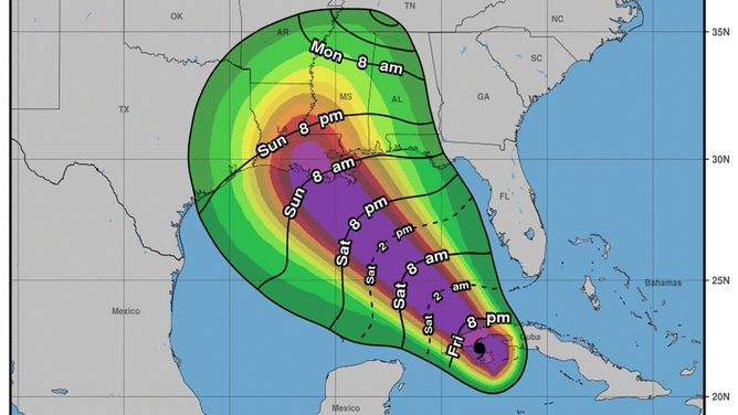
The most likely arrival time of tropical-storm-force winds (39-plus mph), according to the National Hurricane Center.
(NOAA/NHC)
Hurricane-force winds (74-plus mph) were occurring over Cuba's Isle of Youth and portions of western Cuba Friday afternoon and were expected to continue through Friday night.
Hurricane-force winds are expected in the Hurricane Warning area along the northern Gulf Coast beginning Sunday, with tropical-storm-force winds (39-plus mph) expected to begin by late Saturday night.
Rainfall
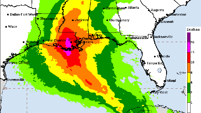
Rainfall forecast for Hurricane Ida.
(NOAA/NWS/WPC)
Hurricane Ida is expected to produce total rainfall accumulations of 6 to 10 inches, with maximum totals of 15 inches, across Jamaica.
Rainfall totals of 8 to 12 inches, with isolated maximum amounts of 20 inches, are expected across the Cayman Islands and western Cuba, including the Isle of Youth. These rainfall amounts may produce life-threatening flash floods and mudslides.
As Ida approaches the northern Gulf Coast Sunday afternoon, total rainfall accumulations of 8 to 16 inches, with isolated maximum amounts of 20 inches, are possible from southeastern Louisiana to coastal Mississippi and Alabama through Monday morning. This is expected to result in considerable flash, urban, small stream and river flooding, according to the NHC.
Ida is forecast to turn northeastward as it moves inland later Monday, with rainfall totals of 4 to 8 inches possible from southern and central Mississippi into the Tennessee Valley. This is also likely to result in flash, urban, small stream and river flooding.