New York Hurricane Evacuation Zones change for 1 million residents
The “Know Your Zone” campaign was launched by the New York City Emergency Management and is aimed at alerting people to the new zone changes
"Know Your Zone" is your destination for everything you need to know about hurricanes in New York City.
NEW YORK -- New York City is no stranger to tropical storms and hurricanes.
Superstorm Sandy in 2012 forced people to evacuate Long Island and coastal areas along the Northeast.
New York City Emergency Management Commissioner John Scrivani said he does not feel like people listened when they were ordered to evacuate.
"I think the problem was we had Hurricane Irene earlier in the year, and we evacuated, and the storm turned," he said. "So, I think of that, psychologically, people did not leave."
Scrivani said there were people who didn't leave that died, and he feels the bulk of the people who did leave knew that they were living along the waterfront.
HOW ARE HURRICANES RATED? THE SAFFIR-SIMPSON HURRICANE WIND SCALE EXPLAINED
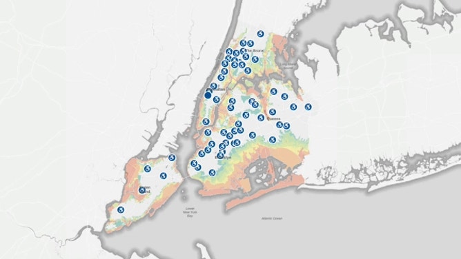
New York City emergency managers devise plans for moments like this as hurricanes barrel toward the East Coast. The plan includes hurricane evacuation zones with numerical designations of one through six.
"Zone 1 is basically along the shorelines of the city. Going inland, the zones increase by number," Scrivani said.
Now, they are rethinking the zones, meaning more people are at risk.
"The new (zones) added about 100,000 people total," Scrivani said. "There were about a million people that changed zones because of the redrawing of the lines and some zones increase. Some zones decreased with people."
How to find your hurricane evacuation zone
Knowing how you would evacuate in the event of a hurricane is an important part of preparing for that type of disaster.
The updates could be found on a map, but not all New Yorkers know about the changes. The "Know Your Zone" campaign, launched by New York City Emergency Management, is aimed at alerting people to the new zone changes.
"It's hard to know who's paying attention and who's actually going to take our word for what's happening," Scrivani said. "We hope and, you know, hope isn't really a plan. So, we really need to push our outreach effort."
The remapping of boundaries can be found online. Zones are labeled and color-coded on the interactive evacuation map. The updates are thanks to better, higher-resolution data. The hurricane evacuation zones were created based on the National Hurricane Slosh model.
HOW TO WATCH FOX WEATHER ON TV
Knowing your zone is only step one. City officials said you need to make an evacuation plan now and not wait.
"When the storm is coming, they should be prepared," Scrivani said. "We recommend that they try and have a plan to go to a friend's house or family's that live outside of the zones."
Emergency management works closely with the National Hurricane Center to find out which areas they think they'll be impacted.
"Then, it'll be a recommendation from the agency executives, like myself, to the mayor. The mayor ultimately makes a decision on who will evacuate," Scrivani said.
However, Scrivani said, the challenge is because some people have ridden out other storms or have watched areas get evacuated before a storm turns.
"So, they're very hesitant to leave sometimes. From my perspective … if we tell you to leave, there's a reason for that," he said.
CLICK HERE TO GET THE FOX WEATHER UPDATE PODCAST
But remember, things change fast. The average tropical storm speeds up the Northeast coast about 30 to 35 mph.
"We need to lean forward and not be afraid of, you know, possibly making a mistake on the too aggressive side. If you take less action, people could get hurt. If you take more action, people might be annoyed, and they might be upset that you made them leave their home, but they'll be safe," Scrivani said.
Just remember, it's good to be over-prepared than under-prepared.
Be sure to download the FOX Weather app to track any storms in your area and receive potentially life-saving weather alerts issued by the National Weather Service. The free FOX Weather livestream is also available 24/7 on the website and app and on your favorite streaming platform. The FOX Weather Update podcast also provides weather information for the entire country.