Hurricane Andrew timeline: On this day, August 25, 1992
The damage in Louisiana was dwarfed by the catastrophic impacts in Florida, but for people that lived through it, it was no less memorable.
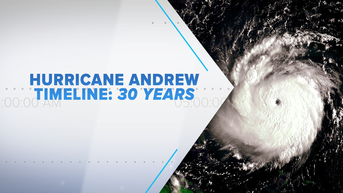
30 years later, Bryan Norcross re-lives Hurricane Andrew that devastated South Florida with a timeline detailing what happened.
(FOX Weather)
Just after 8:00 AM that Monday – August 24, 1992 – Hurricane Andrew crossed the southwest Florida coast south of Naples and headed into the Gulf of Mexico. The modern estimate is that the top winds had dropped to about 130 mph in the three-hour trip over the Everglades.
Andrew’s eye had become filled with clouds due to the circulation’s interaction with land. It was still very well organized, however, and the expectation was that the system would restrengthen over the Gulf.
By 2:00 PM, that was obviously happening as the eye started to clear out.
At 5:00 PM, the National Hurricane Center issued Hurricane Warnings for the Mississippi and southeastern Louisiana coasts, and a Hurricane Watch for the rest of the Louisiana coast west to Texas. NHC forecasters Max Mayfield and Lixion Avila were working in a severely wounded facility, but due to creative engineering and persistence, the alerts for the northern Gulf Coast went out.
Even with the mega hurricane bearing down on Greater Miami, we were worried about New Orleans. It seemed likely that the Andrew would turn into the northern Gulf, and indeed that was the forecast.
READ YESTERDAY'S POST FOR THE HURRICANE ANDREW TIMELINE: AUGUST 24, 1992
There is a storied history of big hurricanes hitting South Florida and later landing a hard hit on New Orleans. In 1947, the so-called Fort Lauderdale Hurricane hit the Florida coast as a Category 4 and then made landfall at the mouth of the Mississippi River in Louisiana two days later as a Category 2. It passed directly over New Orleans causing widespread flooding and damage.
In 1965, Category 3 Hurricane Betsy passed over the Upper Florida Keys, but was very damaging and disruptive in Miami. Two days later it tracked just west of New Orleans creating scenes evocative of the aftermath of Hurricane Katrina 40 years later. In fact, the flood-protection systems that failed in Katrina were (poorly) erected after the damage from Betsy.
That next morning, 30 years ago today – Tuesday, August 25, 1992 – the warnings we extended to Texas. At 10:00 AM Central Time they spanned all the way across Mississippi, Louisiana, and Texas east of Houston. The concern was that Andrew would slide along the coast affecting a large swath and increasing the uncertainty of where landfall would be.
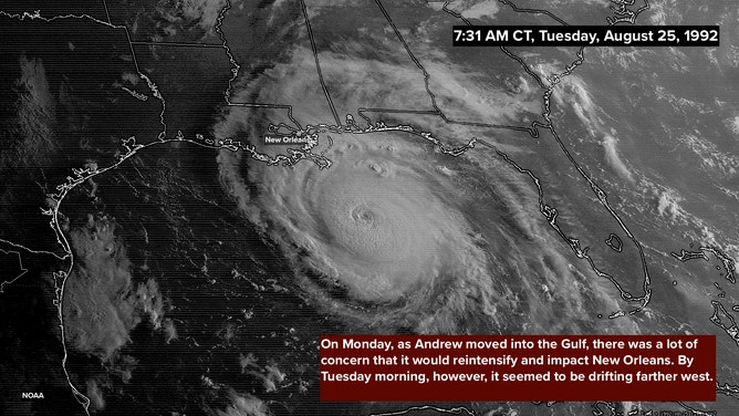
Satellite image on August 25, 1992 at 7:31 A.M. CDT showing Hurricane Andrew in the northern Gulf of Mexico.
(NOAA/NESDIS/NCEI)
Landfall was forecast the next morning, but it would be sooner or later depending on how far along the coastline Andrew tracked. Making it even more aggravating, the storm slowed down a bit, which added to the uncertainty.
Late that night, there were a couple of unanticipated changes. Andrew suddenly weakened over the shallow Gulf water along the Louisiana coast, and it turned north sooner than expected. Just offshore, the modern estimate is the top winds were 140 mph, but dropped to 115 mph in the two hours before landfall. It was still a powerful storm, but the feared Category 4 impact on Greater New Orleans had been avoided.
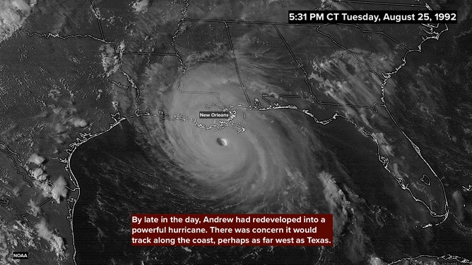
Satellite image on August 25, 1992 at 5:31 P.M. CDT showing Hurricane Andrew off the southeastern Louisiana coast.
(NOAA/NESDIS/NCEI)
Hurricane Andrew made landfall at about 3:00 AM Central Time, August 26, 1992, over the marshes just east of Cypremort Point along the central Louisiana coast. It swept north through Louisiana quickly weakening to a tropical storm. Two days later it died out over the mountains of eastern Tennessee.
Fortunately, it avoided the population centers in Louisiana, but still, losses in and around the state reached $2 billion. Flooding was extensive, and some 14 tornadoes were reported including a deadly twister that hit La Place, Louisiana, on the shore of Lake Pontchartrain.
The damage in Louisiana was dwarfed by the catastrophic impacts in Florida, but for people that lived through it, it was no less memorable.
Thirty years later we live with the lessons of Hurricane Andrew, and there were many. The most important one is, "The worst does happen." Nobody that went through it or has studied Andrew will ever say, "They always weaken or turn away." Because we know that’s true, except when it’s not.
Three decades ago, renowned hurricane specialist Bryan Norcross did a 23-hour marathon broadcast as Hurricane Andrew slammed into the Florida coast. His broadcast was the only one to stay on the air and many people’s only link to the outside world during the worst of the storm. He is credited with saving countless lives due to his life-saving advice. Now, 30 years later, Bryan will re-live the storm that devastated South Florida and look at the infrastructure changes that resulted. Watch The Wrath of Hurricane Andrew: Tragedy and Triumph on FOX Weather, premiering August 23rd and 24th at 10 P.M. EDT.
HOW TO WATCH FOX WEATHER ON TV
FOX Weather Hurricane Specialist Bryan Norcross has a podcast, Tracking the Tropics with Bryan Norcross, available now on FOX News Audio. You can get it on your device by clicking here.