Hurricane Andrew timeline: On this day, August 21, 1992
With only 60 mph winds that Friday afternoon, nowhere in my mind did I imagine Andrew’s assault on Dade County with winds of 165 mph and gusts to 200 mph or more. Looking back, it seems inconceivable that that Friday afternoon Hurricane Andrew was only 2 1/2 days from landfall.
30 years later, Bryan Norcross re-lives Hurricane Andrew that devastated South Florida with a timeline detailing what happened.
(FOX Weather)
Thirty years ago this afternoon – Friday, August 21, 1992 – Andrew was a tropical storm with winds now estimated at 60 mph. The system was obviously organizing, but the computer forecast models the National Hurricane Center most depended on showed the storm staying east of the Bahamas through the weekend and certainly not a threat to Greater Miami.
In those pre-internet days, we didn’t have access to the spaghetti models, such as they were, at the TV station. We relied on the non-public Technical Discussions the National Hurricane Center specialists wrote with each advisory to know what direction the various spaghetti plots indicated the storm might go. Other experimental computer models tried to predict how strong the storm would be, but we didn’t have much confidence in them at that time.
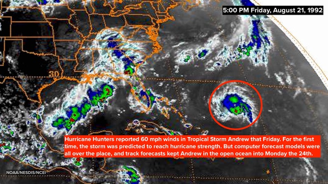
Satellite image on August 21, 1992 at 5:00 P.M. EDT showing an estimated 60-mph Tropical Storm Andrew.
(NOAA/NESDIS/NCEI)
The most important maps I received every day in the TV weather office were the printouts of a computer forecast model called the AVN – known as the Aviation. Today, the successor to that model is called the GFS for Global Forecast System. It’s the main weather forecast model run by the U.S. National Weather Service.
The maps that I was most interested in showed the general pattern of high- and low-pressure systems at the level in the atmosphere that determined which direction well-developed storms would be steered. The maps arrived in the weather office on an excruciatingly slow printer, and they arrive upside down. When time was of the essence, you had to wrench yourself around or stand on your head to see the details as the maps were coming in.
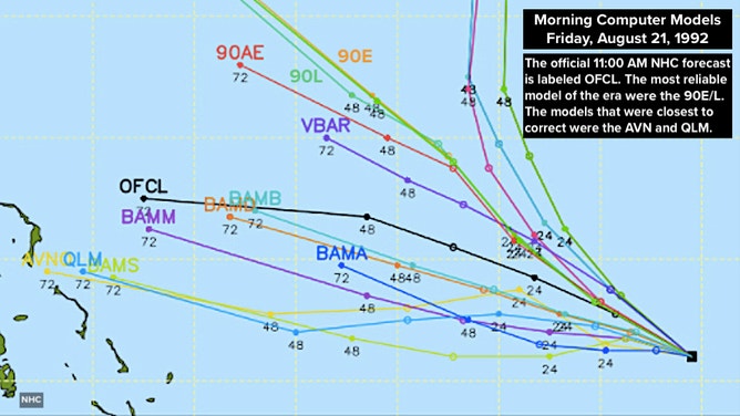
Computer forecast models from August 21, 1992 at 11:00 A.M. EDT showing the varying possibilities in the track of Andrew.
(NOAA/NHC)
READ YESTERDAY'S POST FOR THE HURRICANE ANDREW TIMELINE: AUGUST 20, 1992
That Friday, I especially wanted to see how the AVN was going to predict the high-pressure system off North Carolina would develop over the next three days. If the high strengthened, Andrew could not turn north. It would be blocked, and more likely be deflected toward Florida. In addition, a strengthening high likely meant the steering flow toward Florida would be stronger, meaning the storm might move more quickly toward the state. A faster approach speed would mean, obviously, that Andrew could arrive at the Florida coast sooner than we had been thinking.
When the Monday forecast map finally arrived about 3:30 PM, I strained to read the fuzzy print, which would tell me the projected strength of the potential blocking high. When the number finally came into view, my reaction was something like, "Holy crap!"
The high-pressure system was projected to be even stronger than I had imagined. An extra-strong high could do more than just block a northward turn, it could also push Andrew south. For the first time, there seemed to be a chance that South Florida could be threatened.
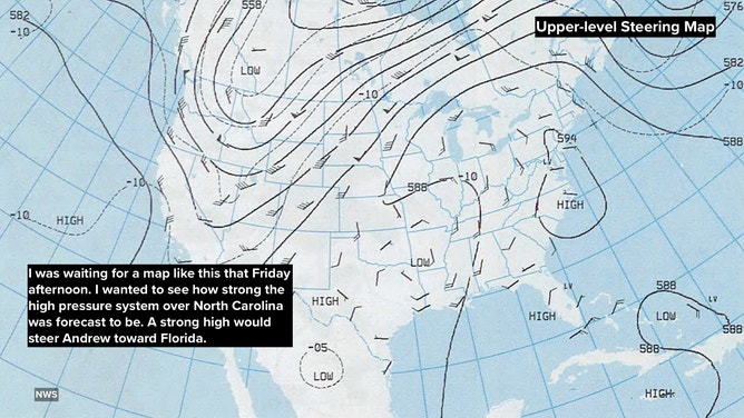
Upper-level steering weather map from August 21, 1992 showing the general pattern of high- and low-pressure systems at the level in the atmosphere
(NOAA)
In addition, there was a very practical matter in play. It was Friday. In 1992, most people didn’t have mobile phones, and many South Floridians would head out on their boat or down to the Keys to get away. The new school year would begin in just over a week, so people would want to soak in the end of summer. If Andrew made a turn toward Miami, it would be harder to inform people over the weekend.
I decided that we should discuss the possibility of a hurricane threat in detail on the news that Friday afternoon – not because I forecast Andrew to hit South Florida, but because I thought there was a risk it might. People needed to know there was a possibility they might have to jump into preparation mode if Andrew turned our way.
After the fact, I got credit for being the first one to forecast that Andrew was going to hit South Florida. But that wasn’t the case. National Hurricane Center forecaster Max Mayfield made note of the strong high-pressure system the AVN model was predicting in the non-public Technical Discussion at 5:00 PM that day. We were all looking at it. But I had the flexibility to talk about the risk of Andrew, in today’s language, staying on the left side of the cone.
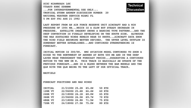
Technical Discussion from the National Hurricane Center at 5:00 P.M. EDT on August 21, 1992.
(NHC)
My decision to start the discussion of the possibility of a hurricane hit that Friday afternoon was based solely on communications concerns. I was worried that we couldn’t effectively get the word out over the weekend.
News Director Sharon Scott reconfigured the newscasts beginning at 5:00 PM. On the air, I discussed my concerns about the high-pressure system and Andrew, and we ran hurricane-preparedness videos that were produced for hurricane specials we had run earlier that year.
And thus began the extended TV coverage of the storm that changed everything. The unimaginable, Category 5 Hurricane Andrew.
At that point, I thought Andrew was more likely to hit somewhere north of Miami, though I wasn't ruling out anywhere as the impact point. But with only 60 mph winds that Friday afternoon, nowhere in my mind did I imagine Andrew’s assault on Dade County with winds of 165 mph and gusts to 200 mph or more.
Looking back, it seems inconceivable that that Friday afternoon Hurricane Andrew was only 2 1/2 days from landfall.
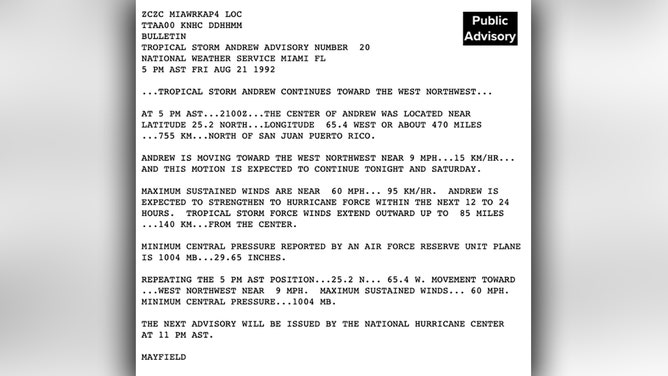
Public Advisory from the National Hurricane Center at 5:00 P.M. EDT on August 21, 1992.
(NHC)
Three decades ago, renowned hurricane specialist Bryan Norcross did a 23-hour marathon broadcast as Hurricane Andrew slammed into the Florida coast. His broadcast was the only one to stay on the air and many people’s only link to the outside world during the worst of the storm. He is credited with saving countless lives due to his life-saving advice. Now, 30 years later, Bryan will re-live the storm that devastated South Florida and look at the infrastructure changes that resulted. Watch The Wrath of Hurricane Andrew: Tragedy and Triumph on FOX Weather, premiering August 23rd and 24th at 10 P.M. EDT.
HOW TO WATCH FOX WEATHER ON TV
FOX Weather Hurricane Specialist Bryan Norcross has a podcast, Tracking the Tropics with Bryan Norcross, available now on FOX News Audio. You can get it on your device by clicking here.