First snow of season arrives in Northeast, including Boston and Washington, on Wednesday
The Interstate 95 corridor in New England from Boston to Providence, Rhode Island, is predicted to receive 1 to 2 inches of snow
First snow of season arrives in Northeast on Wednesday
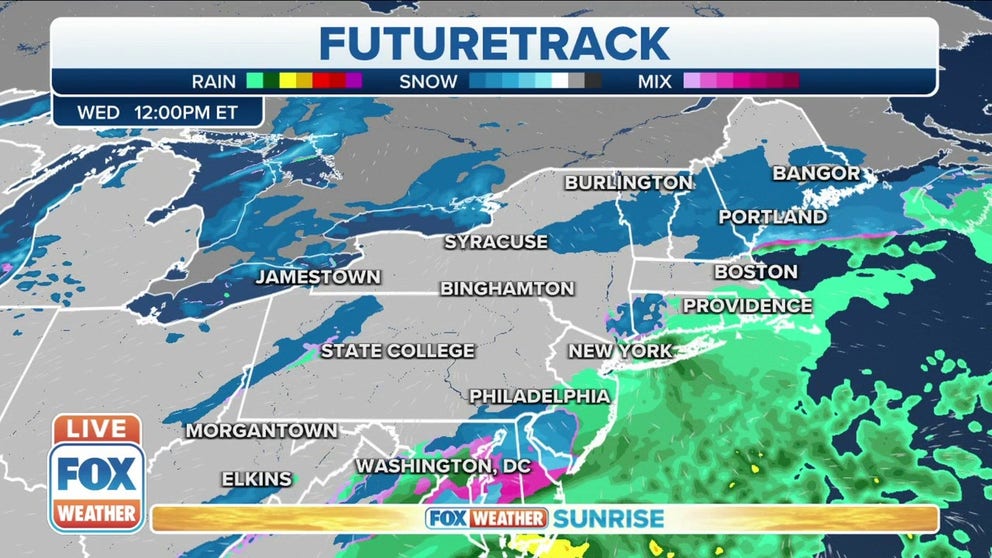
The first snow of the season is ahead for many in the Northeast, including Boston and Washington, as a new storm system moves up the East Coast on Wednesday.
The first snow of the season is arriving Wednesday for many in the Northeast, including Boston and Washington, as a new storm system moves up the East Coast.
While snowflakes might have already fallen from the sky in some areas, there has not yet been an official measurable snowfall (at least 0.1 inches) to whiten the ground in Boston, New York City, Philadelphia or Washington.
WHEN CAN YOU EXPECT THE FIRST SNOW OF THE SEASON?
The blue-shaded areas have already seen their first measurable snow (at least 0.1 inches) of the season.
(FOX Weather)
Boston has the best chance of accumulating snow on Wednesday among these major Northeast cities, but a few flakes are still possible in the D.C. area and perhaps New York and Philly.
An upper-level disturbance swinging out of the Ohio Valley is producing some light snow showers as it moves through the Northeast and northern mid-Atlantic region. Meanwhile, a developing coastal low near the North Carolina coast is moving up the Eastern Seaboard and will rapidly strengthen east of New England by Wednesday night.
However, these two features are not expected to combine and form a significant coastal storm, so any snow is likely to remain on the lighter side.
The Interstate 95 corridor in New England from Boston to Providence, Rhode Island, is predicted to receive 1 to 2 inches of snow from this system into Wednesday night.
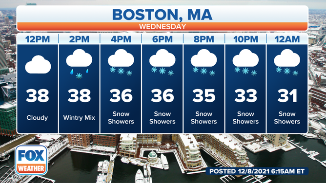
Hourly forecast for Boston on Wednesday, Dec. 8, 2021.
(FOX Weather)
Similar light snowfall amounts are expected into northern New England and back to the west over upstate New York.
WHICH IS THE SNOWIEST MONTH OF THE YEAR?
There's still a risk for some flurries or light snow farther south along Interstate 95 from the New York City tri-state area to the Philadelphia metro area and the nation's capital. Most places in this region will see no accumulation, though the Baltimore-to-Washington corridor has a slightly higher potential for at least a coating to half-inch of snow.
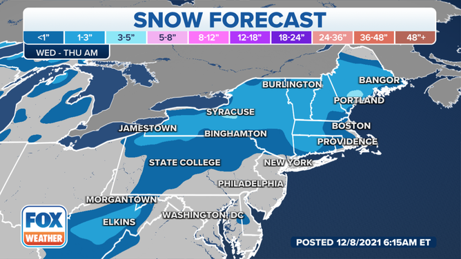
Snow forecast for Wednesday, Dec. 8, 2021.
(FOX Weather)